1990s Maps of Power County, Idaho
Explore 2 historic maps of Power County from the 1990s. These maps offer a rare glimpse into what life looked like during the 1990s — showing old roads, neighborhoods, homes, and landmarks that have changed or disappeared over time.
Whether you're researching your family's past, planning a metal detecting trip, or studying how Power County's landscape evolved across the 1990s, these high-resolution maps are a powerful tool for exploring the history of this region.
- Focus on a specific era: All maps on this page are from the 1990s, giving you a focused view of this time period.
- See what’s changed: Compare century-old streets, trails, and buildings to today's modern landscape using overlays and satellite layers.
- Research with precision: Use these maps for genealogy, historical research, land use analysis, or educational projects.
- View, download, or print: Maps are fully viewable online in high resolution, and can be downloaded or printed for your own records.
Start exploring Power County's history through authentic maps from the 1990s. This is your window into the past.
Power County, ID maps
(2)- 1993 Map of Oakley
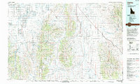 1993 Oakley1993 Print · USGSCassia County in the early nineties features a vast landscape of high-desert basins and granite formations. Genealogists and historians can trace the Hudspeth Cutoff, an Old Railroad Grade, and vanished towns like Churchill.
 - 1993 Map of Lake Walcott, 1994 Print
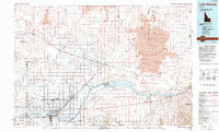 1993 Lake Walcott1994 Print · USGSMinidoka and Cassia counties come to life in the early nineties, showing a landscape shaped by the Snake River and extensive irrigation. Genealogists and local historians can trace family roots in Rupert, Burley, and smaller railroad stops like Kimama or Adelaide.
End of results
Showing maps 1-2 of 2
Top cities of Power County
Frequently asked questions
- What are the different types of historical maps available for Power County?
- What is the oldest map of Power County?
- Where can I purchase historical maps of Power County for my home or office?
- Where can I download high-res historical maps of Power County?
- Are there historical topographic maps available for Power County?
- Is there historical aerial imagery available for Power County?
- Where are historical maps of Power County sourced from?