Old Maps of Power County, Idaho for Genealogy
Trace your family roots with 253 historic maps of Power County. These high-res maps reveal old neighborhoods, homesites, landmarks, and streets — helping you uncover where your ancestors lived and how the area evolved over time.
- Explore historic neighborhoods: Identify where your relatives may have lived in the 1800s or 1900s.
- Compare maps over time: Trace the changes in streets, buildings, and landmarks for multi-generational research.
- Perfect for genealogy & ancestry research: Used by family historians and researchers to map out lineage and migration.
These maps are an incredible resource for exploring your personal connection to Power County's past.
Power County, ID maps
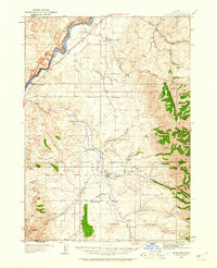
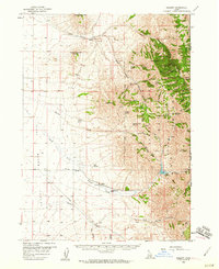
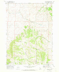
(253)- 1934 Map of American Falls, 1957 Print
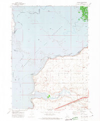
 1934 American Falls1957 Print · USGSThe Snake River region in the mid-1930s shows a landscape of massive water projects and ranching roots. Genealogists and historians can trace the Old Oregon Trail, locate remote rural schools like Mt Hope Sch, and see the early footprint of the American Falls Dam.
 - 1934 Map of Michaud, 1957 Print
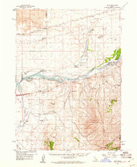
 1934 Michaud1957 Print · USGSThe Fort Hall Indian Reservation was undergoing significant changes in the 1930s as the American Falls Reservoir reshaped the valley. Genealogists and historians can trace the paths of the Oregon Trail, locate the Indian Cem, and find old rail stops at Schiller and Michaud.
 - 1934 Map of Rockland, 1960 Print
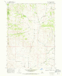
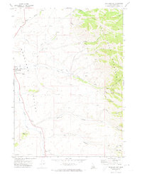
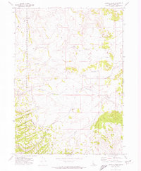
 1934 Rockland1960 Print · USGSPower County ranching and transit corridors are frozen in time during the mid-1930s, showing the early infrastructure of the Upper Snake River Valley. Researchers can trace the dual routes of the Oregon Trail and locate isolated schoolhouses like Garris Sch and Central Sch.2 unique versions available
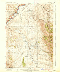
 - 1936 Map of American Falls
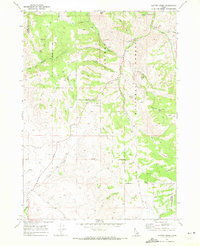
 1936 American Falls1936 Print · USGSPower and Bingham counties are captured in the mid-1930s, showing the early years of the massive reservoir on the Snake River. Genealogists and historians can trace family-named sites like Kerr Ranch and a network of schools including Williams Sch and Range Sch.
 - 1937 Map of Rockland
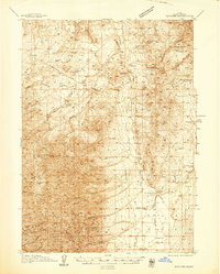
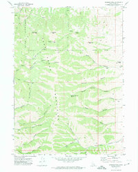
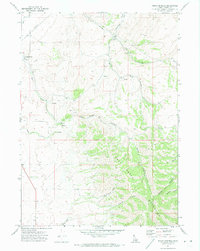
 1937 Rockland1937 Print · USGSRockland and the surrounding high-desert canyons are captured here in the mid-1930s as modern highways began to parallel historic western routes. Genealogists and historians can trace the Old Oregon Trail, locate the Cem at Rockland, and find rural schoolhouses like Cold Creek Sch and Garris Sch.2 unique versions available
 - 1937 Map of Pocatello
 1937 Pocatello1937 Print · USGSBannock County is captured in the late 1930s as a burgeoning rail and highway crossroads along the Portneuf River. Genealogists can locate family landmarks in old Alameda, trace the Fort Hall Mine, or find rural school sites like Blackrock Sch.3 unique versions available
 - 1937 Map of Michaud
 1937 Michaud1937 Print · USGSThe Fort Hall Indian Reservation and its mid-century transportation networks are documented here just as the aviation age was taking flight. Genealogists and historians can trace family-named sites and early infrastructure like the Indian School, Indian Cem, and the path of the Old Oregon Trail.
 - 1938 Map of Pauline
 1938 Pauline1938 Print · USGSBannock Valley in the late 1930s is a landscape of high-altitude ranching and early aviation landmarks. Genealogists and local historians can trace the foundations of Pauline and Arbon PO, or locate family sites like Rudeen Ranch and Armstrong Sch.
 - 1944 Map of Pocatello
 1944 Pocatello1944 Print · USGSBannock County and the Fort Hall Indian Reservation are captured here in the years leading up to the second World War. Researchers can trace the early streets of Pocatello and Alameda, or locate rural landmarks like the Portneuf Sch and the Fort Hall Mine.
 - 1944 Map of Arbon
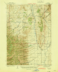 1944 Arbon1944 Print · USGSPower County ranching and early aviation mark this mid-century survey of the Idaho high country. Genealogists and historians can locate family holdings like Rudeen Ranch and Elkhead Ranch or trace the early community hubs of Arbon Sch and Pauline.2 unique versions available
 - 1954 Map of Pocatello, 1963 Print
 1954 Pocatello1963 Print · USGSSoutheast Idaho in the mid-1950s reveals a landscape shaped by massive water reclamation and mountain forests. Researchers can trace the development of the Fort Hall Indian Reservation or locate specific landmarks like the Arbon P O and Emerson School.4 unique versions available
 - 1955 Map of Idaho Falls, 1963 Print
 1955 Idaho Falls1963 Print · USGSThe Snake River Plain and its surrounding volcanic peaks are captured in the late fifties, showing the region's unique mix of nuclear research and high-desert ranching. Trace the industrial footprint of the National Reactor Testing Station or find old mining sites like Empire Mine.5 unique versions available
 - 1958 Map of Idaho Falls
 1958 Idaho Falls1958 Print · USGSEastern Idaho in the late fifties showcases the rapid expansion of agricultural and scientific outposts across its volcanic plains. Researchers can locate remote sites like Atomic City, mineral interests at White Knob Mine, and the cultural grounds of St Marys Mission.2 unique versions available
 - 1958 Map of Pocatello
 1958 Pocatello1958 Print · USGSSoutheastern Idaho in the late fifties was a landscape of expanding reservoirs and historic trails. Genealogists and historians can trace the Old Oregon Trail, locate the Bannock Creek Indian Day School, and study the many Union Pacific rail sidings.2 unique versions available
 - 1958 Map of Sublett, 1960 Print
 1958 Sublett1960 Print · USGSThe high country of Cassia County is captured here in the late fifties, showing the interplay between national forest lands and remote ranching. Researchers can locate named water sources like Moonshine Spring and trace the Van Camp Trail past Broken Circle Ranch.2 unique versions available
 - 1959 Map of Yale, 1961 Print
 1959 Yale1961 Print · USGSThe Snake River valley in the late fifties was a place of remote ranches and conservation efforts along the Minidoka National Wildlife Refuge. Researchers can locate legacy family holdings like Fenstermaker Ranch or trace the Union Pacific rail line through Wapi.2 unique versions available
 - 1968 Map of Dairy Creek, 1971 Print
 1968 Dairy Creek1971 Print · USGSOneida County's high country is captured here in the late sixties as a landscape of cattle-range canyons and mountain springs. Genealogists and historians can trace family-named landmarks like Harold Johns Canyon, the waters of Indian Mill Creek, and early routes like the Pack Trail.
 - 1968 Map of Clifton Creek, 1972 Print
 1968 Clifton Creek1972 Print · USGSPower and Bannock Counties in the late sixties remain a landscape of high-country trails and forest management. Researchers can trace the development of local recreation and transit at the Bannock Guard Station, Crystal, and the Bannock Highway.
 - 1968 Map of Bradley Mtn, 1973 Print
 1968 Bradley Mtn1973 Print · USGSPower and Bannock counties appear here in the late sixties as a high-altitude ranching and mining landscape. Researchers can trace the network of Jeep Trails connecting remote Mines, Eagle Pass, and numerous named water sources like Bull Spring.2 unique versions available
 - 1971 Map of Rockland East, 1973 Print
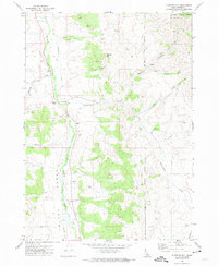
 1971 Rockland East1973 Print · USGSPower County, Idaho, in the early 1970s is documented here as a landscape of remote mountain canyons and high-valley ranching. Trace local genealogy and geography through landmarks like the Rockland settlement, the Cemetery, and the prominent Mollys Nipple peak.
 - 1971 Map of Bannock Peak, 1974 Print
 1971 Bannock Peak1974 Print · USGSThe Deep Creek Mountains are captured in the early seventies, showcasing the high-elevation terrain along the Fort Hall Indian Reservation Boundary. Researchers can trace old routes like the Sawmill Cr Trail or locate remote landmarks like Bannock Peak and White Quartz Mtn.
 - 1971 Map of Flatiron Hill, 1974 Print
 1971 Flatiron Hill1974 Print · USGSIn the early 1970s, this Power County landscape remained a rugged expanse of high-altitude ranching and forest lands. Genealogists and historians can trace the Fort Hall Indian Reservation Boundary and find local landmarks like Elkhead Ranch and the Cem.
 - 1971 Map of Schiller, 1974 Print
 1971 Schiller1974 Print · USGSPower County, Idaho, is captured here in the early 1970s as the regional economy revolved around the Snake River shoreline and the Michaud Flats. Genealogists and historians can trace the Union Pacific rail line, the rural settlement of Schiller, and the Indian Cem within the Fort Hall Indian Reservation.
 - 1971 Map of Sawmill Creek, 1974 Print
 1971 Sawmill Creek1974 Print · USGSPower County, Idaho, is shown in the early 1970s as a high-altitude landscape of springs and canyons along the reservation border. Trace historical paths like the Moonshine Trail and explore the geography of Sawmill Creek and Dry Canyon.
 - 1971 Map of Indian Springs, 1974 Print
 1971 Indian Springs1974 Print · USGSThe Deep Creek Mountains are captured here in the early 1970s, revealing a landscape of steep canyons and high-desert ranching. Researchers can trace land-use patterns at Garden Ranch, locate old Mines, and follow the path of Sunbeam Road.
Showing maps 1-25 of 253
Top cities of Power County
Frequently asked questions
- What are the different types of historical maps available for Power County?
- What is the oldest map of Power County?
- Where can I purchase historical maps of Power County for my home or office?
- Where can I download high-res historical maps of Power County?
- Are there historical topographic maps available for Power County?
- Is there historical aerial imagery available for Power County?
- Where are historical maps of Power County sourced from?