1960s Maps of Power County, Idaho
Explore 3 historic maps of Power County from the 1960s. These maps offer a rare glimpse into what life looked like during the 1960s — showing old roads, neighborhoods, homes, and landmarks that have changed or disappeared over time.
Whether you're researching your family's past, planning a metal detecting trip, or studying how Power County's landscape evolved across the 1960s, these high-resolution maps are a powerful tool for exploring the history of this region.
- Focus on a specific era: All maps on this page are from the 1960s, giving you a focused view of this time period.
- See what’s changed: Compare century-old streets, trails, and buildings to today's modern landscape using overlays and satellite layers.
- Research with precision: Use these maps for genealogy, historical research, land use analysis, or educational projects.
- View, download, or print: Maps are fully viewable online in high resolution, and can be downloaded or printed for your own records.
Start exploring Power County's history through authentic maps from the 1960s. This is your window into the past.
Power County, ID maps
(3)- 1968 Map of Dairy Creek, 1971 Print
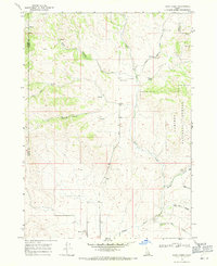 1968 Dairy Creek1971 Print · USGSOneida County's high country is captured here in the late sixties as a landscape of cattle-range canyons and mountain springs. Genealogists and historians can trace family-named landmarks like Harold Johns Canyon, the waters of Indian Mill Creek, and early routes like the Pack Trail.
 - 1968 Map of Clifton Creek, 1972 Print
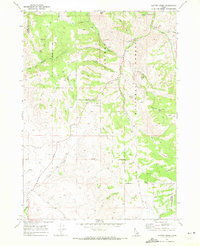 1968 Clifton Creek1972 Print · USGSPower and Bannock Counties in the late sixties remain a landscape of high-country trails and forest management. Researchers can trace the development of local recreation and transit at the Bannock Guard Station, Crystal, and the Bannock Highway.
 - 1968 Map of Bradley Mtn, 1973 Print
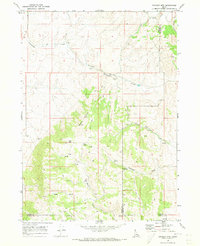 1968 Bradley Mtn1973 Print · USGSPower and Bannock counties appear here in the late sixties as a high-altitude ranching and mining landscape. Researchers can trace the network of Jeep Trails connecting remote Mines, Eagle Pass, and numerous named water sources like Bull Spring.2 unique versions available
End of results
Showing maps 1-3 of 3
Top cities of Power County
Frequently asked questions
- What are the different types of historical maps available for Power County?
- What is the oldest map of Power County?
- Where can I purchase historical maps of Power County for my home or office?
- Where can I download high-res historical maps of Power County?
- Are there historical topographic maps available for Power County?
- Is there historical aerial imagery available for Power County?
- Where are historical maps of Power County sourced from?