1990s Maps of Champaign County, Illinois
Explore 10 historic maps of Champaign County from the 1990s. These maps offer a rare glimpse into what life looked like during the 1990s — showing old roads, neighborhoods, homes, and landmarks that have changed or disappeared over time.
Whether you're researching your family's past, planning a metal detecting trip, or studying how Champaign County's landscape evolved across the 1990s, these high-resolution maps are a powerful tool for exploring the history of this region.
- Focus on a specific era: All maps on this page are from the 1990s, giving you a focused view of this time period.
- See what’s changed: Compare century-old streets, trails, and buildings to today's modern landscape using overlays and satellite layers.
- Research with precision: Use these maps for genealogy, historical research, land use analysis, or educational projects.
- View, download, or print: Maps are fully viewable online in high resolution, and can be downloaded or printed for your own records.
Start exploring Champaign County's history through authentic maps from the 1990s. This is your window into the past.
Champaign County, IL maps
(10)- 1990 Map of Peoria
 1990 Peoria1990 Print · USGSCentral Illinois at the start of the nineties reveals a landscape of industrial river towns and sprawling university campuses. Researchers can trace the legacy of major institutions like Chanute Air Force Base and the University of Illinois alongside regional landmarks such as Sand Ridge State Forest.
 - 1998 Map of Rising, 2001 Print
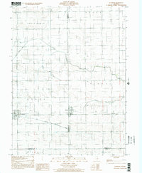
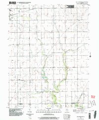
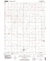
 1998 Rising2001 Print · USGSChampaign and the rural townships of Hensley and Condit are shown at the close of the twentieth century. Researchers can locate numerous historic family burial sites like Phillippe Cem and Bethlehem Cem along the Illinois Central Gulf railroad line.
 - 1998 Map of Urbana, 2001 Print
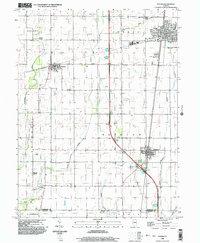
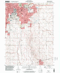 1998 Urbana2001 Print · USGSChampaign and Urbana are captured here in the late nineties, documenting the extensive footprint of the University of Illinois and its surrounding neighborhoods. Genealogists and historians can trace the paths of the Illinois Central Railroad and locate several outlying landmarks like Mt Hope Cemetery and the village of Philo.
 - 1998 Map of Bondville, 2001 Print
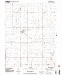
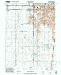 1998 Bondville2001 Print · USGSThe western suburbs of Champaign and the village of Bondville are captured in the late nineties as the urban fringe met the prairie. Trace the development of Willard Airport and find local landmarks like Prairieview Cem and Kenwood Sch.
 - 1998 Map of Allerton, 2002 Print
 1998 Allerton2002 Print · USGSEast-central Illinois farmlands near the turn of the millennium show a landscape shaped by the Little Vermilion River and the East Branch Embarras River. Genealogists can locate Lost Grove Cem and rural landmarks like Sch No 6 or the small settlement of Hastings.
 - 1998 Map of Thomasboro, 2002 Print
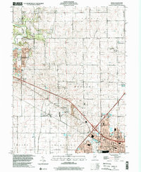
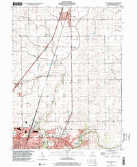 1998 Thomasboro2002 Print · USGSNorthern Champaign County at the close of the century shows a landscape defined by the Illinois Central Railroad and rising suburban density. Researchers can trace the roots of smaller communities like Leverett and Augerville or locate family plots in St Elizabeth Cem and Clements Cem.
 - 1998 Map of Villa Grove NW, 2003 Print
 1998 Villa Grove NW2003 Print · USGSChampaign County at the close of the twentieth century reveals a highly organized agricultural landscape shaped by the Embarras River. Researchers can trace local heritage through sites like Jessee Cem, St Mary Sch, and the Townhall in Crittenden.
 - 1998 Map of Ivesdale, 2003 Print
 1998 Ivesdale2003 Print · USGSIvesdale and the surrounding prairie townships appear in detail during the late nineties as the region's agricultural and drainage networks matured. Researchers can locate family burial sites at St Joseph Cem and Rice Cem or trace the early aviation footprint of the Kirwan Landing Strip.
 - 1998 Map of Tolono, 2003 Print
 1998 Tolono2003 Print · USGSChampaign County prairie life is centered on the railway and road corridors of the late twentieth century. Genealogists and local historians can trace family ties through several rural burial grounds, including Rock Cem, Sadorus Cem, and St Marys Cem.
 - 1998 Map of Longview, 2003 Print
 1998 Longview2003 Print · USGSThe rural borderlands of Champaign and Douglas counties are documented here in the late 1990s, showing a landscape defined by farming and small-town junctions. Local historians can trace family roots through sites like Lynn Grove Cemetery, Broadlands, and the Immaculate Conception Church.
End of results
Showing maps 1-10 of 10
Top cities of Champaign County
- Champaign historical maps
- Urbana historical maps
- Rantoul historical maps
- Mahomet historical maps
- Savoy historical maps
- Tolono historical maps
See more
Frequently asked questions
- What are the different types of historical maps available for Champaign County?
- What is the oldest map of Champaign County?
- Where can I purchase historical maps of Champaign County for my home or office?
- Where can I download high-res historical maps of Champaign County?
- Are there historical topographic maps available for Champaign County?
- Is there historical aerial imagery available for Champaign County?
- Where are historical maps of Champaign County sourced from?