1940s Maps of Madison County, Illinois
Explore 8 historic maps of Madison County from the 1940s. These maps offer a rare glimpse into what life looked like during the 1940s — showing old roads, neighborhoods, homes, and landmarks that have changed or disappeared over time.
Whether you're researching your family's past, planning a metal detecting trip, or studying how Madison County's landscape evolved across the 1940s, these high-resolution maps are a powerful tool for exploring the history of this region.
- Focus on a specific era: All maps on this page are from the 1940s, giving you a focused view of this time period.
- See what’s changed: Compare century-old streets, trails, and buildings to today's modern landscape using overlays and satellite layers.
- Research with precision: Use these maps for genealogy, historical research, land use analysis, or educational projects.
- View, download, or print: Maps are fully viewable online in high resolution, and can be downloaded or printed for your own records.
Start exploring Madison County's history through authentic maps from the 1940s. This is your window into the past.
Madison County, IL maps
(8)- 1940 Map of Granite City
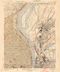 1940 Granite City1940 Print · USGSThe industrial heart of the bi-state region comes alive in this 1940s survey of the riverfront between Illinois and Missouri. Researchers can trace the massive rail yards and river docks supporting Granite City, alongside historic landmarks like Union Station, St Louis University, and the Bellefontaine Cemetery.4 unique versions available
 - 1944 Map of New Douglas
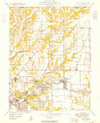
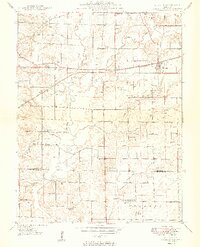
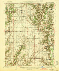 1944 New Douglas1944 Print · USGSMadison and Bond Counties are seen here during the mid-1930s, showing a well-established network of prairie farming communities and rail lines. Genealogists can locate dozens of named rural schools and cemeteries, from St Vincent Cem to the Hedgebound Sch and the village of Grantfork.2 unique versions available
 - 1948 Map of Quincy
 1948 Quincy1948 Print · USGSThe Mississippi and Illinois River valleys are captured at a post-war crossroads as rail and river travel met the expanding highway system. Genealogists can trace family settlements from Quincy to Hannibal and smaller towns like Vandalia and Jerseyville.2 unique versions available
 - 1948 Map of Alton, 1954 Print
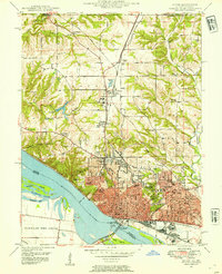 1948 Alton1954 Print · USGSAlton and the Mississippi River bluffs are captured here in the late Forties, showing a region defined by its heavy rail industry and prominent educational institutions. Genealogists and historians can locate Shurtleff College, the Confederate Cem, and the tracks of the Chicago and Alton railroad.
 - 1948 Map of Wood River, 1955 Print
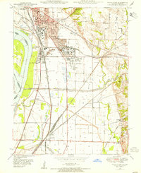 1948 Wood River1955 Print · USGSMadison County industrial hubs and river lowlands are captured here in the late 1940s as the regional energy sector expanded. Genealogists and historians can trace the foundations of Wood River refineries alongside local landmarks like St Paul Ch and the North Coal Mine.
 - 1949 Map of Saint Louis
 1949 Saint Louis1949 Print · USGSGreater St. Louis and its surrounding river valleys are captured here just after the war, showing the metropolitan core and the rural Ozark fringe. Researchers can trace the sprawling rail network of the Wabash RR or locate landmarks like Meramec Caverns Airport and Scott Air Force Base.2 unique versions available
 - 1949 Map of Bethalto
 1949 Bethalto1949 Print · USGSMadison County's post-war landscape comes alive in this late 1940s survey of the growing railroad and aviation corridor near the Mississippi. Genealogists and historians can trace the roots of local communities through landmarks like the Alton State Hospital, Ardent Mine, and rural schools like Sherfy Sch.
 - 1949 Map of St. Jacob
 1949 St. Jacob1949 Print · USGSMadison County's agricultural and rail corridor is meticulously detailed in the late 1940s, centered on the village of St Jacob. Researchers can trace dozens of family cemeteries and rural school sites like Gilead Sch, Terrapin Ridge, and the PENNSYLVANIA railroad line.2 unique versions available
End of results
Showing maps 1-8 of 8
Top cities of Madison County
- Granite City historical maps
- Edwardsville historical maps
- Alton historical maps
- Collinsville historical maps
- Godfrey historical maps
- Glen Carbon historical maps
See more
Frequently asked questions
- What are the different types of historical maps available for Madison County?
- What is the oldest map of Madison County?
- Where can I purchase historical maps of Madison County for my home or office?
- Where can I download high-res historical maps of Madison County?
- Are there historical topographic maps available for Madison County?
- Is there historical aerial imagery available for Madison County?
- Where are historical maps of Madison County sourced from?