1930s Maps of Madison County, Illinois
Explore 11 historic maps of Madison County from the 1930s. These maps offer a rare glimpse into what life looked like during the 1930s — showing old roads, neighborhoods, homes, and landmarks that have changed or disappeared over time.
Whether you're researching your family's past, planning a metal detecting trip, or studying how Madison County's landscape evolved across the 1930s, these high-resolution maps are a powerful tool for exploring the history of this region.
- Focus on a specific era: All maps on this page are from the 1930s, giving you a focused view of this time period.
- See what’s changed: Compare century-old streets, trails, and buildings to today's modern landscape using overlays and satellite layers.
- Research with precision: Use these maps for genealogy, historical research, land use analysis, or educational projects.
- View, download, or print: Maps are fully viewable online in high resolution, and can be downloaded or printed for your own records.
Start exploring Madison County's history through authentic maps from the 1930s. This is your window into the past.
Madison County, IL maps
(11)- 1930 Map of Jerseyville, 1965 Print
 1930 Jerseyville1965 Print · USGSJersey and Greene Counties are captured here between the world wars, showing a landscape defined by steam rail and one-room schoolhouses. Genealogists can trace the exact locations of Old Kane, the County Farm, and numerous local landmarks like St Marys Sch.2 unique versions available
 - 1932 Map of Edwardsville
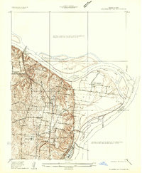
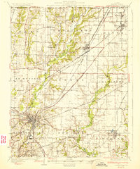 1932 Edwardsville1932 Print · USGSMadison County in the early thirties was a bustling intersection of coal mining and heavy rail. Genealogists can trace family names through dozens of rural schools and landmarks like the Klondike Mine, Sunset Hills Cem, and Le Claire.2 unique versions available
 - 1933 Map of Jerseyville
 1933 Jerseyville1933 Print · USGSJersey County is captured in the early thirties as a hub of rail activity and rural education. Genealogists can trace family roots through numerous local landmarks like Bethany Ch, Otterville, and the remote Shakerag Sch.2 unique versions available
 - 1933 Map of Granite City
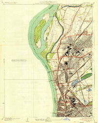
 1933 Granite City1933 Print · USGSThe riverfront and urban neighborhoods of St. Louis thrive during the early thirties as a hub of rail and river commerce. Genealogists and historians can trace family roots through numerous local parishes like St Joseph Ch and the vast Calvary Cemetery.2 unique versions available
 - 1933 Map of Saint Charles
 1933 Saint Charles1933 Print · USGSThe confluence of the Missouri and Mississippi rivers in the early thirties reveals a landscape of fertile river bottoms and emerging suburban rail towns. Genealogists and researchers can trace old school districts like Cul de Sac Sch and historic sites such as St Stanislaus Seminary.3 unique versions available
 - 1934 Map of Alton
 1934 Alton1934 Print · USGSThe confluence of the Mississippi and Missouri rivers in the early 1930s shows a dense industrial and rail corridor centered on Alton. Genealogists and researchers can trace dozens of rural schools and landmarks like Monticello Seminary, Mt Olive Church, and the City of St Louis Farms.2 unique versions available
 - 1935 Map of Granite City
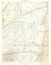
 1935 Granite City1935 Print · USGSThe industrial riverfront of Madison County thrives in the mid-1930s, showing a dense landscape of rail yards and expanding cities. Researchers can trace the complex trackage of the ILLINOIS TERMINAL RR and locate landmarks like the NATIONAL STOCK YARDS or Wilson Park.2 unique versions available
 - 1935 Map of Monks Mound
 1935 Monks Mound1935 Print · USGSThe American Bottoms near East St. Louis come alive in the mid-1930s, showing a unique landscape where ancient earthworks meet industrial rail expansion. Researchers can trace the layout of Cahokia Mounds State Park alongside defunct social landmarks like the Fairmont Jockey Club and Madison Kennel Club.3 unique versions available
 - 1935 Map of Columbia Bottom
 1935 Columbia Bottom1935 Print · USGSSt. Louis County and the river confluence are captured here in the mid-1930s, showing a landscape of municipal farms and rural school districts. Genealogists can trace local roots through landmarks like Ruegg PO, Larimore, and the Vossenkemper School.
 - 1937 Map of Collinsville
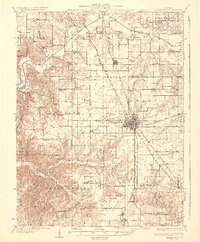
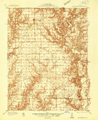
 1937 Collinsville1937 Print · USGSSouthwestern Illinois thrives in the mid-1930s as a hub of rail traffic and coal-country commerce. Genealogists and local historians can trace family locations near Chinatown, Donkville, and numerous country schools like Bethel Sch or Spring Valley Sch.2 unique versions available
 - 1937 Map of New Douglas
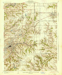
 1937 New Douglas1937 Print · USGSMadison and Bond counties are seen here in the late 1930s, showing a high density of rural schools and family cemeteries. Researchers can trace the grounds of Mt Calvary Sch, locate the St Vincent Cem, or follow the Shoal Creek bottomlands.2 unique versions available
End of results
Showing maps 1-11 of 11
Top cities of Madison County
- Granite City historical maps
- Edwardsville historical maps
- Alton historical maps
- Collinsville historical maps
- Godfrey historical maps
- Glen Carbon historical maps
See more
Frequently asked questions
- What are the different types of historical maps available for Madison County?
- What is the oldest map of Madison County?
- Where can I purchase historical maps of Madison County for my home or office?
- Where can I download high-res historical maps of Madison County?
- Are there historical topographic maps available for Madison County?
- Is there historical aerial imagery available for Madison County?
- Where are historical maps of Madison County sourced from?