Old Maps of Madison County, Illinois for Genealogy
Trace your family roots with 177 historic maps of Madison County. These high-res maps reveal old neighborhoods, homesites, landmarks, and streets — helping you uncover where your ancestors lived and how the area evolved over time.
- Explore historic neighborhoods: Identify where your relatives may have lived in the 1800s or 1900s.
- Compare maps over time: Trace the changes in streets, buildings, and landmarks for multi-generational research.
- Perfect for genealogy & ancestry research: Used by family historians and researchers to map out lineage and migration.
These maps are an incredible resource for exploring your personal connection to Madison County's past.
Madison County, IL maps
(177)- 1888 Map of St. Louis
 1888 St. Louis1888 Print · USGSThe Illinois bottomlands across from St. Louis come alive in the late nineteenth century as a massive railroad hub emerging from the river wetlands. Researchers can trace early rail junctions and settlements like French Village, the ancient Monks Mound, and the industrial waterfronts of Brooklyn and East St Louis.
 - 1906 Map of Breese, 1958 Print
 1906 Breese1958 Print · USGSThe Illinois prairie east of St. Louis is shown here at the turn of the century, when rail lines and rural school districts formed the backbone of local life. Genealogy researchers can locate dozens of country schools like Linden School and Ruth School near established towns like Breese and Germantown.
 - 1907 Map of Breese
 1907 Breese1907 Print · USGSClinton and St. Clair counties were a bustling network of rail-towns and rural school districts at the turn of the century. Researchers can trace ancestral property near dozens of family-named landmarks like Richter School, McKee School, or the small village of Damiansville.2 unique versions available
 - 1907 Map of Belleville
 1907 Belleville1907 Print · USGSSouthwestern Illinois is seen at a height of rail-driven expansion in the early twentieth century. Trace genealogy and land history in Belleville, O'Fallon, and Summerfield along the Vandalia System and other regional lines.3 unique versions available
 - 1925 Map of Brighton, 1958 Print
 1925 Brighton1958 Print · USGSSouthwestern Illinois was a bustling rail-and-farm corridor in the mid-1920s, characterized by numerous small settlements and village schoolhouses. Researchers can trace the vanished rural infrastructure of Medora, Piasa, and Woodburn, alongside over twenty named country schools like Brush College School.2 unique versions available
 - 1927 Map of Alton
 1927 Alton1927 Print · USGSThe industrial and riverfront corridor of the Mississippi and Missouri confluence is captured here during a period of heavy rail and ferry traffic. Researchers can trace historic family locations through dozens of rural landmarks like Monticello Seminary, Greenwood Cem, and the City of St Louis Farms.
 - 1927 Map of St. Charles, 1955 Print
 1927 St. Charles1955 Print · USGSThe Missouri and Mississippi rivers meet in this mid-century survey, showcasing a landscape of fertile bottomlands and early aviation hubs. Genealogists can trace family footprints through dozens of rural landmarks like St Stanislaus Seminary, Orchard Farm, and Cul de Sac Sch.2 unique versions available
 - 1927 Map of Edwardsville, 1957 Print
 1927 Edwardsville1957 Print · USGSMadison County at the end of the twenties shows a landscape defined by coal mining and a complex web of steam and electric rail. Genealogists and historians can trace family-named landmarks and rural hubs like the Klondike Mine, St Johns Ch, and dozens of country schools from Yorkville Sch to Sylvan Hill Sch.
 - 1928 Map of Brighton
 1928 Brighton1928 Print · USGSSouthwestern Illinois was a bustling network of rail-side towns and country school districts in the mid-1920s. Researchers can locate nearly thirty local schools including Brush College School and Washington School, or trace the tracks of the Chicago and Alton through Shipman and Brighton.2 unique versions available
 - 1930 Map of Jerseyville, 1965 Print
 1930 Jerseyville1965 Print · USGSJersey and Greene Counties are captured here between the world wars, showing a landscape defined by steam rail and one-room schoolhouses. Genealogists can trace the exact locations of Old Kane, the County Farm, and numerous local landmarks like St Marys Sch.2 unique versions available
 - 1932 Map of Edwardsville
 1932 Edwardsville1932 Print · USGSMadison County in the early thirties was a bustling intersection of coal mining and heavy rail. Genealogists can trace family names through dozens of rural schools and landmarks like the Klondike Mine, Sunset Hills Cem, and Le Claire.2 unique versions available
 - 1933 Map of Jerseyville
 1933 Jerseyville1933 Print · USGSJersey County is captured in the early thirties as a hub of rail activity and rural education. Genealogists can trace family roots through numerous local landmarks like Bethany Ch, Otterville, and the remote Shakerag Sch.2 unique versions available
 - 1933 Map of Granite City
 1933 Granite City1933 Print · USGSThe riverfront and urban neighborhoods of St. Louis thrive during the early thirties as a hub of rail and river commerce. Genealogists and historians can trace family roots through numerous local parishes like St Joseph Ch and the vast Calvary Cemetery.2 unique versions available
 - 1933 Map of Saint Charles
 1933 Saint Charles1933 Print · USGSThe confluence of the Missouri and Mississippi rivers in the early thirties reveals a landscape of fertile river bottoms and emerging suburban rail towns. Genealogists and researchers can trace old school districts like Cul de Sac Sch and historic sites such as St Stanislaus Seminary.3 unique versions available
 - 1934 Map of Alton
 1934 Alton1934 Print · USGSThe confluence of the Mississippi and Missouri rivers in the early 1930s shows a dense industrial and rail corridor centered on Alton. Genealogists and researchers can trace dozens of rural schools and landmarks like Monticello Seminary, Mt Olive Church, and the City of St Louis Farms.2 unique versions available
 - 1935 Map of Granite City
 1935 Granite City1935 Print · USGSThe industrial riverfront of Madison County thrives in the mid-1930s, showing a dense landscape of rail yards and expanding cities. Researchers can trace the complex trackage of the ILLINOIS TERMINAL RR and locate landmarks like the NATIONAL STOCK YARDS or Wilson Park.2 unique versions available
 - 1935 Map of Monks Mound
 1935 Monks Mound1935 Print · USGSThe American Bottoms near East St. Louis come alive in the mid-1930s, showing a unique landscape where ancient earthworks meet industrial rail expansion. Researchers can trace the layout of Cahokia Mounds State Park alongside defunct social landmarks like the Fairmont Jockey Club and Madison Kennel Club.3 unique versions available
 - 1935 Map of Columbia Bottom
 1935 Columbia Bottom1935 Print · USGSSt. Louis County and the river confluence are captured here in the mid-1930s, showing a landscape of municipal farms and rural school districts. Genealogists can trace local roots through landmarks like Ruegg PO, Larimore, and the Vossenkemper School.
 - 1937 Map of Collinsville
 1937 Collinsville1937 Print · USGSSouthwestern Illinois thrives in the mid-1930s as a hub of rail traffic and coal-country commerce. Genealogists and local historians can trace family locations near Chinatown, Donkville, and numerous country schools like Bethel Sch or Spring Valley Sch.2 unique versions available
 - 1937 Map of New Douglas
 1937 New Douglas1937 Print · USGSMadison and Bond counties are seen here in the late 1930s, showing a high density of rural schools and family cemeteries. Researchers can trace the grounds of Mt Calvary Sch, locate the St Vincent Cem, or follow the Shoal Creek bottomlands.2 unique versions available
 - 1940 Map of Granite City
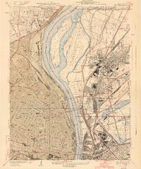 1940 Granite City1940 Print · USGSThe industrial heart of the bi-state region comes alive in this 1940s survey of the riverfront between Illinois and Missouri. Researchers can trace the massive rail yards and river docks supporting Granite City, alongside historic landmarks like Union Station, St Louis University, and the Bellefontaine Cemetery.4 unique versions available
 - 1944 Map of New Douglas
 1944 New Douglas1944 Print · USGSMadison and Bond Counties are seen here during the mid-1930s, showing a well-established network of prairie farming communities and rail lines. Genealogists can locate dozens of named rural schools and cemeteries, from St Vincent Cem to the Hedgebound Sch and the village of Grantfork.2 unique versions available
 - 1948 Map of Quincy
 1948 Quincy1948 Print · USGSThe Mississippi and Illinois River valleys are captured at a post-war crossroads as rail and river travel met the expanding highway system. Genealogists can trace family settlements from Quincy to Hannibal and smaller towns like Vandalia and Jerseyville.2 unique versions available
 - 1948 Map of Alton, 1954 Print
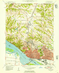 1948 Alton1954 Print · USGSAlton and the Mississippi River bluffs are captured here in the late Forties, showing a region defined by its heavy rail industry and prominent educational institutions. Genealogists and historians can locate Shurtleff College, the Confederate Cem, and the tracks of the Chicago and Alton railroad.
 - 1948 Map of Wood River, 1955 Print
 1948 Wood River1955 Print · USGSMadison County industrial hubs and river lowlands are captured here in the late 1940s as the regional energy sector expanded. Genealogists and historians can trace the foundations of Wood River refineries alongside local landmarks like St Paul Ch and the North Coal Mine.
Showing maps 1-25 of 177
Top cities of Madison County
- Granite City historical maps
- Edwardsville historical maps
- Alton historical maps
- Collinsville historical maps
- Godfrey historical maps
- Glen Carbon historical maps
See more
Frequently asked questions
- What are the different types of historical maps available for Madison County?
- What is the oldest map of Madison County?
- Where can I purchase historical maps of Madison County for my home or office?
- Where can I download high-res historical maps of Madison County?
- Are there historical topographic maps available for Madison County?
- Is there historical aerial imagery available for Madison County?
- Where are historical maps of Madison County sourced from?