1970s Maps of Madison County, Illinois
Explore 3 historic maps of Madison County from the 1970s. These maps offer a rare glimpse into what life looked like during the 1970s — showing old roads, neighborhoods, homes, and landmarks that have changed or disappeared over time.
Whether you're researching your family's past, planning a metal detecting trip, or studying how Madison County's landscape evolved across the 1970s, these high-resolution maps are a powerful tool for exploring the history of this region.
- Focus on a specific era: All maps on this page are from the 1970s, giving you a focused view of this time period.
- See what’s changed: Compare century-old streets, trails, and buildings to today's modern landscape using overlays and satellite layers.
- Research with precision: Use these maps for genealogy, historical research, land use analysis, or educational projects.
- View, download, or print: Maps are fully viewable online in high resolution, and can be downloaded or printed for your own records.
Start exploring Madison County's history through authentic maps from the 1970s. This is your window into the past.
Madison County, IL maps
(3)- 1974 Map of New Douglas, 1977 Print
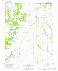 1974 New Douglas1977 Print · USGSThe rural borderlands of Madison and Macoupin counties are captured here in the mid-1970s as a vital crossroads for the Illinois rail industry. Genealogists and local historians can trace the foundations of Alhambra and Binney, or locate rural burial sites like St Ubaldus Cem and St Vincent Cem.
 - 1974 Map of Pocahontas, 1977 Print
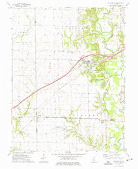 1974 Pocahontas1977 Print · USGSPocahontas and the border of Bond and Madison counties are shown in the mid-seventies just as the regional energy and rail landscape was shifting. Genealogists can locate family burial sites like Robison Cem and trace the early footprint of Pierron.
 - 1974 Map of Grant Ford, 1977 Print
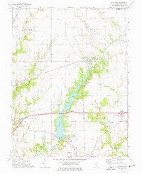 1974 Grant Ford1977 Print · USGSMadison County farmland and the waters of Highland Silver Lake define this mid-1970s survey of the Grantfork area. Local historians can trace family roots through several rural burial grounds like St Gertrudes Cem and Holtzgang Cem.
End of results
Showing maps 1-3 of 3
Top cities of Madison County
- Granite City historical maps
- Edwardsville historical maps
- Alton historical maps
- Collinsville historical maps
- Godfrey historical maps
- Glen Carbon historical maps
See more
Frequently asked questions
- What are the different types of historical maps available for Madison County?
- What is the oldest map of Madison County?
- Where can I purchase historical maps of Madison County for my home or office?
- Where can I download high-res historical maps of Madison County?
- Are there historical topographic maps available for Madison County?
- Is there historical aerial imagery available for Madison County?
- Where are historical maps of Madison County sourced from?