1990s Maps of Madison County, Illinois
Explore 15 historic maps of Madison County from the 1990s. These maps offer a rare glimpse into what life looked like during the 1990s — showing old roads, neighborhoods, homes, and landmarks that have changed or disappeared over time.
Whether you're researching your family's past, planning a metal detecting trip, or studying how Madison County's landscape evolved across the 1990s, these high-resolution maps are a powerful tool for exploring the history of this region.
- Focus on a specific era: All maps on this page are from the 1990s, giving you a focused view of this time period.
- See what’s changed: Compare century-old streets, trails, and buildings to today's modern landscape using overlays and satellite layers.
- Research with precision: Use these maps for genealogy, historical research, land use analysis, or educational projects.
- View, download, or print: Maps are fully viewable online in high resolution, and can be downloaded or printed for your own records.
Start exploring Madison County's history through authentic maps from the 1990s. This is your window into the past.
Madison County, IL maps
(15)- 1990 Map of Prairietown, 1991 Print
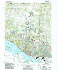
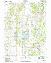 1990 Prairietown1991 Print · USGSMadison County's rural townships are captured here in the early nineties, showing a landscape of family farms and emerging lakeside residential life. Researchers can trace ancestral locations through several country churches and burial sites like St Johns Ch, Meyer Cem, and the Paddock Cem.
 - 1991 Map of St. Jacob
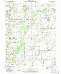 1991 St. Jacob1991 Print · USGSMadison County farmland near the turn of the 1990s was a patchwork of small family cemeteries and developing infrastructure. Genealogists can trace rural family roots at Gilead Cem and Wittman Cem, or locate the historic Old Railroad Grade near Triad High Sch.
 - 1991 Map of Collinsville
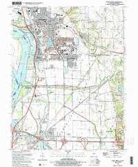
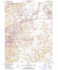 1991 Collinsville1991 Print · USGSThe Collinsville and Troy area comes alive in the early nineties as suburban neighborhoods began to weave through the older rural landscape. Researchers can trace family sites at St Pauls Cem or locate community landmarks like Maryville Sch and Troy Crossing.
 - 1991 Map of Marine
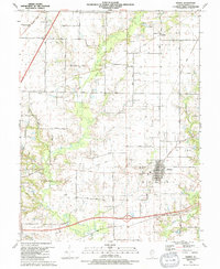 1991 Marine1991 Print · USGSMadison County in the early nineties reveals a quiet agricultural landscape transitioning between its pioneer roots and modern development. Genealogists and local historians can trace family locations through numerous sites like Marine Cem, Daugherty Cem, and the old Old Railroad Grade.
 - 1991 Map of Edwardsville
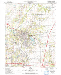 1991 Edwardsville1991 Print · USGSMadison County at the start of the nineties shows the growth of the EDWARDSVILLE and GLEN CARBON communities. Researchers can trace family sites and local landmarks from St Boniface Cem to the early campus layout of SOUTHERN ILLINOIS UNIVERSITY AT EDWARDSVILLE.
 - 1991 Map of Worden
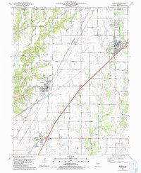 1991 Worden1991 Print · USGSMadison and Macoupin counties in the early nineties show a landscape shaped by coal mining and rural tradition. Genealogists can trace family names through numerous burial sites like Sandrach Cem and Spangle Cem or visit Miners Memorial Park.
 - 1991 Map of Elsah, 1995 Print
 1991 Elsah1995 Print · USGSThe Mississippi and Missouri rivers meet here in the early nineties, revealing a landscape of protective levees and riverfront villages. Genealogists can locate family names at St Francis Cem and Elsah Cem or trace the early river footprints of Portage Des Sioux and Machens.
 - 1993 Map of Bethalto, 1996 Print
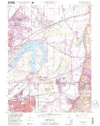
 1993 Bethalto1996 Print · USGSMadison County's residential and industrial growth is captured here in the 1990s as suburban expansion nears rural Macoupin County. Genealogists can trace family sites at Fosterburg Cem or locate the Alton Mental Health Ctr and St Louis Regional Airport.
 - 1993 Map of Granite City, 1996 Print
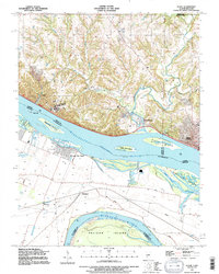
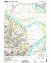
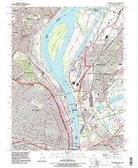 1993 Granite City1996 Print · USGSThe Mississippi riverfront near St. Louis and Granite City is shown here in the 1990s as a hub of industry and transit. Trace family plots in Calvary Cemetery or locate the Brooklyn (Lovejoy PO) post office and Mc Kinley Bridge.
 - 1994 Map of Alton
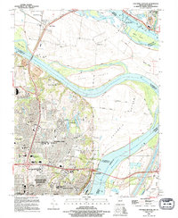
 1994 Alton1994 Print · USGSThe Mississippi riverfront near Alton and Godfrey comes into focus during the 1990s as a hub of commerce and education. Trace local history at the Confederate Cem, Ursuline Convent, or the Alton Lock and Dam No 26.
 - 1994 Map of Wood River, 1995 Print
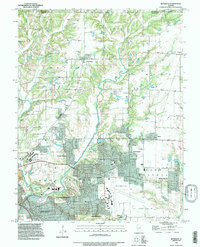
 1994 Wood River1995 Print · USGSThe industrial heart of Madison County and the lowlands of the Mississippi floodplain are detailed in this mid-nineties survey. Genealogists and local historians can trace family sites at Springley Cem, the grounds of Southern Illinois University, or the old rail stops at Poag.2 unique versions available
 - 1994 Map of Columbia Bottom, 1995 Print
 1994 Columbia Bottom1995 Print · USGSThe confluence of the great rivers north of St. Louis is shown in the mid-1990s, where suburban growth meets a complex network of levees and canals. Researchers can trace family history through sites like Villa Gesu Convent, Bailey Cem, and the old community at West Alton.
 - 1998 Map of Monks Mound, 1999 Print
 1998 Monks Mound1999 Print · USGSThe American Bottoms region near the Mississippi River was evolving quickly in the late twentieth century as urban industry met ancient landmarks. Genealogists and historians can trace the foundations of Fairmont City and Washington Park while locating Monks Mound and St Johns Cem.
 - 1998 Map of Columbia Bottom, 1999 Print
 1998 Columbia Bottom1999 Print · USGSThe confluence of the Missouri and Mississippi Rivers is captured here at the end of the century, showing a landscape of massive levees and growing suburban tracts. Researchers can trace the development of Bellefontaine Neighbors or locate community landmarks like Villa Gesu Convent and Fort Bellefontaine.
 - 1998 Map of Granite City, 1999 Print
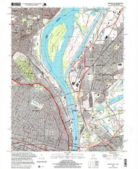 1998 Granite City1999 Print · USGSGreater St. Louis and the Illinois riverfront are captured here in the late 1990s as the region's industrial and river infrastructure remained in full force. Genealogists and historians can trace family plots in Calvary Cemetery or locate the historic Brooklyn (Lovejoy PO) and the Municipal Dock.
End of results
Showing maps 1-15 of 15
Top cities of Madison County
- Granite City historical maps
- Edwardsville historical maps
- Alton historical maps
- Collinsville historical maps
- Godfrey historical maps
- Glen Carbon historical maps
See more
Frequently asked questions
- What are the different types of historical maps available for Madison County?
- What is the oldest map of Madison County?
- Where can I purchase historical maps of Madison County for my home or office?
- Where can I download high-res historical maps of Madison County?
- Are there historical topographic maps available for Madison County?
- Is there historical aerial imagery available for Madison County?
- Where are historical maps of Madison County sourced from?