1930s Maps of Mason County, Illinois
Explore 5 historic maps of Mason County from the 1930s. These maps offer a rare glimpse into what life looked like during the 1930s — showing old roads, neighborhoods, homes, and landmarks that have changed or disappeared over time.
Whether you're researching your family's past, planning a metal detecting trip, or studying how Mason County's landscape evolved across the 1930s, these high-resolution maps are a powerful tool for exploring the history of this region.
- Focus on a specific era: All maps on this page are from the 1930s, giving you a focused view of this time period.
- See what’s changed: Compare century-old streets, trails, and buildings to today's modern landscape using overlays and satellite layers.
- Research with precision: Use these maps for genealogy, historical research, land use analysis, or educational projects.
- View, download, or print: Maps are fully viewable online in high resolution, and can be downloaded or printed for your own records.
Start exploring Mason County's history through authentic maps from the 1930s. This is your window into the past.
Mason County, IL maps
(5)- 1930 Map of Chandlerville
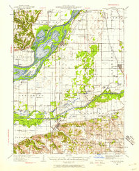 1930 Chandlerville1930 Print · USGSThe confluence of the Illinois and Sangamon rivers defines this Depression-era landscape of floodplains and island farms. Genealogists can trace family footprints across Grand Island or locate rural landmarks like Mt Olive Ch and the Chicago and Illinois Midland RR.2 unique versions available
 - 1932 Map of Chandlerville
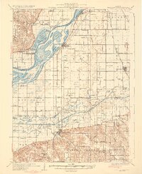 1932 Chandlerville1932 Print · USGSIn the 1930s, the Illinois River valley was a labyrinth of sloughs and landings centered around the Sangamon confluence. Genealogists can trace family roots through numerous rural schools like Blackjack Sch or explore old river sites like Snicarte and Matanzas Beach.2 unique versions available
 - 1932 Map of Manito
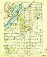 1932 Manito1932 Print · USGSThe Illinois River valley in the early 1930s showcases a landscape of intricate drainage ditches and river-bottom hunting clubs near Manito. Researchers can trace rural lineages through dozens of named sites like Eureka Sch, Ebenezer Ch, and Wessling Cem.3 unique versions available
 - 1933 Map of Petersburg, 1969 Print
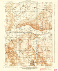
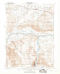 1933 Petersburg1969 Print · USGSThe Menard County landscape in the early thirties is a bustling network of prairie rail towns and riverside settlements. Genealogists and historians can trace family roots through numerous sites like Rose Hill Sch, Old Concord Cem, and the Indian Creek Mine.
 - 1938 Map of Petersburg
 1938 Petersburg1938 Print · USGSPetersburg and the Sangamon River valley are captured here in the late 1930s, showing a landscape defined by rail-stop hamlets and country schools. Researchers can trace family history through sites like Atterbury P O, the Verbrugge Mine, and Reavis Spring Sch.2 unique versions available
End of results
Showing maps 1-5 of 5
Top cities of Mason County
- Havana historical maps
- Mason City historical maps
- Manito historical maps
- Easton historical maps
- Kilbourne historical maps
- Bath historical maps
See more
Frequently asked questions
- What are the different types of historical maps available for Mason County?
- What is the oldest map of Mason County?
- Where can I purchase historical maps of Mason County for my home or office?
- Where can I download high-res historical maps of Mason County?
- Are there historical topographic maps available for Mason County?
- Is there historical aerial imagery available for Mason County?
- Where are historical maps of Mason County sourced from?