1970s Maps of Mason County, Illinois
Explore 7 historic maps of Mason County from the 1970s. These maps offer a rare glimpse into what life looked like during the 1970s — showing old roads, neighborhoods, homes, and landmarks that have changed or disappeared over time.
Whether you're researching your family's past, planning a metal detecting trip, or studying how Mason County's landscape evolved across the 1970s, these high-resolution maps are a powerful tool for exploring the history of this region.
- Focus on a specific era: All maps on this page are from the 1970s, giving you a focused view of this time period.
- See what’s changed: Compare century-old streets, trails, and buildings to today's modern landscape using overlays and satellite layers.
- Research with precision: Use these maps for genealogy, historical research, land use analysis, or educational projects.
- View, download, or print: Maps are fully viewable online in high resolution, and can be downloaded or printed for your own records.
Start exploring Mason County's history through authentic maps from the 1970s. This is your window into the past.
Mason County, IL maps
(7)- 1971 Map of Manito, 1973 Print
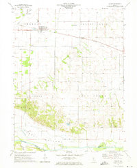
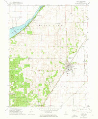 1971 Manito1973 Print · USGSIn the early seventies, the central Illinois prairie around Manito was a landscape of managed waterways and state timberlands. Trace family ties and local rail history through the Chicago and Illinois Midland tracks and sites like St Frederick Cem and Forest City.2 unique versions available
 - 1971 Map of Oakford, 1973 Print
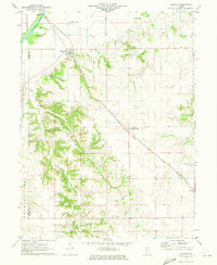 1971 Oakford1973 Print · USGSIn the early seventies, the Menard County countryside around Oakford remained a landscape of prairie rail lines and deeply etched creek hollows. Researchers can locate numerous family-named landmarks and burial sites like Watkins Cem, Bobtown, and the Atterberry rail station.
 - 1971 Map of South Pekin, 1973 Print
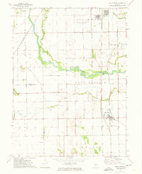 1971 South Pekin1973 Print · USGSCentral Illinois farming and rail life are preserved here in the early seventies, centered on the villages of South Pekin and Green Valley. Genealogists and historians can trace family roots at Old Sand Prairie Cem or locate old rural landmarks like Union Ch and The Mound.2 unique versions available
 - 1971 Map of Biggs, 1973 Print
 1971 Biggs1973 Print · USGSMason County at the start of the 1970s shows a landscape of river-fed bottomlands and rural rail stops. Genealogists can trace family landmarks like Baker Cem and New Lebanon Ch near the banks of Crane Creek.
 - 1971 Map of Easton, 1973 Print
 1971 Easton1973 Print · USGSThe village of Easton and the hamlet of Teheran anchor this Mason County landscape in the early seventies, dominated by the Illinois Central line. Researchers can trace rural cemetery sites like Leases Grove Cem and natural landmarks such as Revis Spring near the Sangamon River.
 - 1971 Map of Petersburg, 1973 Print
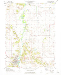 1971 Petersburg1973 Print · USGSMenard County in the early 1970s is defined by the winding Sangamon River and a dense network of early Illinois railroads. Family historians can trace numerous rural burial grounds like Rose Hill Cemetery and Baker Prairie Cem near the town of Petersburg.
 - 1975 Map of Chandlerville NW, 1976 Print
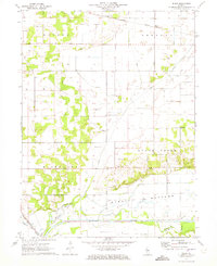
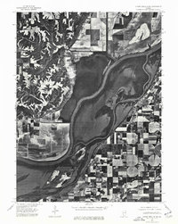 1975 Chandlerville NW1976 Print · USGSThe Illinois riverfront near Mason County comes to life in this mid-seventies aerial survey. Researchers can trace the layout of Bath and study the detailed agricultural patterns and backwaters surrounding the Illinois River.
End of results
Showing maps 1-7 of 7
Top cities of Mason County
- Havana historical maps
- Mason City historical maps
- Manito historical maps
- Easton historical maps
- Kilbourne historical maps
- Bath historical maps
See more
Frequently asked questions
- What are the different types of historical maps available for Mason County?
- What is the oldest map of Mason County?
- Where can I purchase historical maps of Mason County for my home or office?
- Where can I download high-res historical maps of Mason County?
- Are there historical topographic maps available for Mason County?
- Is there historical aerial imagery available for Mason County?
- Where are historical maps of Mason County sourced from?