Old Maps of Mason County, Illinois for Metal Detecting
Plan your next treasure hunt with 160 historic maps of Mason County. Find old homesites, ghost towns, trails, and gathering spots that may be lost to time — perfect for identifying promising metal detecting locations.
- Locate forgotten sites: Uncover places like long-lost settlements, abandoned rail lines, or gathering spots.
- Plan better hunts: Use map overlays combined with LiDAR or satellite views to narrow in on historically rich areas.
- Made for detectorists: Thousands of hobbyists use these maps to discover relics, coins, and hidden history.
Use these historic maps to boost your research and find new opportunities beneath the surface of Mason County.
Mason County, IL maps
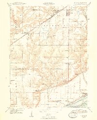
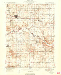
(160)- 1925 Map of Havana
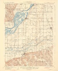
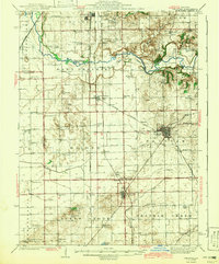
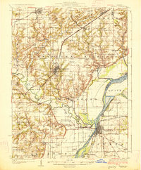 1925 Havana1925 Print · USGSThe Illinois River valley in the mid-1920s reveals a bustling corridor of coal mining and rail transport centered on Havana and Lewistown. Genealogists and historians can locate dozens of country schools and churches, such as Morning Star School and Mound Chapel.3 unique versions available
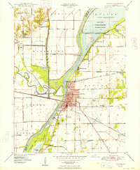
 - 1926 Map of Beardstown
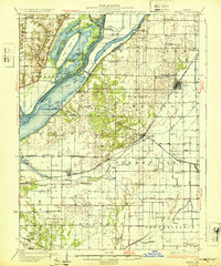
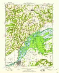
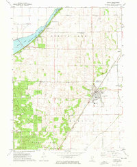
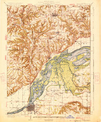 1926 Beardstown1926 Print · USGSThe Illinois River valley and its surrounding bluffs are shown in the mid-1920s, centered on the river hub of Beardstown. Genealogists can trace family ties to dozens of local landmarks, from Griggs Chapel and Mt Zion Church to rural schools like Good Hope School and Biren School.2 unique versions available
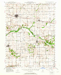
 - 1929 Map of Manito, 1972 Print
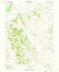
 1929 Manito1972 Print · USGSMason and Fulton counties in the late 1920s reveal a landscape of deep river bottoms and newly drained prairie. Researchers can trace family history through a dense network of country schools and churches like Coon Sch and Macedonia Ch, or locate the path of the Chicago and Illinois Midland railway.
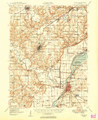
 - 1930 Map of Chandlerville
 1930 Chandlerville1930 Print · USGSThe confluence of the Illinois and Sangamon rivers defines this Depression-era landscape of floodplains and island farms. Genealogists can trace family footprints across Grand Island or locate rural landmarks like Mt Olive Ch and the Chicago and Illinois Midland RR.2 unique versions available
 - 1932 Map of Chandlerville
 1932 Chandlerville1932 Print · USGSIn the 1930s, the Illinois River valley was a labyrinth of sloughs and landings centered around the Sangamon confluence. Genealogists can trace family roots through numerous rural schools like Blackjack Sch or explore old river sites like Snicarte and Matanzas Beach.2 unique versions available
 - 1932 Map of Manito
 1932 Manito1932 Print · USGSThe Illinois River valley in the early 1930s showcases a landscape of intricate drainage ditches and river-bottom hunting clubs near Manito. Researchers can trace rural lineages through dozens of named sites like Eureka Sch, Ebenezer Ch, and Wessling Cem.3 unique versions available
 - 1933 Map of Petersburg, 1969 Print
 1933 Petersburg1969 Print · USGSThe Menard County landscape in the early thirties is a bustling network of prairie rail towns and riverside settlements. Genealogists and historians can trace family roots through numerous sites like Rose Hill Sch, Old Concord Cem, and the Indian Creek Mine.
 - 1938 Map of Petersburg
 1938 Petersburg1938 Print · USGSPetersburg and the Sangamon River valley are captured here in the late 1930s, showing a landscape defined by rail-stop hamlets and country schools. Researchers can trace family history through sites like Atterbury P O, the Verbrugge Mine, and Reavis Spring Sch.2 unique versions available
 - 1942 Map of Delavan
 1942 Delavan1942 Print · USGSTazewell County's fertile plains are captured in the early 1940s, showing a landscape defined by busy rail junctions and a dense grid of country schoolhouses. Researchers can trace family roots through landmarks like St Lukes Ch, South Pekin, and rural schools such as Oak Hill Sch.3 unique versions available
 - 1944 Map of Beardstown, 1959 Print
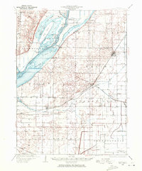
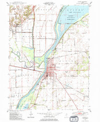
 1944 Beardstown1959 Print · USGSBeardstown and the Illinois River valley are shown here in the mid-forties, capturing a landscape of shifting river channels and rural school districts. Genealogists can trace family names through landmarks like Griggs Chapel, McClung School, and Sheldons Grove.2 unique versions available
 - 1947 Map of St. David, 1982 Print
 1947 St. David1982 Print · USGSFulton County industrial and river life are captured here in the late 1940s as large-scale extraction reshapes the prairie. Genealogists can trace family footprints at Salem Cem or locate vanished rural schools such as Elm Tree Sch and Maples Mill.
 - 1947 Map of Havana, 1984 Print
 1947 Havana1984 Print · USGSHavana and the Illinois River valley are captured here in the late 1940s, showing a landscape defined by rail transport and river management. Genealogists can trace family roots through numerous rural landmarks like Laurel Hill Cemetery, Waterford Union Ch, and the Morton School.
 - 1948 Map of St. David
 1948 St. David1948 Print · USGSCoal country meets the Illinois River valley in the late 1940s as strip mining reshapes the landscape near St. David. Genealogists can locate numerous country schools like Science Hill Sch and Morning Star Sch alongside the Chicago Burlington and Quincy rail line.2 unique versions available
 - 1948 Map of Havana
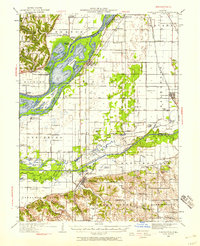
 1948 Havana1948 Print · USGSHavana and the Illinois River valley are captured here in the late 1940s, showing a landscape of river-bend settlements and archaeological sites. Genealogists and historians can trace Dickson Mounds State Park, Laurel Hill Cemetery, and rural schools like Nailrod Sch.2 unique versions available
 - 1948 Map of Mason City, 1963 Print
 1948 Mason City1963 Print · USGSCentral Illinois farming and rail life are at the forefront of this late 1940s survey. Genealogists and local historians can trace family-named sites like Johnson Valley Mine and North Sangamon Ch, alongside a dense network of rural schools.2 unique versions available
 - 1949 Map of Havana
 1949 Havana1949 Print · USGSThe Illinois River valley in the late 1940s reveals a landscape transitioning between coal mining and conservation. Genealogists and local historians can trace family roots through dozens of rural schools and landmarks like Dickson Mounds State Park, Mound Chapel, and the St Marys Cem near Lewistown.3 unique versions available
 - 1949 Map of Mason City
 1949 Mason City1949 Print · USGSCentral Illinois rail hubs and prairie farmsteads are captured here just after the war, showing the intersection of three major railroads. Genealogists can locate family landmarks like Honey Heart School, Johnson Valley Mine, and the Irish Grove Church.2 unique versions available
 - 1958 Map of Burlington, 1968 Print
 1958 Burlington1968 Print · USGSThe tri-state river country of Iowa, Illinois, and Missouri is captured here in the mid-fifties, dominated by the Mississippi River and major rail lines. Genealogists and historians can trace the development of river towns like Keokuk or locate the sprawling Iowa Army Ammunition Plant.4 unique versions available
 - 1958 Map of Peoria, 1969 Print
 1958 Peoria1969 Print · USGSCentral Illinois thrived as a hub of education and transport during the late sixties, as the new interstate system began to reshape the prairie. Genealogists and historians can trace local landmarks like Springdale Cem, Bradley University, and the sprawling grounds of Chanute AFB.4 unique versions available
 - 1961 Map of Burlington
 1961 Burlington1961 Print · USGSThe tri-state borderlands along the Mississippi River are captured here during the late fifties and early sixties, showing the vital river-and-rail economy of Iowa, Illinois, and Missouri. Genealogists and historians can trace the development of major hubs like Galesburg and Macomb alongside landmark sites such as the Iowa Ordnance Plant and the historic river town of Nauvoo.
 - 1961 Map of Peoria
 1961 Peoria1961 Print · USGSCentral Illinois thrived at the intersection of river trade and rail power during the late fifties. Genealogists and local historians can trace the rail networks of the Illinois Central and Wabash, alongside landmarks like Chanute AFB and Weldon Springs State Park.
 - 1963 Map of Burlington
 1963 Burlington1963 Print · USGSThe tri-state river country of the Mississippi and Illinois valleys comes alive in this mid-century survey. Genealogists and historians can trace the industrial and academic growth of the region, from the Iowa Ordnance Plant to campuses like Knox College and Western Illinois University.
 - 1963 Map of Peoria
 1963 Peoria1963 Print · USGSCentral Illinois thrived as a rail and highway crossroads during the early sixties, centered on the bustling Illinois River valley. Genealogists and historians can trace the mid-century layout of Peoria, locate the grounds of Chanute Air Force Base, and follow historic lines like the Toledo Peoria and Western Railway.
 - 1971 Map of Manito, 1973 Print
 1971 Manito1973 Print · USGSIn the early seventies, the central Illinois prairie around Manito was a landscape of managed waterways and state timberlands. Trace family ties and local rail history through the Chicago and Illinois Midland tracks and sites like St Frederick Cem and Forest City.2 unique versions available
 - 1971 Map of Oakford, 1973 Print
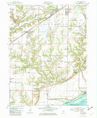
 1971 Oakford1973 Print · USGSIn the early seventies, the Menard County countryside around Oakford remained a landscape of prairie rail lines and deeply etched creek hollows. Researchers can locate numerous family-named landmarks and burial sites like Watkins Cem, Bobtown, and the Atterberry rail station.
Showing maps 1-25 of 160
Top cities of Mason County
- Havana historical maps
- Mason City historical maps
- Manito historical maps
- Easton historical maps
- Kilbourne historical maps
- Bath historical maps
See more
Frequently asked questions
- What are the different types of historical maps available for Mason County?
- What is the oldest map of Mason County?
- Where can I purchase historical maps of Mason County for my home or office?
- Where can I download high-res historical maps of Mason County?
- Are there historical topographic maps available for Mason County?
- Is there historical aerial imagery available for Mason County?
- Where are historical maps of Mason County sourced from?