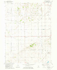
1980s Maps of Mason County, Illinois
Explore 17 historic maps of Mason County from the 1980s. These maps offer a rare glimpse into what life looked like during the 1980s — showing old roads, neighborhoods, homes, and landmarks that have changed or disappeared over time.
Whether you're researching your family's past, planning a metal detecting trip, or studying how Mason County's landscape evolved across the 1980s, these high-resolution maps are a powerful tool for exploring the history of this region.
- Focus on a specific era: All maps on this page are from the 1980s, giving you a focused view of this time period.
- See what’s changed: Compare century-old streets, trails, and buildings to today's modern landscape using overlays and satellite layers.
- Research with precision: Use these maps for genealogy, historical research, land use analysis, or educational projects.
- View, download, or print: Maps are fully viewable online in high resolution, and can be downloaded or printed for your own records.
Start exploring Mason County's history through authentic maps from the 1980s. This is your window into the past.
Mason County, IL maps
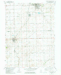
(17)- 1980 Map of Mason City
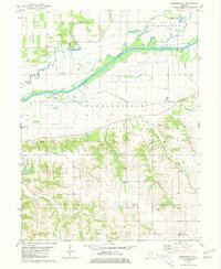
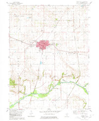 1980 Mason City1980 Print · USGSMason City stands at the crossing of two major rail lines in 1980, anchoring a landscape of fertile prairie and creek bottoms. Genealogists can locate family plots at Cherry Grove Cem or Swing Grove Cem, and trace the path of Salt Creek down to Hubly.
 - 1980 Map of New Holland
 1980 New Holland1980 Print · USGSNew Holland and the surrounding townships of Logan and Mason counties are shown here at the start of the 1980s. Researchers can trace old transit lines like the Old Railroad Grade or locate family sites at Stephens Cemetery and Pool Hill.
 - 1980 Map of Natrona
 1980 Natrona1980 Print · USGSThe rural borderlands of Mason and Tazewell counties are shown in the early 1980s, documenting a landscape of rail-connected hamlets and extensive prairie drainage. Genealogists and historians can locate family sites like Allens Grove Cem, Egypt Union Ch, and the settlement of Natrona.
 - 1980 Map of Delavan South
 1980 Delavan South1980 Print · USGSLogan, Mason, and Tazewell counties meet in this 1980 survey of the Illinois prairie during a period of established rail and drainage infrastructure. Researchers can pinpoint historic family sites at Prairie Rest Cem and Thomas Cem or trace the Illinois Central Gulf rail corridor.
 - 1981 Map of Astoria
 1981 Astoria1981 Print · USGSFulton and Schuyler counties are shown in the early eighties as a mix of river bottomlands and ridge-top farming communities. Genealogists can trace family names through the Price-Sackman Cem, Mud Valley Ch, and rural settlements like Sheldons Grove.
 - 1981 Map of Newmansville
 1981 Newmansville1981 Print · USGSCentral Illinois river country comes into focus in the early eighties as the Sangamon River winds past White City. Trace family history through rural sites like Mt Olive Ch and the Pontiac Cem near Newmansville.
 - 1981 Map of Kilbourne
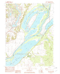
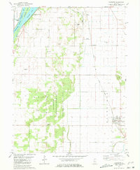 1981 Kilbourne1981 Print · USGSThe Illinois River valley and Mason County uplands are captured here in the early eighties as the region balanced agriculture with conservation. You can trace the Chicago and Illinois Midland rail line through Kilbourne or locate family sites at St Johns Cem and Deverman Cem.
 - 1981 Map of Chandlerville
 1981 Chandlerville1981 Print · USGSThe Sangamon River valley in the early 1980s reveals a patchwork of oxbow lakes, backwater sloughs, and high river bluffs. Researchers can trace rural aviation at Adkins Landing Strip, locate family history at Snicarte Cem, and explore the topography around Chandlerville.
 - 1981 Map of Clear Lake
 1981 Clear Lake1981 Print · USGSThe Sangamon River bottomlands of Cass County are shown here in the early 1980s, revealing an intricate landscape of sloughs and conservation areas. Researchers can trace local heritage through the Brick Sch and several pioneer-era cemeteries like Wells Cem and Beard Cem.
 - 1981 Map of Bath
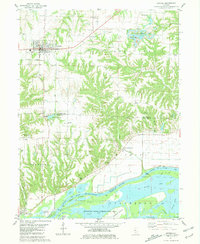
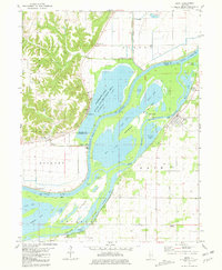 1981 Bath1981 Print · USGSThe Illinois River valley in the early 1980s is captured here in a detailed look at the wetland environments of Mason and Fulton Counties. Researchers can trace the old railroad grade near Bluff City or locate riverfront landmarks like Holmes Landing and the village of Bath.
 - 1982 Map of Topeka
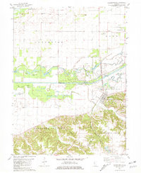
 1982 Topeka1982 Print · USGSThe Illinois River bottomlands and timbered uplands of Mason County come alive in this early 1980s survey. Researchers can trace the drainage networks of Biggs Ditch and find local landmarks like Buzzville, the State Tree Nursery, and Topeka.
 - 1982 Map of Forest City
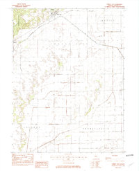 1982 Forest City1982 Print · USGSCentral Illinois farmland near the Mason and Tazewell County border is captured here in the early eighties. Genealogists and local historians can trace the irrigation network through Quiver Ditch and Mc Fadden Ditch or locate the rural settlement of Bishop.
 - 1982 Map of Duck Island
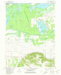
 1982 Duck Island1982 Print · USGSThe Illinois River valley in the early eighties shows a dense network of backwater lakes and wildlife refuges. Trace the layout of Liverpool or locate landmarks like Goofy Ridge, Duck Island, and the Strip Mine.
 - 1985 Map of Macomb
 1985 Macomb1985 Print · USGSWest Central Illinois in the mid-eighties shows a robust network of river towns and rail corridors spanning from the Illinois River to the Lamoine. Genealogists and historians can trace the foundations of Macomb, find rural landmarks like Pennington Point, or locate early conservation sites like Argyle Lake State Park.
 - 1985 Map of Lincoln
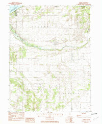
 1985 Lincoln1985 Print · USGSMid-century Illinois comes to life in this survey of Logan and Mason counties as the interstate era reshapes the prairie. Genealogists and historians can trace rail-town development from San Jose to Kenney or locate landmarks like Rose Hill Cem and Funks Grove.
 - 1989 Map of Macomb
 1989 Macomb1989 Print · USGSWest Central Illinois in the late eighties shows a landscape of river-bottom conservation and rail-town commerce. Researchers can trace the extensive wetlands of the Illinois River or locate historic transport hubs in Macomb, Colchester, and Beardstown.
 - 1989 Map of Lincoln
 1989 Lincoln1989 Print · USGSCentral Illinois in the late eighties remains a landscape of productive prairie and vital river arteries. Genealogists and local historians can trace rural family landmarks like Rose Hill Cem, identify early aviation at Logan County Airport, or follow the Illinois Central Gulf Railroad through towns like Atlanta and Lincoln.
End of results
Showing maps 1-17 of 17
Top cities of Mason County
- Havana historical maps
- Mason City historical maps
- Manito historical maps
- Easton historical maps
- Kilbourne historical maps
- Bath historical maps
See more
Frequently asked questions
- What are the different types of historical maps available for Mason County?
- What is the oldest map of Mason County?
- Where can I purchase historical maps of Mason County for my home or office?
- Where can I download high-res historical maps of Mason County?
- Are there historical topographic maps available for Mason County?
- Is there historical aerial imagery available for Mason County?
- Where are historical maps of Mason County sourced from?