1930s Maps of Tazewell County, Illinois
Explore 3 historic maps of Tazewell County from the 1930s. These maps offer a rare glimpse into what life looked like during the 1930s — showing old roads, neighborhoods, homes, and landmarks that have changed or disappeared over time.
Whether you're researching your family's past, planning a metal detecting trip, or studying how Tazewell County's landscape evolved across the 1930s, these high-resolution maps are a powerful tool for exploring the history of this region.
- Focus on a specific era: All maps on this page are from the 1930s, giving you a focused view of this time period.
- See what’s changed: Compare century-old streets, trails, and buildings to today's modern landscape using overlays and satellite layers.
- Research with precision: Use these maps for genealogy, historical research, land use analysis, or educational projects.
- View, download, or print: Maps are fully viewable online in high resolution, and can be downloaded or printed for your own records.
Start exploring Tazewell County's history through authentic maps from the 1930s. This is your window into the past.
Tazewell County, IL maps
(3)- 1930 Map of Glasford
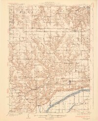 1930 Glasford1930 Print · USGSCentral Illinois river towns and upland prairie farms thrive in the late twenties between the Illinois River and Hanna City. Researchers can trace old coal operations at Baxter Mine or locate family roots at Penn Ridge Ch and Union Cemetery.3 unique versions available
 - 1932 Map of Mackinaw
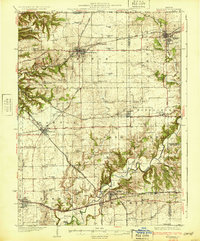 1932 Mackinaw1932 Print · USGSTazewell and Woodford counties are captured here in the early 1930s, showing a landscape tightly organized by rail lines and rural schoolhouses. Genealogists can trace family footprints across dozens of local districts like Cottonwood Sch or visit the Mennonite Ch and the Mackinaw Sanitarium.2 unique versions available
 - 1932 Map of Manito
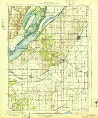 1932 Manito1932 Print · USGSThe Illinois River valley in the early 1930s showcases a landscape of intricate drainage ditches and river-bottom hunting clubs near Manito. Researchers can trace rural lineages through dozens of named sites like Eureka Sch, Ebenezer Ch, and Wessling Cem.3 unique versions available
End of results
Showing maps 1-3 of 3
Top cities of Tazewell County
- Pekin historical maps
- East Peoria historical maps
- Groveland historical maps
- Morton historical maps
- Washington historical maps
- Creve Coeur historical maps
See more
Frequently asked questions
- What are the different types of historical maps available for Tazewell County?
- What is the oldest map of Tazewell County?
- Where can I purchase historical maps of Tazewell County for my home or office?
- Where can I download high-res historical maps of Tazewell County?
- Are there historical topographic maps available for Tazewell County?
- Is there historical aerial imagery available for Tazewell County?
- Where are historical maps of Tazewell County sourced from?