1980s Maps of Tazewell County, Illinois
Explore 11 historic maps of Tazewell County from the 1980s. These maps offer a rare glimpse into what life looked like during the 1980s — showing old roads, neighborhoods, homes, and landmarks that have changed or disappeared over time.
Whether you're researching your family's past, planning a metal detecting trip, or studying how Tazewell County's landscape evolved across the 1980s, these high-resolution maps are a powerful tool for exploring the history of this region.
- Focus on a specific era: All maps on this page are from the 1980s, giving you a focused view of this time period.
- See what’s changed: Compare century-old streets, trails, and buildings to today's modern landscape using overlays and satellite layers.
- Research with precision: Use these maps for genealogy, historical research, land use analysis, or educational projects.
- View, download, or print: Maps are fully viewable online in high resolution, and can be downloaded or printed for your own records.
Start exploring Tazewell County's history through authentic maps from the 1980s. This is your window into the past.
Tazewell County, IL maps
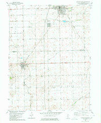
(11)- 1980 Map of Armington
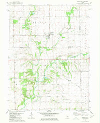 1980 Armington1980 Print · USGSThe rural borderlands of Tazewell and Logan counties are captured here in the late seventies. Family historians can trace several pioneer burial sites, including Oak View Cem and Miller Cem, alongside the Illinois Terminal rail line.
 - 1980 Map of Minier
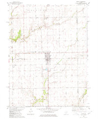 1980 Minier1980 Print · USGSTazewell County's rural landscape at the start of the eighties is centered on the rail junction at Minier. Researchers can trace old family sites and transport links through settlements like Mindale and Fravert, or locate burials at Broadway Cem and Camp Cem.
 - 1980 Map of Emden
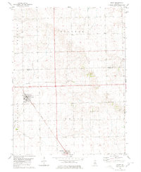 1980 Emden1980 Print · USGSThe Logan County agricultural corridor is captured here in the late 1970s, showcasing the rail-dependent layout of the Illinois prairie. Trace the historic route of the Illinois Central Gulf through Emden and Hartsburg, or find ancestral markers at Patterson Cemetery.
 - 1980 Map of Natrona
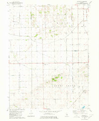 1980 Natrona1980 Print · USGSThe rural borderlands of Mason and Tazewell counties are shown in the early 1980s, documenting a landscape of rail-connected hamlets and extensive prairie drainage. Genealogists and historians can locate family sites like Allens Grove Cem, Egypt Union Ch, and the settlement of Natrona.
 - 1980 Map of Delavan South
 1980 Delavan South1980 Print · USGSLogan, Mason, and Tazewell counties meet in this 1980 survey of the Illinois prairie during a period of established rail and drainage infrastructure. Researchers can pinpoint historic family sites at Prairie Rest Cem and Thomas Cem or trace the Illinois Central Gulf rail corridor.
 - 1982 Map of Banner
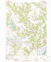 1982 Banner1982 Print · USGSThe Illinois River valley and its complex creek systems are recorded here during the early eighties. Genealogists and historians can trace the topography of Banner, Monterey, and Rawalts alongside significant water features like Copperas Creek and Canton Lake.
 - 1982 Map of Duck Island
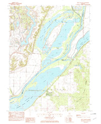 1982 Duck Island1982 Print · USGSThe Illinois River valley in the early eighties shows a dense network of backwater lakes and wildlife refuges. Trace the layout of Liverpool or locate landmarks like Goofy Ridge, Duck Island, and the Strip Mine.
 - 1985 Map of Peoria
 1985 Peoria1985 Print · USGSThe Illinois River valley and the Tri-County area are captured here in the mid-1980s as industry and infrastructure reshaped the heart of the state. Researchers can trace the grounds of Jubilee College, locate the Stark Mine near Elmwood, or follow the busy tracks of the Norfolk and Western Railroad.
 - 1985 Map of Lincoln
 1985 Lincoln1985 Print · USGSMid-century Illinois comes to life in this survey of Logan and Mason counties as the interstate era reshapes the prairie. Genealogists and historians can trace rail-town development from San Jose to Kenney or locate landmarks like Rose Hill Cem and Funks Grove.
 - 1989 Map of Lincoln
 1989 Lincoln1989 Print · USGSCentral Illinois in the late eighties remains a landscape of productive prairie and vital river arteries. Genealogists and local historians can trace rural family landmarks like Rose Hill Cem, identify early aviation at Logan County Airport, or follow the Illinois Central Gulf Railroad through towns like Atlanta and Lincoln.
 - 1989 Map of Peoria
 1989 Peoria1989 Print · USGSThe Illinois River valley thrived as a regional center of industry, education, and transport during the late eighties. Researchers can trace the extensive rail networks of the Peoria and Pekin Union Railway or locate landmarks like Bradley University and the Peoria Air National Guard Base.
End of results
Showing maps 1-11 of 11
Top cities of Tazewell County
- Pekin historical maps
- East Peoria historical maps
- Groveland historical maps
- Morton historical maps
- Washington historical maps
- Creve Coeur historical maps
See more
Frequently asked questions
- What are the different types of historical maps available for Tazewell County?
- What is the oldest map of Tazewell County?
- Where can I purchase historical maps of Tazewell County for my home or office?
- Where can I download high-res historical maps of Tazewell County?
- Are there historical topographic maps available for Tazewell County?
- Is there historical aerial imagery available for Tazewell County?
- Where are historical maps of Tazewell County sourced from?