1970s Maps of Tazewell County, Illinois
Explore 9 historic maps of Tazewell County from the 1970s. These maps offer a rare glimpse into what life looked like during the 1970s — showing old roads, neighborhoods, homes, and landmarks that have changed or disappeared over time.
Whether you're researching your family's past, planning a metal detecting trip, or studying how Tazewell County's landscape evolved across the 1970s, these high-resolution maps are a powerful tool for exploring the history of this region.
- Focus on a specific era: All maps on this page are from the 1970s, giving you a focused view of this time period.
- See what’s changed: Compare century-old streets, trails, and buildings to today's modern landscape using overlays and satellite layers.
- Research with precision: Use these maps for genealogy, historical research, land use analysis, or educational projects.
- View, download, or print: Maps are fully viewable online in high resolution, and can be downloaded or printed for your own records.
Start exploring Tazewell County's history through authentic maps from the 1970s. This is your window into the past.
Tazewell County, IL maps
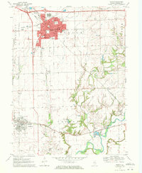
(9)- 1970 Map of Washington, 1972 Print
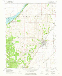
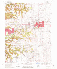 1970 Washington1972 Print · USGSTazewell County's expansion is clearly visible in the early seventies as the residential edges of WASHINGTON and MORTON begin to spread across the Illinois prairie. Researchers can trace family history through numerous rural burial sites like Guth Cem and Herstein Cem or locate local landmarks like the Smitty Landing Strip.2 unique versions available
 - 1970 Map of Eureka, 1972 Print
 1970 Eureka1972 Print · USGSWoodford and Tazewell counties are shown in the early seventies as established rail and college communities. Trace local family roots through Hartman Cem and Mt Zion Cem or follow the rails of the Toledo Peoria and Western.2 unique versions available
 - 1970 Map of Mackinaw, 1972 Print
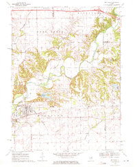 1970 Mackinaw1972 Print · USGSTazewell County's rural heartland is documented here in the early seventies, centered on the Penn Central rail corridor and the winding Mackinaw River. Genealogists and historians can locate the Oak Knoll Sanatorium, old family burials like Stumbaugh Cem, and the small settlement of Lilly.2 unique versions available
 - 1970 Map of Morton, 1972 Print
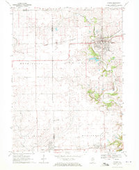
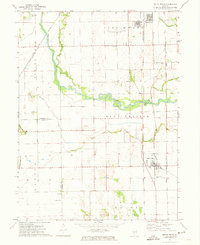
 1970 Morton1972 Print · USGSTazewell County in the early seventies shows the expansion of Morton alongside its long-standing rail networks. Local historians can trace old community landmarks from Allentown to rural burial sites like Buckeye Cem and Walnut Cem.2 unique versions available
 - 1971 Map of Manito, 1973 Print
 1971 Manito1973 Print · USGSIn the early seventies, the central Illinois prairie around Manito was a landscape of managed waterways and state timberlands. Trace family ties and local rail history through the Chicago and Illinois Midland tracks and sites like St Frederick Cem and Forest City.2 unique versions available
 - 1971 Map of South Pekin, 1973 Print
 1971 South Pekin1973 Print · USGSCentral Illinois farming and rail life are preserved here in the early seventies, centered on the villages of South Pekin and Green Valley. Genealogists and historians can trace family roots at Old Sand Prairie Cem or locate old rural landmarks like Union Ch and The Mound.2 unique versions available
 - 1971 Map of Delavan North, 1973 Print
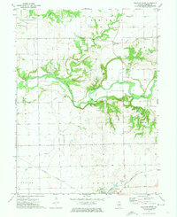 1971 Delavan North1973 Print · USGSCentral Illinois farmland and the winding Mackinaw River define this Tazewell County landscape in the early seventies. Genealogists and historians can locate old burial grounds like Dillon Cem and trace the paths of the Illinois Central and Gulf Mobile and Ohio railroads.
 - 1971 Map of Hopedale, 1973 Print
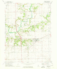 1971 Hopedale1973 Print · USGSHopedale and the surrounding central Illinois countryside are captured in the early seventies, centered on the Mackinaw River. Genealogists can locate numerous local burial sites including Mennonite Cem and Orendorff Cem along the Gulf Mobile and Ohio rail line.
 - 1971 Map of Glasford, 1974 Print
 1971 Glasford1974 Print · USGSThe Illinois River valley in the early 1970s reveals a landscape defined by heavy industry and small-town roots. Researchers can trace local genealogy through Lancaster Cem and Union Cem, or explore the industrial riverfront near Kingston Mines.
End of results
Showing maps 1-9 of 9
Top cities of Tazewell County
- Pekin historical maps
- East Peoria historical maps
- Groveland historical maps
- Morton historical maps
- Washington historical maps
- Creve Coeur historical maps
See more
Frequently asked questions
- What are the different types of historical maps available for Tazewell County?
- What is the oldest map of Tazewell County?
- Where can I purchase historical maps of Tazewell County for my home or office?
- Where can I download high-res historical maps of Tazewell County?
- Are there historical topographic maps available for Tazewell County?
- Is there historical aerial imagery available for Tazewell County?
- Where are historical maps of Tazewell County sourced from?