1920s Maps of Tazewell County, Illinois
Explore 3 historic maps of Tazewell County from the 1920s. These maps offer a rare glimpse into what life looked like during the 1920s — showing old roads, neighborhoods, homes, and landmarks that have changed or disappeared over time.
Whether you're researching your family's past, planning a metal detecting trip, or studying how Tazewell County's landscape evolved across the 1920s, these high-resolution maps are a powerful tool for exploring the history of this region.
- Focus on a specific era: All maps on this page are from the 1920s, giving you a focused view of this time period.
- See what’s changed: Compare century-old streets, trails, and buildings to today's modern landscape using overlays and satellite layers.
- Research with precision: Use these maps for genealogy, historical research, land use analysis, or educational projects.
- View, download, or print: Maps are fully viewable online in high resolution, and can be downloaded or printed for your own records.
Start exploring Tazewell County's history through authentic maps from the 1920s. This is your window into the past.
Tazewell County, IL maps
(3)- 1927 Map of Peoria, 1955 Print
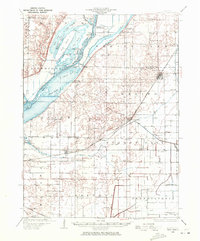
 1927 Peoria1955 Print · USGSPeoria and the Illinois River valley are shown here during the mid-1930s, capturing a critical era of rail expansion and industrial growth. Genealogists and researchers can trace local landmarks like the State Hospital, Orchard Mines, and the Poor Farm.
 - 1928 Map of Mackinaw, 1954 Print
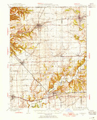 1928 Mackinaw1954 Print · USGSTazewell and Woodford Counties thrived as a major rail hub in the late twenties, balancing rich farmland with bustling rail towns. Genealogists can trace family roots through dozens of district schools like Science Hill Sch and settlements including Morton, Deer Creek, and Allentown.
 - 1929 Map of Manito, 1972 Print
 1929 Manito1972 Print · USGSMason and Fulton counties in the late 1920s reveal a landscape of deep river bottoms and newly drained prairie. Researchers can trace family history through a dense network of country schools and churches like Coon Sch and Macedonia Ch, or locate the path of the Chicago and Illinois Midland railway.
End of results
Showing maps 1-3 of 3
Top cities of Tazewell County
- Pekin historical maps
- East Peoria historical maps
- Groveland historical maps
- Morton historical maps
- Washington historical maps
- Creve Coeur historical maps
See more
Frequently asked questions
- What are the different types of historical maps available for Tazewell County?
- What is the oldest map of Tazewell County?
- Where can I purchase historical maps of Tazewell County for my home or office?
- Where can I download high-res historical maps of Tazewell County?
- Are there historical topographic maps available for Tazewell County?
- Is there historical aerial imagery available for Tazewell County?
- Where are historical maps of Tazewell County sourced from?