1970s Maps of Scott County, Kansas
Explore 20 historic maps of Scott County from the 1970s. These maps offer a rare glimpse into what life looked like during the 1970s — showing old roads, neighborhoods, homes, and landmarks that have changed or disappeared over time.
Whether you're researching your family's past, planning a metal detecting trip, or studying how Scott County's landscape evolved across the 1970s, these high-resolution maps are a powerful tool for exploring the history of this region.
- Focus on a specific era: All maps on this page are from the 1970s, giving you a focused view of this time period.
- See what’s changed: Compare century-old streets, trails, and buildings to today's modern landscape using overlays and satellite layers.
- Research with precision: Use these maps for genealogy, historical research, land use analysis, or educational projects.
- View, download, or print: Maps are fully viewable online in high resolution, and can be downloaded or printed for your own records.
Start exploring Scott County's history through authentic maps from the 1970s. This is your window into the past.
Scott County, KS maps
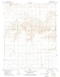
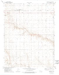
(20)- 1974 Map of Amy SW, 1976 Print
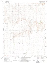
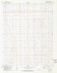
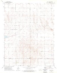 1974 Amy SW1976 Print · USGSWestern Kansas at the start of the seventies reveals a landscape of high-plains agriculture and mineral extraction across the borders of three counties. Genealogists and historians can trace the rural layout of Pleasant Valley or locate local landmarks like Dry Lake and the Caliche Pits.
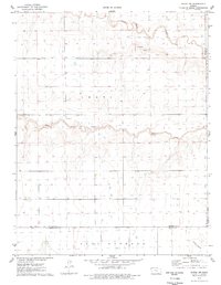
 - 1974 Map of Healy NW, 1976 Print
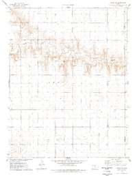
 1974 Healy NW1976 Print · USGSThe Smoky Hill River valley and the western Kansas high plains are documented here in the mid-1970s. Researchers can trace the drainage networks of Hell Creek and West Salt Creek or locate local mineral resources like the Caliche Pits.
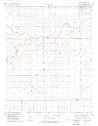
 - 1974 Map of Grigston, 1976 Print
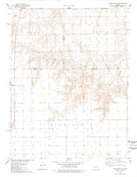
 1974 Grigston1976 Print · USGSWestern Kansas agricultural and industrial life is captured here in the mid-1970s, as the High Plains landscape supported both cattle and energy. Researchers can trace the Atchison Topeka and Santa Fe rail line through Grigston or locate specific Oil Wells and a large Feedlot.
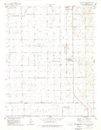
 - 1974 Map of Manning, 1977 Print
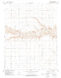
 1974 Manning1977 Print · USGSMid-century western Kansas unfolds here during the 1970s, showcasing the high plains agriculture of the Scott and Lane County line. Researchers can trace the railroad legacy of Manning along the Missouri Pacific or locate early industrial sites like the Caliche Pits.
 - 1976 Map of Lake Scott, 1978 Print
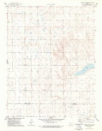
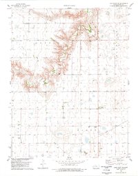
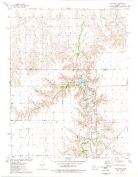 1976 Lake Scott1978 Print · USGSWestern Kansas canyon country comes to life in the mid-seventies, showing the deep draws and springs that provided rare refuge on the plains. Genealogists and historians can locate the El Cuartelejo Ruins, White Womans Grave, and the site of an Old Railroad Grade.
 - 1976 Map of Pence, 1978 Print
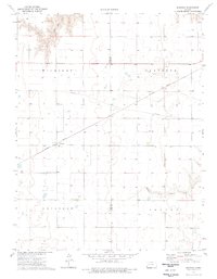
 1976 Pence1978 Print · USGSScott County and Logan County were largely defined by rural townships and agricultural industry in the mid-1970s. Genealogists can locate family landmarks like Pence Cem and Scott Ch near the historic settlement of Pence.
 - 1976 Map of Modoc SW, 1978 Print
 1976 Modoc SW1978 Print · USGSWichita County in the late 1970s shows a landscape of wide-open plains and seasonal drainages. Genealogists and local historians can locate the Lydia Ch and Cem near the county line, while tracing the paths of White Woman Creek and Sand Creek.
 - 1976 Map of Modoc SE, 1978 Print
 1976 Modoc SE1978 Print · USGSWestern Kansas land use comes into focus in the mid-1970s, showing a landscape defined by watercourses and energy infrastructure. Researchers can trace the path of White Woman Creek or locate local landmarks like East Hibbard and the regional Oil Field.
 - 1976 Map of Shallow Water, 1978 Print
 1976 Shallow Water1978 Print · USGSWestern Kansas during the mid-seventies shows a landscape of high-plains agriculture and rising energy production. Genealogists and local historians can trace the rural infrastructure of Shallow Water and Friend, from the Prairie View Ch to the industrial Refinery and sprawling Oil Field.
 - 1976 Map of Pence NW, 1978 Print
 1976 Pence NW1978 Print · USGSWestern Kansas at the height of the 1970s shows a landscape of agricultural utility and aviation transit at the county lines. Trace local infrastructure through private aviation sites like Kough Landing Strip and the winding course of Chalk Creek.
 - 1976 Map of Modoc, 1978 Print
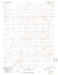
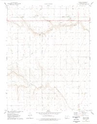 1976 Modoc1978 Print · USGSScott County, Kansas, is captured in the mid-seventies, showing the high plains landscape and the vital rail corridor through Modoc. Genealogists and historians can trace the townsite at Modoc Cem and the path of the Missouri Pacific railroad.
 - 1976 Map of Pawnee Mound, 1978 Print
 1976 Pawnee Mound1978 Print · USGSWestern Kansas at the end of the seventies reveals a landscape of high-plains relief and seasonal basins. Researchers can trace the boundary between Scott Co and Finney Co while locating landmarks like Pawnee Mound and the basin of Dry Lake.
 - 1976 Map of Scott City, 1978 Print
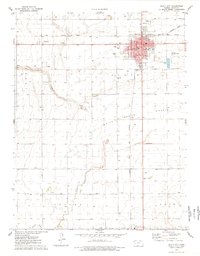 1976 Scott City1978 Print · USGSScott City was a thriving rail and agricultural center in the mid-1970s, where two major lines met on the High Plains. Genealogists and local historians can trace civic life through the Courthouse and St Joseph Sch, or locate rural landmarks like Shallow Water and the Scott City Cem.
 - 1976 Map of Marienthal, 1978 Print
 1976 Marienthal1978 Print · USGSMarienthal and the surrounding High Plains are captured here during the mid-seventies, showing a landscape defined by the Missouri Pacific railroad. Genealogists and local historians can locate St Marys Cem and trace the deep drainage of Rocky Draw as it cuts through the prairie.
 - 1976 Map of Pence SW, 1978 Print
 1976 Pence SW1978 Print · USGSWichita County and the Leoti township area are captured here during the mid-seventies, showing the rural Kansas landscape before modern shifts. Researchers can trace the winding path of Ladder Creek and locate early resource sites like the Gravel Pit and scattered Wells.
 - 1976 Map of Lake Scott NE, 1978 Print
 1976 Lake Scott NE1978 Print · USGSWestern Kansas at the mid-seventies reveals a landscape of high-plains agriculture and emerging energy sites. Genealogists and local historians can trace family land via field lines near Ryan, visit the Keystone Cem, and follow the seasonal flow of Hell Creek.
 - 1978 Map of Pence SE
 1978 Pence SE1978 Print · USGSWestern Kansas ranching and agriculture define the landscape of Beaver and Isbel townships in the late seventies. Researchers can trace land use patterns through features like Ladder Creek, scattered irrigation wells, and localized Gravel Pits.
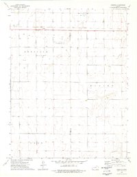
 - 1978 Map of Tractor
 1978 Tractor1978 Print · USGSRailroad lines and prairie basins defined this Scott County landscape in the late seventies. Genealogists and historians can trace the intersection of the Atchison Topeka and Santa Fe near Tractor or locate industrial sites like the White Woman Basin oil and gas wells.
 - 1978 Map of Lake Scott SE
 1978 Lake Scott SE1978 Print · USGSWestern Kansas at the end of the 1970s reveals a landscape organized by rail and energy infrastructure. Researchers can trace the path of the Missouri Pacific railroad as it passes near the Feedlot and numerous regional Oil Wells.
 - 1978 Map of Lake Scott SW
 1978 Lake Scott SW1978 Print · USGSScott County and the western Kansas plains are captured in the late seventies as industrial farming and local aviation shaped the land. Researchers can trace rural landmarks like Beaver Flats Sch, the Buehler Airfield, and the winding course of Ladder Creek.
End of results
Showing maps 1-20 of 20
Top cities of Scott County
Frequently asked questions
- What are the different types of historical maps available for Scott County?
- What is the oldest map of Scott County?
- Where can I purchase historical maps of Scott County for my home or office?
- Where can I download high-res historical maps of Scott County?
- Are there historical topographic maps available for Scott County?
- Is there historical aerial imagery available for Scott County?
- Where are historical maps of Scott County sourced from?