1970s Maps of Breckinridge County, Kentucky
Explore 4 historic maps of Breckinridge County from the 1970s. These maps offer a rare glimpse into what life looked like during the 1970s — showing old roads, neighborhoods, homes, and landmarks that have changed or disappeared over time.
Whether you're researching your family's past, planning a metal detecting trip, or studying how Breckinridge County's landscape evolved across the 1970s, these high-resolution maps are a powerful tool for exploring the history of this region.
- Focus on a specific era: All maps on this page are from the 1970s, giving you a focused view of this time period.
- See what’s changed: Compare century-old streets, trails, and buildings to today's modern landscape using overlays and satellite layers.
- Research with precision: Use these maps for genealogy, historical research, land use analysis, or educational projects.
- View, download, or print: Maps are fully viewable online in high resolution, and can be downloaded or printed for your own records.
Start exploring Breckinridge County's history through authentic maps from the 1970s. This is your window into the past.
Breckinridge County, KY maps
(4)- 1970 Map of Alton, 1972 Print
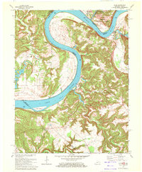 1970 Alton1972 Print · USGSThe Ohio River meanders between Indiana and Kentucky in the 1970s, shaping the life of riverfront towns and upland forests. Genealogists and historians can trace riverside settlements like Alton and Concordia, or find family landmarks such as St Theresa Academy and Owens Cem.
 - 1970 Map of Cloverport, 1972 Print
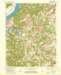
 1970 Cloverport1972 Print · USGSThe banks of the Ohio River in the early 1970s reveal a mix of river-town industry and rural ridge-top life. Genealogists and historians can trace old homesteads and landmarks near Cloverport, Patesville, and the Harris Memorial Cemetery.2 unique versions available
 - 1970 Map of Rome, 1972 Print
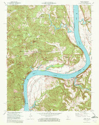 1970 Rome1972 Print · USGSThe banks of the Ohio River define this 1970s landscape where Perry County, Indiana meets Breckinridge County, Kentucky. Genealogists can trace family heritage through numerous hillside sites like St Peters Ch and Maier Cem, or locate the riverfront rail stops at Stephensport and Addison.
 - 1970 Map of Mattingly, 1972 Print
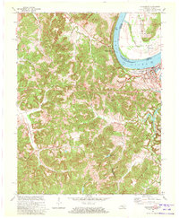
 1970 Mattingly1972 Print · USGSBreckinridge County sits along the Ohio River during the early seventies, centered on the historic rail town of Cloverport. Local historians can trace family ties at rural landmarks like Mattingly, New Bethel Ch, and the Chapin Cem.2 unique versions available
End of results
Showing maps 1-4 of 4
Top cities of Breckinridge County
Frequently asked questions
- What are the different types of historical maps available for Breckinridge County?
- What is the oldest map of Breckinridge County?
- Where can I purchase historical maps of Breckinridge County for my home or office?
- Where can I download high-res historical maps of Breckinridge County?
- Are there historical topographic maps available for Breckinridge County?
- Is there historical aerial imagery available for Breckinridge County?
- Where are historical maps of Breckinridge County sourced from?