1990s Maps of Breckinridge County, Kentucky
Explore 11 historic maps of Breckinridge County from the 1990s. These maps offer a rare glimpse into what life looked like during the 1990s — showing old roads, neighborhoods, homes, and landmarks that have changed or disappeared over time.
Whether you're researching your family's past, planning a metal detecting trip, or studying how Breckinridge County's landscape evolved across the 1990s, these high-resolution maps are a powerful tool for exploring the history of this region.
- Focus on a specific era: All maps on this page are from the 1990s, giving you a focused view of this time period.
- See what’s changed: Compare century-old streets, trails, and buildings to today's modern landscape using overlays and satellite layers.
- Research with precision: Use these maps for genealogy, historical research, land use analysis, or educational projects.
- View, download, or print: Maps are fully viewable online in high resolution, and can be downloaded or printed for your own records.
Start exploring Breckinridge County's history through authentic maps from the 1990s. This is your window into the past.
Breckinridge County, KY maps
(11)- 1991 Map of Tell City
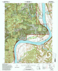
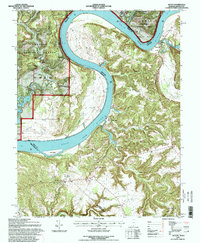
 1991 Tell City1991 Print · USGSThe Ohio River valley at the start of the nineties reveals a landscape of riverfront industry and sprawling conservation lands. Genealogists can locate family landmarks like Wesley Chapel and rural communities such as Reynolds Station and Maceo.
 - 1991 Map of Big Spring, 1992 Print
 1991 Big Spring1992 Print · USGSBreckinridge and Meade counties meet in this rural Kentucky landscape during the early nineties. Genealogists and local historians can trace family roots through sites like Bennett Cem, the settlement of Bewleyville, and the tri-county junction at Big Spring.
 - 1991 Map of Guston, 1992 Print
 1991 Guston1992 Print · USGSMeade County at the start of the nineties reveals a landscape of plateau settlements and rural crossroads. Local historians can trace family roots at Cap Anderson Cem or explore the community centers at Ekron, Guston, and Weldon Ch.
 - 1991 Map of Constantine, 1992 Print
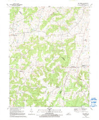
 1991 Constantine1992 Print · USGSThe rolling uplands of Kentucky at the close of the twentieth century reveal a landscape of family farms and historic river crossings. Genealogists can locate rural landmarks like Pierce Mill, Memorial Chapel, and the isolated Pole Bridge Ch Cem.
 - 1993 Map of Kingswood, 1996 Print
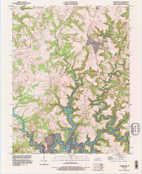 1993 Kingswood1996 Print · USGSBreckinridge County's winding waterways and rural crossroads are captured here in the early nineties. Genealogists and local historians can trace the intricate shoreline of Rough River Lake and locate community landmarks near Kingswood, Westview, and Axtel.
 - 1993 Map of Hardinsburg, 1996 Print
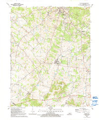
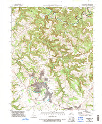 1993 Hardinsburg1996 Print · USGSHardinsburg and the surrounding Breckinridge County countryside are captured here in the early nineties, showing a mix of established town life and rural valley settlements. Local historians can trace family roots near Clifton Mills, Codyville, and numerous rural cemeteries.
 - 1993 Map of Glen Dean, 1996 Print
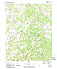
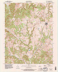 1993 Glen Dean1996 Print · USGSBreckinridge County is shown in detail during the early 1990s, capturing a rural landscape of ridges and winding creek beds. Researchers can locate small crossroads and landmarks such as Glen Dean, Vanzant, and the historic St Marys Cem.
 - 1993 Map of Rome, 1996 Print
 1993 Rome1996 Print · USGSThe Ohio River valley in the early 1990s reveals a landscape defined by the winding border between Indiana and Kentucky. Researchers can trace rural lineages through family burial sites like Lamb Cem and Connor Cem, or explore the riverside towns of Rome and Stephensport.
 - 1993 Map of Derby, 1998 Print
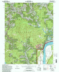 1993 Derby1998 Print · USGSThe banks of the Ohio River meet the deep woods of the Hoosier National Forest in the 1990s. Researchers can locate local landmarks like St Augustine Ch, the Elder Sch, and several rural burial grounds such as Badger Cem.
 - 1993 Map of Alton, 1998 Print
 1993 Alton1998 Print · USGSThe Ohio River loops between Indiana and Kentucky in the early nineties, revealing a rugged borderland of high bluffs and deep creek hollows. Researchers can locate small riverside settlements like Magnet and Concordia, or trace family sites such as Barr Cem and the St Theresa Academy.
 - 1994 Map of Jasper
 1994 Jasper1994 Print · USGSSouthern Indiana and the Kentucky borderlands are captured here in the mid-nineties, showing a landscape defined by the Ohio River and dense state forests. Genealogists can locate family landmarks like Saint Meinrad Archabbey, Saint Anthony, and the historic Lincoln Boyhood National Memorial.
End of results
Showing maps 1-11 of 11
Top cities of Breckinridge County
Frequently asked questions
- What are the different types of historical maps available for Breckinridge County?
- What is the oldest map of Breckinridge County?
- Where can I purchase historical maps of Breckinridge County for my home or office?
- Where can I download high-res historical maps of Breckinridge County?
- Are there historical topographic maps available for Breckinridge County?
- Is there historical aerial imagery available for Breckinridge County?
- Where are historical maps of Breckinridge County sourced from?