1930s Maps of Pulaski County, Kentucky
Explore 2 historic maps of Pulaski County from the 1930s. These maps offer a rare glimpse into what life looked like during the 1930s — showing old roads, neighborhoods, homes, and landmarks that have changed or disappeared over time.
Whether you're researching your family's past, planning a metal detecting trip, or studying how Pulaski County's landscape evolved across the 1930s, these high-resolution maps are a powerful tool for exploring the history of this region.
- Focus on a specific era: All maps on this page are from the 1930s, giving you a focused view of this time period.
- See what’s changed: Compare century-old streets, trails, and buildings to today's modern landscape using overlays and satellite layers.
- Research with precision: Use these maps for genealogy, historical research, land use analysis, or educational projects.
- View, download, or print: Maps are fully viewable online in high resolution, and can be downloaded or printed for your own records.
Start exploring Pulaski County's history through authentic maps from the 1930s. This is your window into the past.
Pulaski County, KY maps
(2)- 1932 Map of Burnside
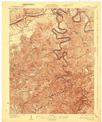 1932 Burnside1932 Print · USGSThe Cumberland River and its South Fork are captured here in the early 1930s, showing the intricate river-and-rail topography of southern Kentucky. Researchers can locate dozens of country landmarks like Roberts Mill, Lovells Chapel, and Pole Bridge Sch.2 unique versions available
 - 1935 Map of Somerset
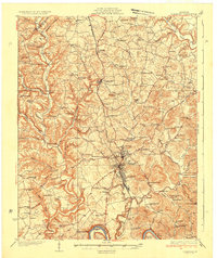 1935 Somerset1935 Print · USGSIn the mid-1930s, the rural landscapes around Somerset were a dense network of one-room schools and river crossings. Genealogists can trace family connections through numerous landmarks like Mt Zion Sch, Waitsboro Ferry, and the Mills Springs National Cem.
End of results
Showing maps 1-2 of 2
Top cities of Pulaski County
- Somerset historical maps
- Ferguson historical maps
- Burnside historical maps
- Science Hill historical maps
- Eubank historical maps
Frequently asked questions
- What are the different types of historical maps available for Pulaski County?
- What is the oldest map of Pulaski County?
- Where can I purchase historical maps of Pulaski County for my home or office?
- Where can I download high-res historical maps of Pulaski County?
- Are there historical topographic maps available for Pulaski County?
- Is there historical aerial imagery available for Pulaski County?
- Where are historical maps of Pulaski County sourced from?