Old Maps of Wabaunsee County, Kansas
Explore 202 old maps of Wabaunsee County, spanning from 1885 to today. These high-resolution historic maps reveal how streets, neighborhoods, landmarks, and natural features evolved over time — perfect for genealogy, metal detecting, research, and local history exploration.
What you can do with these maps:
- See how Wabaunsee County changed over time: Compare historical maps to modern-day views to trace roads, homesites, rail lines & more.
- View detailed metadata: Each map includes creators, publishers, year, scale, and archive source.
- Overlay maps with satellite & LiDAR: Visualize the past alongside modern tools to explore terrain & human change.
- Trusted historical sources: Maps sourced from the USGS, Library of Congress, and other archives.
- Access maps your way: View online, download high-res files, or order prints for personal or research use.
Start exploring old maps of Wabaunsee County to uncover forgotten places, hidden landmarks, and the deep history beneath your feet.
Wabaunsee County, KS maps
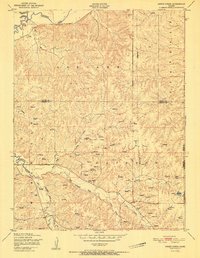
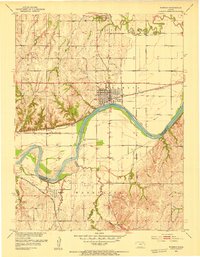
(202)- 1885 Map of Eskridge
 1885 Eskridge1885 Print · USGSEast-central Kansas was a hub of rapid railroad expansion in the 1880s, where iron rails began to define the prairie landscape. Genealogists and historians can trace the early layout of Council Grove and find now-quiet settlements like Bismarck and Admire City.
 - 1886 Map of Junction City, 1960 Print
 1886 Junction City1960 Print · USGSNortheastern Kansas in the late nineteenth century centers on the strategic military and rail hubs of the Flint Hills. Genealogists can trace the early foundations of Junction City, the sprawling Fort Riley Military Reservation, and rail-stop towns like Garrison and Stockdale.
 - 1889 Map of Burlingame
 1889 Burlingame1889 Print · USGSOsage and Shawnee Counties are seen here during the peak of late-Victorian rail expansion and coal-country growth. Genealogists and local historians can trace early township boundaries and the development of rail hubs like Osage City, Burlingame, and the settlement of Arvonia.
 - 1889 Map of Wamego
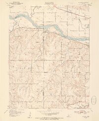
 1889 Wamego1889 Print · USGSNortheastern Kansas thrives along the river valleys in the 1880s, where rail networks and river crossings dictated the growth of the prairie. Genealogists can trace family roots in early hubs like Alma, St Marys, and Wamego, or find the path of the Union Pacific Railroad.
 - 1889 Map of Junction City
 1889 Junction City1889 Print · USGSThe confluence of the Republican and Smoky Hill rivers defines this central Kansas landscape in the late nineteenth century. Genealogists and historians can trace the early footprints of Fort Riley, the rail hubs of Junction City and Manhattan, and vanished stops like Garrison and Bala.
 - 1889 Map of Parkerville
 1889 Parkerville1889 Print · USGSMorris and Marion County townships appear here during the great western rail boom. Genealogists and historians can trace the early layouts of Parkerville, White City, and Herrington along the Chicago Kansas and Nebraska Railroad.
 - 1889 Map of Eskridge
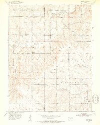
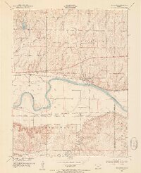
 1889 Eskridge1889 Print · USGSKansas prairie life in the late 1880s is defined here by the rapid arrival of the iron horse across Wabaunsee and Lyon counties. Genealogists and historians can trace early rail hubs like Council Grove and Eskridge, or follow the winding path of One Hundred and Forty Two Mile Creek.
 - 1889 Map of Topeka
 1889 Topeka1889 Print · USGSEastern Kansas in the late nineteenth century was a landscape of rapid rail expansion and tribal land boundaries. Genealogists can trace family roots through the Pottawatomie Indian Reservation or old settlements like Holton, Rossville, and Agency.
 - 1894 Map of Eskridge
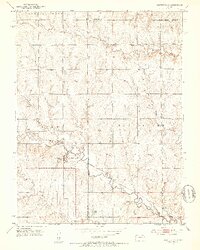
 1894 Eskridge1894 Print · USGSEast-central Kansas was a bustling corridor of competing railroads and growing prairie towns in the decade before the turn of the century. Genealogists and local historians can trace the early footprints of Council Grove and Eskridge, alongside smaller locales like Dunlap and Agnes City.5 unique versions available
 - 1894 Map of Junction City
 1894 Junction City1894 Print · USGSThe Kansas frontier of the late nineteenth century comes alive as the rail-and-river network expands around Junction City. Genealogists and historians can trace early townships and rural outposts like Riley Center, Bala, and the Fort Riley Military Reservation.7 unique versions available
 - 1894 Map of Burlingame
 1894 Burlingame1894 Print · USGSOsage County was a thriving rail and coal hub in the late nineteenth century, dominated by the intersecting tracks of major regional carriers. Researchers can trace the development of early Kansas towns like Scranton, Carbondale, and the river community of Quenemo.4 unique versions available
 - 1894 Map of Topeka
 1894 Topeka1894 Print · USGSTopeka and its northern reaches are captured here in the late nineteenth century, during a pivotal era of rail expansion and settlement. Local historians can trace the early layouts of Topeka and Silver Lake alongside the Pottawatomie Indian Reservation.5 unique versions available
 - 1894 Map of Parkerville
 1894 Parkerville1894 Print · USGSEastern Kansas at the height of the steam era shows a landscape transformed by competing rail lines and growing prairie towns. Genealogists and historians can trace early settlements like White City, Parkerville, and the riverside hub of Council Grove.6 unique versions available
 - 1894 Map of Wamego
 1894 Wamego1894 Print · USGSThe Kansas prairie in the late nineteenth century was a world of steam and river crossings, where the iron horse reshaped the frontier. Genealogists can trace family roots in established towns like Wamego, Alma, or the small settlement of Moodyville along Rock Creek.5 unique versions available
 - 1947 Map of Manhattan, 1954 Print
 1947 Manhattan1954 Print · USGSManhattan and the surrounding Kansas river valleys are shown here in the years immediately following World War II. Researchers can trace the extensive military works at Camp Funston, local education at College Hill Sch, and pioneer-era sites like St Patricks Cem.2 unique versions available
 - 1947 Map of Lawrence, 1954 Print
 1947 Lawrence1954 Print · USGSEastern Kansas and western Missouri thrive in the late 1940s, showing a landscape defined by major river valleys and a dense railway network. Genealogists can trace family settlements from Lawrence to Greenwood and locate landmarks like Olathe Navy and Lake Lotawana.
 - 1950 Map of Kansas City
 1950 Kansas City1950 Print · USGSMid-century Kansas and Missouri are captured here during a period of industrial growth and shifting transportation. Genealogists and historians can trace rail lines like the Wabash RR or locate ancestral homes near the Potawatomi Indian Reservation and Horton.
 - 1950 Map of Lawrence
 1950 Lawrence1950 Print · USGSMid-century Kansas and Missouri come alive in this map of the river-valley corridors just as the interstate era was beginning. Researchers can trace the legacy of major rail lines like the Union Pacific RR and locate ancestral roots in towns from Lawrence to Harrisonville.
 - 1951 Map of Swede Creek
 1951 Swede Creek1951 Print · USGSThe rural borderlands of Geary and Riley counties are captured here in the early fifties, showing a landscape shaped by the McDowell Creek watershed. Researchers can trace family history through sites like Ashland Cemetery, Briggs School, and Cleveland School.2 unique versions available
 - 1952 Map of Rossville, 1953 Print
 1952 Rossville1953 Print · USGSThe rural borders of Shawnee and Jackson counties are captured here in the early fifties, a time when small country schoolhouses still dotted the prairie. You can trace family roots at Bohemian Cemetery, locate the Stone School, or follow the Union Pacific rail line.4 unique versions available
 - 1952 Map of Harveyville, 1953 Print
 1952 Harveyville1953 Print · USGSHarveyville and the surrounding prairie were captured in the early fifties as the local rail-and-water economy thrived. Genealogists and historians can trace the Atchison Topeka and Santa Fe line, the Bellview Sch (Abandoned), and the Cem north of town.3 unique versions available
 - 1952 Map of Dover, 1953 Print
 1952 Dover1953 Print · USGSShawnee County at the start of the fifties shows a landscape defined by old reservation lines and winding creek beds. Researchers can find numerous former local landmarks, including School No 6 (Abandoned), the Dover Cem, and the Girl Scout Camp near Mission Creek.3 unique versions available
 - 1952 Map of Willard, 1954 Print
 1952 Willard1954 Print · USGSThe Kansas River valley at mid-century reveals a bustling corridor of competing rail lines and riverfront settlements. Researchers can trace the legacy of family farms and rural communities through landmarks like West Union Ch, Green Cem, and the Valencia townsite.4 unique versions available
 - 1953 Map of Wamego, 1954 Print
 1953 Wamego1954 Print · USGSMid-century Kansas comes to life in this survey of the river valley settlements near the Pottawatomie and Wabaunsee county line. Genealogists and local historians can trace the paths of the Union Pacific, locate St. Bernard Cem, or find the historic Wabaunsee townsite.3 unique versions available
 - 1953 Map of St George, 1954 Print
 1953 St George1954 Print · USGSMid-century Pottawatomie County is defined here by the twin rail lines of the Union Pacific and the Rock Island flanking the river. Researchers can trace rural life through landmarks like Mt Zion Ch, Sunflower Sch, and the historic Pillsbury Crossing.4 unique versions available
Showing maps 1-25 of 202
Top cities of Wabaunsee County
- Newbury historical maps
- Alma historical maps
- Wilmington historical maps
- Eskridge historical maps
- Maple Hill historical maps
- Wabaunsee historical maps
See more
Frequently asked questions
- What are the different types of historical maps available for Wabaunsee County?
- What is the oldest map of Wabaunsee County?
- Where can I purchase historical maps of Wabaunsee County for my home or office?
- Where can I download high-res historical maps of Wabaunsee County?
- Are there historical topographic maps available for Wabaunsee County?
- Is there historical aerial imagery available for Wabaunsee County?
- Where are historical maps of Wabaunsee County sourced from?