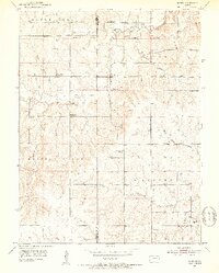
1952 Map of Dover
USGS Topo · Published 1953About this map
South Boundary Old Potawatomi Reservation cuts across the northern landscape of this Shawnee County survey, marking a significant historical line in the Kansas interior. The settlement of Dover serves as the central hub, situated near the confluence where Mission Creek winds through the terrain. The map captures a period of educational transition, evidenced by the numerous decommissioned rural schoolhouses such as School No 5 (Abandoned) and Highland Sch (Abandoned), which reflect shifting demographics in the early 1950s. To the south, the Wakarusa River and its Middle Branch define the drainage patterns, while local landmarks like the Girl Scout Camp and Dover Cem provide specific points of interest for genealogists and local historians tracing family roots in the Auburn and Maple Hill townships.
Find a feature on this map
20 named features on this map. Tap any name to fly to it.
Don’t see what you’re looking for? This feature index may not catch every label — zoom into the map to look around manually.
Map Details
Editions of this 1952 Dover Map
3 editions found
Other maps of this area

1885 · Eskridge
USGS Topo · 1:125,000

1889 · Burlingame
USGS Topo · 1:125,000

1889 · Wamego
USGS Topo · 1:125,000

1889 · Eskridge
USGS Topo · 1:125,000

1889 · Topeka
USGS Topo · 1:125,000

1894 · Eskridge
USGS Topo · 1:125,000

1894 · Burlingame
USGS Topo · 1:125,000

1894 · Topeka
USGS Topo · 1:125,000

1894 · Wamego
USGS Topo · 1:125,000

1947 · Lawrence
USGS Topo · 1:250,000