
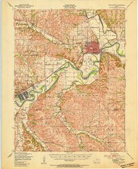
1947 Map of Manhattan
USGS Topo · Published 1954About this map
Kansas State College anchors the northeastern portion of this 1947 survey, where the Big Blue River meets the Kansas River. The map captures Manhattan in a post-war era of expansion, displaying a detailed street grid alongside vital transit corridors like the Chicago Rock Island and Pacific and Union Pacific railroads. To the west, the massive footprint of the Fort Riley Military Reservation dominates the landscape, featuring the sprawling infrastructure of Camp Funston and specialized zones like the Machine Gun Range and Pistol Ranges.
Find a feature on this map
74 named features on this map. Tap any name to fly to it.
Don’t see what you’re looking for? This feature index may not catch every label — zoom into the map to look around manually.
Map Details
Editions of this 1947 Manhattan Map
2 editions found
Other maps of this area

1885 · Eskridge
USGS Topo · 1:125,000

1886 · Junction City
USGS Topo · 1:125,000

1889 · Wamego
USGS Topo · 1:125,000

1889 · Junction City
USGS Topo · 1:125,000

1889 · Parkerville
USGS Topo · 1:125,000

1889 · Eskridge
USGS Topo · 1:125,000

1894 · Eskridge
USGS Topo · 1:125,000

1894 · Junction City
USGS Topo · 1:125,000

1894 · Parkerville
USGS Topo · 1:125,000

1894 · Wamego
USGS Topo · 1:125,000