1960s Maps of Allen Parish, Louisiana
Explore 12 historic maps of Allen Parish from the 1960s. These maps offer a rare glimpse into what life looked like during the 1960s — showing old roads, neighborhoods, homes, and landmarks that have changed or disappeared over time.
Whether you're researching your family's past, planning a metal detecting trip, or studying how Allen Parish's landscape evolved across the 1960s, these high-resolution maps are a powerful tool for exploring the history of this region.
- Focus on a specific era: All maps on this page are from the 1960s, giving you a focused view of this time period.
- See what’s changed: Compare century-old streets, trails, and buildings to today's modern landscape using overlays and satellite layers.
- Research with precision: Use these maps for genealogy, historical research, land use analysis, or educational projects.
- View, download, or print: Maps are fully viewable online in high resolution, and can be downloaded or printed for your own records.
Start exploring Allen Parish's history through authentic maps from the 1960s. This is your window into the past.
Allen Parish, LA maps
(12)- 1960 Map of Guy, 1961 Print
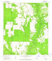
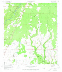 1960 Guy1961 Print · USGSThe rural landscapes of Allen Parish come to life in the early sixties, centered on the MISSOURI PACIFIC rail corridor. Genealogists can trace family footprints through numerous small burial sites like Reed Cem and Deshotel Cem, alongside the early oil infrastructure at Foley.4 unique versions available
 - 1960 Map of Pine Chapel, 1961 Print
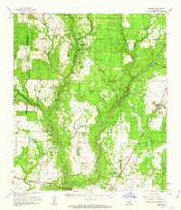
 1960 Pine Chapel1961 Print · USGSThe Louisiana piney woods of Allen Parish come to life in this mid-century survey of the Calcasieu River basin. Researchers can trace rural life and industry through landmarks like the Oakland Springs Cem, Pine Chapel, and the timber-watch Oberlin Lookout Tower.3 unique versions available
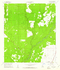
 - 1960 Map of Basile, 1961 Print
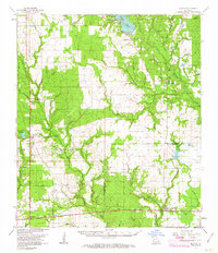
 1960 Basile1961 Print · USGSCoastal prairie life and petroleum exploration dominate this 1960s study of the area where Evangeline, Acadia, and Jefferson Davis parishes meet. Genealogists and historians can trace family roots through landmarks like St Ann Ch, China Cem, and the rural settlement of Panchoville.4 unique versions available
 - 1961 Map of Castor Creek, 1963 Print
 1961 Castor Creek1963 Print · USGSAllen and Evangeline Parishes are shown in the early sixties as timber and rail give way to oil and gas development. Trace family heritage at St Johns Chapel or McGee Mission, and locate vanished infrastructure along the Old Railroad Grade.2 unique versions available
 - 1961 Map of Mittie, 1963 Print
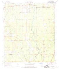
 1961 Mittie1963 Print · USGSAllen Parish life in the early sixties centers on the winding Whisky Chitto Creek and the small crossroads of Mittie. Genealogists and local historians can trace family roots at the Simmons Settlement or locate landmarks like Cherry Grove Ch and the Simmons Cem.3 unique versions available
 - 1961 Map of Oberlin, 1963 Print
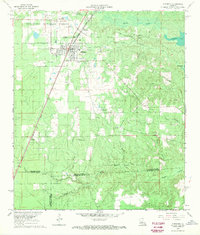
 1961 Oberlin1963 Print · USGSAllen Parish during the early sixties shows a landscape of timber and oil development along the MISSOURI PACIFIC. Genealogists can trace family roots at Simmons Settlement and historic sites like Pine Chapel Cem or St Johns Ch.2 unique versions available
 - 1961 Map of Reeves, 1963 Print
 1961 Reeves1963 Print · USGSSouthwest Louisiana in the early sixties reveals a landscape of growing petroleum production and established rail junctions. Genealogists and local historians can trace family locations near Longville, Reeves, and Fulton, or find old landmarks like Magnolia Ch and Frusha Cem.2 unique versions available
 - 1968 Map of Pawnee, 1969 Print
 1968 Pawnee1969 Print · USGSThe border of Rapides and Allen Parish in the late sixties reveals a landscape of timber tracts and river bottoms. Researchers can trace rural lineages through sites like Melder Cem, the settlement of Union Hill, and the tracks of the Missouri Pacific.2 unique versions available
 - 1968 Map of Glenmora, 1970 Print
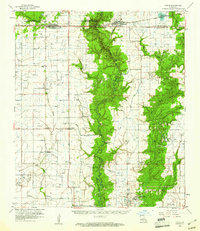
 1968 Glenmora1970 Print · USGSGlenmora and the Kisatchie National Forest are captured here in the late sixties as the local economy balanced timber, rail, and aviation. Researchers can locate family burial sites at Glenmora Cem or trace the Old Railroad Grade through McNary.2 unique versions available
 - 1968 Map of Oakdale, 1970 Print
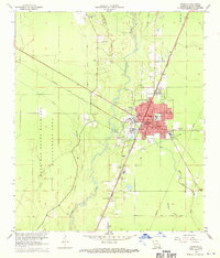
 1968 Oakdale1970 Print · USGSAllen Parish and Rapides Parish intersect during a period of industrial and aviation growth in the late sixties. Genealogists and local historians can trace family sites like Osburn Willis Cem, Bethany Ch, and the rural community of Union Hill.
 - 1968 Map of Oakdale, 1970 Print
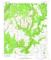
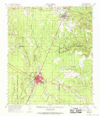
 1968 Oakdale1970 Print · USGSOakdale serves as a busy rail and aviation hub in the late sixties, where the timberlands meet industrial infrastructure. Researchers can trace family roots through several local landmarks like Oak Hill Cem, Mt Vernon Ch, and the Sacred Heart Cem.3 unique versions available
 - 1968 Map of Beaver, 1970 Print
 1968 Beaver1970 Print · USGSEvangeline and Allen Parishes are captured here in the late sixties, showing a landscape defined by timber, bayous, and rural homesteads. Trace local family history at the Beaver Cem and Pecan Grove Cem, or locate the site of the Beaver Lookout Tower.
End of results
Showing maps 1-12 of 12
Top cities of Allen Parish
- Oakdale historical maps
- Kinder historical maps
- Oberlin historical maps
- Elizabeth historical maps
- Reeves historical maps
Frequently asked questions
- What are the different types of historical maps available for Allen Parish?
- What is the oldest map of Allen Parish?
- Where can I purchase historical maps of Allen Parish for my home or office?
- Where can I download high-res historical maps of Allen Parish?
- Are there historical topographic maps available for Allen Parish?
- Is there historical aerial imagery available for Allen Parish?
- Where are historical maps of Allen Parish sourced from?