2000-2009 Maps of Allen Parish, Louisiana
Explore 3 historic maps of Allen Parish from 2000-2009. These maps offer a rare glimpse into what life looked like during the 2000s — showing old roads, neighborhoods, homes, and landmarks that have changed or disappeared over time.
Whether you're researching your family's past, planning a metal detecting trip, or studying how Allen Parish's landscape evolved across the 2000s, these high-resolution maps are a powerful tool for exploring the history of this region.
- Focus on a specific era: All maps on this page are from the 2000s, giving you a focused view of this time period.
- See what’s changed: Compare century-old streets, trails, and buildings to today's modern landscape using overlays and satellite layers.
- Research with precision: Use these maps for genealogy, historical research, land use analysis, or educational projects.
- View, download, or print: Maps are fully viewable online in high resolution, and can be downloaded or printed for your own records.
Start exploring Allen Parish's history through authentic maps from the 2000s. This is your window into the past.
Allen Parish, LA maps
(3)- 2003 Map of Glenmora, 2005 Print
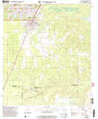 2003 Glenmora2005 Print · USGSThe crossroads of Rapides and Evangeline parishes come into focus at the turn of the twenty-first century. Genealogists can locate family landmarks like Rose Lawn Cem and Science Hill Cem, or trace rural aviation at Angrus Landing Field.
 - 2003 Map of Pawnee, 2005 Print
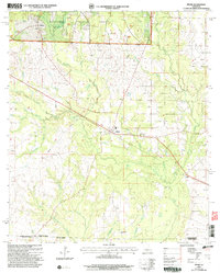
 2003 Pawnee2005 Print · USGSRapides and Allen Parishes are shown at the turn of the millennium as centers of forestry and quiet rural life. Researchers can trace family roots at the Osburn Willis Cem or locate community hubs like Union Hill, Davis Crossing Ch, and the remote Pawnee settlement.
 - 2003 Map of Pitkin, 2005 Print
 2003 Pitkin2005 Print · USGSThe northern edge of the Louisiana piney woods comes alive in this study of the Vernon Parish countryside. Researchers can trace the rural communities of Pitkin, Fullerton, and Dido alongside local landmarks like Crowder Cem and Mount Olive Ch.
End of results
Showing maps 1-3 of 3
Top cities of Allen Parish
- Oakdale historical maps
- Kinder historical maps
- Oberlin historical maps
- Elizabeth historical maps
- Reeves historical maps
Frequently asked questions
- What are the different types of historical maps available for Allen Parish?
- What is the oldest map of Allen Parish?
- Where can I purchase historical maps of Allen Parish for my home or office?
- Where can I download high-res historical maps of Allen Parish?
- Are there historical topographic maps available for Allen Parish?
- Is there historical aerial imagery available for Allen Parish?
- Where are historical maps of Allen Parish sourced from?