1980s Maps of Allen Parish, Louisiana
Explore 15 historic maps of Allen Parish from the 1980s. These maps offer a rare glimpse into what life looked like during the 1980s — showing old roads, neighborhoods, homes, and landmarks that have changed or disappeared over time.
Whether you're researching your family's past, planning a metal detecting trip, or studying how Allen Parish's landscape evolved across the 1980s, these high-resolution maps are a powerful tool for exploring the history of this region.
- Focus on a specific era: All maps on this page are from the 1980s, giving you a focused view of this time period.
- See what’s changed: Compare century-old streets, trails, and buildings to today's modern landscape using overlays and satellite layers.
- Research with precision: Use these maps for genealogy, historical research, land use analysis, or educational projects.
- View, download, or print: Maps are fully viewable online in high resolution, and can be downloaded or printed for your own records.
Start exploring Allen Parish's history through authentic maps from the 1980s. This is your window into the past.
Allen Parish, LA maps
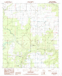
(15)- 1985 Map of Kinder
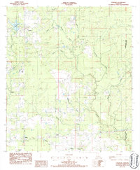
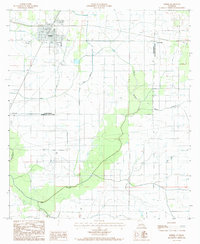 1985 Kinder1985 Print · USGSIn the mid-eighties, this Allen Parish landscape was a hub of irrigation and rail transport centered on Kinder. Genealogists and historians can trace family-named sites like Fontenot, the course of the Missouri Pacific railroad, and the winding Bayou Serpent.
 - 1985 Map of Basile
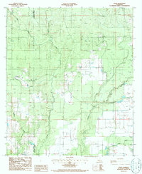
 1985 Basile1985 Print · USGSLouisiana's prairie and oil country come into focus in the mid-eighties as parish lines meet near Basile. Researchers can trace the industrial footprint of the Oil Field and find small settlements like Tepetate and Barwick along the bayous.2 unique versions available
 - 1985 Map of Indian Village
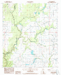
 1985 Indian Village1985 Print · USGSThe Calcasieu River valley and the parish boundary between Allen and Jefferson Davis are captured in the mid-1980s. Local history researchers can trace the small settlements of Indian Village and Edna or locate rural landmarks like Nevills Bluff and the local Sand Pit.
 - 1985 Map of Elton
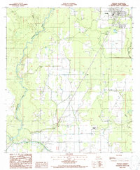
 1985 Elton1985 Print · USGSElton and the surrounding parish borders are captured here in the mid-1980s, showcasing the region's mix of prairie agriculture and energy production. Genealogists and historians can trace family locations near China, Barnsdall, and the Oil And Gas Field.
 - 1985 Map of Crowley, 1986 Print
 1985 Crowley1986 Print · USGSCoastal prairie and bayou country are captured in the mid-eighties as the rice-and-rail economy defined South Louisiana life. Genealogists and researchers can trace family lands and rural hubs from Crowley to Jennings, following the paths of the Southern Pacific Railroad and the winding Mermentau River.2 unique versions available
 - 1986 Map of DeRidder
 1986 DeRidder1986 Print · USGSThe Louisiana-Texas borderlands come to life in the mid-eighties, showcasing the timber country and rail corridors of the Sabine River valley. Researchers can trace the legacy of small communities and transit lines through Merryville, Holly Springs, and the Missouri Pacific railroad.2 unique versions available
 - 1986 Map of Ville Platte
 1986 Ville Platte1986 Print · USGSCentral Louisiana in the 1980s reveals a complex landscape of pine forests and bayou networks spanning seven distinct parishes. Researchers can trace historic rail lines like the Atchison Topeka and Santa Fe RR and locate settlements such as Simmons Settlement, Redland, and Elizabeth.2 unique versions available
 - 1986 Map of Longville
 1986 Longville1986 Print · USGSThe Beauregard Parish lowlands near the Allen Parish line are captured in the mid-1980s, revealing a landscape of rural communities and energy infrastructure. Researchers can trace the development of Longville, Fulton, and Ragley alongside the Oil Refinery and winding Barnes Creek.
 - 1986 Map of Bond
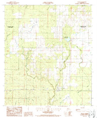
 1986 Bond1986 Print · USGSEvangeline and Allen Parishes are captured in the mid-1980s, showing a managed Louisiana landscape of forestry and water control. Researchers can trace the settlement at Bond, locate the local Cem, and follow drainage networks like Bayou Nezpique and the Well Pump Canal.
 - 1986 Map of Lake Charles
 1986 Lake Charles1986 Print · USGSThe Louisiana-Texas borderlands are captured here in the mid-1980s, showcasing the industrial growth of the Lake Charles region and its rail-linked satellite towns. Trace the evolution of coastal settlements and family landmarks from Sulphur to the Highland Cem.2 unique versions available
 - 1986 Map of Duralde, 1987 Print
 1986 Duralde1987 Print · USGSThe prairies along the Evangeline and Allen Parish line were deeply integrated with the bayous in the mid-1980s. Researchers can trace rural settlement patterns and local water works around Duralde, Valentine, and the winding Bayou Nezpique.
 - 1986 Map of Oberlin, 1987 Print
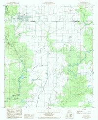
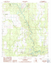
 1986 Oberlin1987 Print · USGSAllen Parish in the mid-1980s centered on the confluence of natural waterways and modern irrigation. Researchers can trace rural settlements like Le Jeune and Lyles, or locate the Coushatta Indian Reservation and the Lookout Tower.
 - 1986 Map of Soileau, 1987 Print
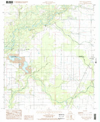
 1986 Soileau1987 Print · USGSAllen Parish in the mid-eighties shows a landscape of tribal lands and rural settlements defined by the winding Blue Bayou. Trace the borders of the Coushatta Indian Reservation and locate local landmarks like Soileau and the cemetery at Cem.
 - 1986 Map of Le Blanc, 1987 Print
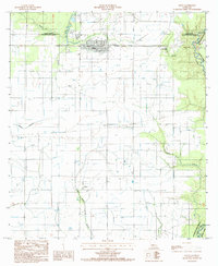
 1986 Le Blanc1987 Print · USGSAllen Parish in the mid-eighties shows a landscape shaped by the Whisky Chitto Creek and the Calcasieu River. Researchers can trace the Old Railroad Grade and locate local landmarks like Le Blanc and Carpenters Bridge.
 - 1986 Map of Reeves, 1987 Print
 1986 Reeves1987 Print · USGSLouisiana's western piney woods are captured here in the mid-1980s, centered on the communities of Reeves and Bel. Genealogists and local historians can trace the landscape's features from the Bel Lookout Tower to the banks of Clear Creek and Cane Brake Creek.
End of results
Showing maps 1-15 of 15
Top cities of Allen Parish
- Oakdale historical maps
- Kinder historical maps
- Oberlin historical maps
- Elizabeth historical maps
- Reeves historical maps
Frequently asked questions
- What are the different types of historical maps available for Allen Parish?
- What is the oldest map of Allen Parish?
- Where can I purchase historical maps of Allen Parish for my home or office?
- Where can I download high-res historical maps of Allen Parish?
- Are there historical topographic maps available for Allen Parish?
- Is there historical aerial imagery available for Allen Parish?
- Where are historical maps of Allen Parish sourced from?