1990s Maps of Cameron Parish, Louisiana
Explore 16 historic maps of Cameron Parish from the 1990s. These maps offer a rare glimpse into what life looked like during the 1990s — showing old roads, neighborhoods, homes, and landmarks that have changed or disappeared over time.
Whether you're researching your family's past, planning a metal detecting trip, or studying how Cameron Parish's landscape evolved across the 1990s, these high-resolution maps are a powerful tool for exploring the history of this region.
- Focus on a specific era: All maps on this page are from the 1990s, giving you a focused view of this time period.
- See what’s changed: Compare century-old streets, trails, and buildings to today's modern landscape using overlays and satellite layers.
- Research with precision: Use these maps for genealogy, historical research, land use analysis, or educational projects.
- View, download, or print: Maps are fully viewable online in high resolution, and can be downloaded or printed for your own records.
Start exploring Cameron Parish's history through authentic maps from the 1990s. This is your window into the past.
Cameron Parish, LA maps
(16)- 1993 Map of Texas Point
 1993 Texas Point1993 Print · USGSThe Texas and Louisiana coastline meets the Gulf in the early 1990s, centering on the vital maritime corridor of Sabine Pass. Researchers can trace harbor infrastructure and coastal conservation lands like Sabine Pass Battleground State Historical Park and the U S Coast Guard Station.
 - 1993 Map of Port Arthur South
 1993 Port Arthur South1993 Print · USGSJefferson County's industrial coastline and the Sabine Lake marshes are captured in the early nineties, revealing a landscape of heavy shipping and civic life. Trace the local geography from Lincoln High Sch to the expansive J D Murphree Wildlife Management Area.
 - 1993 Map of Sabine Pass
 1993 Sabine Pass1993 Print · USGSIn the early 1990s, the Texas-Louisiana border at Sabine Pass maintained a unique balance of industrial shipping and protected wetlands. Genealogists and researchers can locate the Pace Cem and McGaffey Cem or trace the early reach of Sea Rim State Park.
 - 1993 Map of West of Johnson Bayou
 1993 West of Johnson Bayou1993 Print · USGSThe Louisiana coast near the Texas border appears in the early nineties as a landscape of marsh and ridges. Genealogists and historians can trace the remote Johnson Bayou Landing and family-named landmarks like Garner Ridge and Salt Work Ridge.
 - 1993 Map of West of Greens Bayou
 1993 West of Greens Bayou1993 Print · USGSCoastal Texas and Louisiana are mapped here in the early nineties, showing the industrial waterways and marshlands where the state borders meet. Researchers can trace the dredged paths of the Intracoastal Waterway past Humble Island and into the Sabine National Wildlife Refuge.
 - 1994 Map of Lake Arthur, 1996 Print
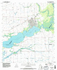 1994 Lake Arthur1996 Print · USGSCoastal Jefferson Davis Parish in the mid-nineties is defined by the expanse of Lake Arthur and its industrial water networks. Trace family roots in the town of Lake Arthur or explore the drainage systems around the Klondike Canal and the Narrows.
 - 1994 Map of Moss Lake, 1996 Print
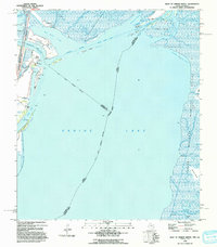
 1994 Moss Lake1996 Print · USGSCoastal Louisiana's industrial waterways dominate the landscape in the mid-1990s as the ship channels cut through the marshes. Researchers can trace family history at Dutch Cove Cem or explore the energy infrastructure of the Big Lake Oil Field.
 - 1996 Map of Orange, 1999 Print
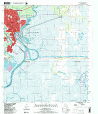 1996 Orange1999 Print · USGSNear the Texas-Louisiana border in the late nineties, the Sabine River supports a massive industrial and naval hub. Researchers can trace the development of Orange through its numerous schools like Solomon Johnson Sch and waterfront sites like Harbor Island.
 - 1998 Map of Cameron, 2000 Print
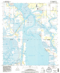
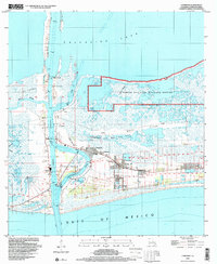 1998 Cameron2000 Print · USGSCoastal Louisiana near the close of the century reveals a landscape shaped by the energy industry and maritime commerce at the Gulf's edge. Researchers can trace family history at Wakefield Mem Cem or explore industrial roots through the Cameron Oil and Gas Field.
 - 1998 Map of Black Lake, 2000 Print
 1998 Black Lake2000 Print · USGSThe marshlands of Calcasieu Parish meet the coastal waters of Cameron Parish in this late-twentieth-century study of Louisiana's energy landscape. Researchers can locate family landmarks like Moss Cem and Landry Cem amid the massive West Hackberry Oil Field.
 - 1998 Map of Holly Beach, 2000 Print
 1998 Holly Beach2000 Print · USGSThe Louisiana coast at the turn of the millennium reveals a delicate intersection of energy extraction and wildlife conservation. Trace the intricate shoreline around Holly Beach and the vast marshes of the Sabine National Wildlife Refuge.
 - 1998 Map of Lake Charles SW, 2001 Print
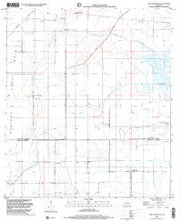
 1998 Lake Charles SW2001 Print · USGSCoastal Louisiana at the close of the twentieth century shows a landscape defined by industry and water management across the Calcasieu-Cameron parish line. Trace local history at the Hebert Cem, Grand Lake Sch, and the Oil Field near the Intracoastal Waterway.
 - 1998 Map of Lake Charles SE, 2001 Print
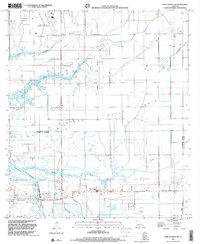
 1998 Lake Charles SE2001 Print · USGSCalcasieu and Cameron Parishes are shown in the late 1990s, revealing a landscape of coastal prairie and managed waterways. Researchers can locate the community of Holmwood and local landmarks like St Joseph Ch and the Sweet Lake Pumping Station.
 - 1998 Map of Catfish Lake, 2003 Print
 1998 Catfish Lake2003 Print · USGSCoastal Louisiana marshes near Grand Lake reveal a landscape of cheniers and bayous at the end of the century. Trace the isolated reaches of Little Pecan Island or the industrial footprints of the Gas Field and Dr Miller Canal.
 - 1998 Map of Grand Bayou, 2003 Print
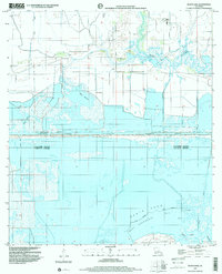
 1998 Grand Bayou2003 Print · USGSCoastal Cameron Parish in the late nineties is defined by its sprawling wetlands and ridge-top settlements along the Gulf. Researchers can trace local lineage through sites like Duhon Cem, Ebenezer Ch Cem, and the Cameron Vocational Techical Sch.
 - 1998 Map of Peveto Beach, 2003 Print
 1998 Peveto Beach2003 Print · USGSCoastal Louisiana in the late nineties reveals a landscape where marsh conservation meets heavy industry along the Gulf. Researchers can trace the development of the Cameron Meadows Oil and Gas Field and locate the small coastal community at Constance Beach.
End of results
Showing maps 1-16 of 16
Top cities of Cameron Parish
Frequently asked questions
- What are the different types of historical maps available for Cameron Parish?
- What is the oldest map of Cameron Parish?
- Where can I purchase historical maps of Cameron Parish for my home or office?
- Where can I download high-res historical maps of Cameron Parish?
- Are there historical topographic maps available for Cameron Parish?
- Is there historical aerial imagery available for Cameron Parish?
- Where are historical maps of Cameron Parish sourced from?