1970s Maps of Cameron Parish, Louisiana
Explore 16 historic maps of Cameron Parish from the 1970s. These maps offer a rare glimpse into what life looked like during the 1970s — showing old roads, neighborhoods, homes, and landmarks that have changed or disappeared over time.
Whether you're researching your family's past, planning a metal detecting trip, or studying how Cameron Parish's landscape evolved across the 1970s, these high-resolution maps are a powerful tool for exploring the history of this region.
- Focus on a specific era: All maps on this page are from the 1970s, giving you a focused view of this time period.
- See what’s changed: Compare century-old streets, trails, and buildings to today's modern landscape using overlays and satellite layers.
- Research with precision: Use these maps for genealogy, historical research, land use analysis, or educational projects.
- View, download, or print: Maps are fully viewable online in high resolution, and can be downloaded or printed for your own records.
Start exploring Cameron Parish's history through authentic maps from the 1970s. This is your window into the past.
Cameron Parish, LA maps
(16)- 1973 Map of Port Arthur, 1974 Print
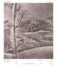
 1973 Port Arthur1974 Print · USGSThe Texas-Louisiana borderlands in the early seventies reveal an intricate landscape of coastal marshes and heavy industry. Trace the growth of Port Arthur, the extent of the oil and gas fields, and old ridge settlements like Pecan Island.
 - 1975 Map of Cameron, 1976 Print
 1975 Cameron1976 Print · USGSCoastal Louisiana in the mid-seventies is captured in this detailed aerial perspective of the marshland and maritime interface. Researchers can trace the mid-century layout of Cameron and the shipping infrastructure along Calcasieu Pass and Calcasieu Lake.
 - 1975 Map of Peveto Beach, 1976 Print
 1975 Peveto Beach1976 Print · USGSThe Louisiana coastline at Peveto Beach is captured in the mid-1970s through this detailed aerial orthophoto. Researchers can trace the winding natural waterways of Old North Bayou and Old East Bayou along the Gulf of Mexico.
 - 1975 Map of Grand Bayou, 1976 Print
 1975 Grand Bayou1976 Print · USGSCoastal Louisiana marshes and the chenier plain are seen in high detail during the mid-1970s. Researchers can trace the winding path of Grand Bayou and examine the natural shoreline along the Gulf of Mexico and Calcasieu Lake.
 - 1975 Map of Holly Beach, 1976 Print
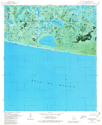
 1975 Holly Beach1976 Print · USGSCoastal Cameron Parish is captured in the mid-seventies, showing the fragile intersection of marshland and the gulf. Researchers can trace the layout of Holly Beach and the expansive shoreline of Calcasieu Lake and Mud Lake.
 - 1975 Map of Johnsons Bayou, 1976 Print
 1975 Johnsons Bayou1976 Print · USGSSouthwest Louisiana coastal life is captured in the mid-seventies, showing the ridge-top settlement of Johnsons Bayou along the Gulf. Researchers can trace the winding path of Old East Bayou and the early layout of roads and canals near the Gulf of Mexico.
 - 1979 Map of Rollover Lake, 1980 Print
 1979 Rollover Lake1980 Print · USGSThe Louisiana coast in the late seventies is captured here at the boundary of Vermilion and Cameron Parishes. Trace the managed wetlands of the Rockefeller State Wildlife Refuge and find landmarks like Refuge Camp and Rollover Lake.2 unique versions available
 - 1979 Map of Cow Island, 1980 Print
 1979 Cow Island1980 Print · USGSCoastal Louisiana marshes meet the Gulf of Mexico in this late-1970s orthophotomap of Cameron Parish. Genealogists and researchers can trace the ridge-line community around St Eugene Ch, Circle Cem, and the Nunez Landing Strip.
 - 1979 Map of Big Constance Lake, 1980 Print
 1979 Big Constance Lake1980 Print · USGSThe Cameron Parish coastline is captured during the late seventies, showing where the marshlands meet the sea. Naturalists and coastal researchers can trace the intricate waterways of Rockefeller State Wildlife Refuge and the expanses of Big Constance Lake.
 - 1979 Map of Lake Le Bleu, 1980 Print
 1979 Lake Le Bleu1980 Print · USGSThe coastal marshes of Vermilion and Cameron Parishes are shown during the late 1970s as industrial energy production reshaped the wetlands. Researchers can trace the West White Lake Oil and Gas Field and traditional water routes like the Noah Pirogue Trail.
 - 1979 Map of Latanier Bayou, 1980 Print
 1979 Latanier Bayou1980 Print · USGSCoastal Vermilion Parish in the late 1970s shows a landscape transformed by drainage canals and the oil industry. Researchers can trace local landmarks like Florence Landing, the Gueydan Cem, and the massive Intracoastal Waterway through the marsh.
 - 1979 Map of Collicon Lake, 1980 Print
 1979 Collicon Lake1980 Print · USGSCameron Parish's coastal wetlands are captured in the late seventies as industrial development reshaped the marsh. Researchers can trace the layout of the Pecan Lake Gas Field and landmarks like Cheniere du Fond or Petit Lac L' Huit.
 - 1979 Map of Mallard Bay, 1980 Print
 1979 Mallard Bay1980 Print · USGSCameron Parish's coastal wetlands are captured here in the late seventies, showing the vital energy infrastructure and waterways of the Louisiana coast. Researchers can trace the Intracoastal Waterway, the isolated settlement of Mallard, and named features like Oak Island and Maple Marsh.
 - 1979 Map of Floating Turf Bayou, 1980 Print
 1979 Floating Turf Bayou1980 Print · USGSCoastal Vermilion Parish marshlands come to life in this late-seventies orthophotomap of the Gulf wetlands. Researchers can trace the sprawling boundaries of the Rockefeller State Wildlife Refuge and Game Preserve and locate sites like the Lookout Tower and Oil Wells.
 - 1979 Map of Deep Lake, 1980 Print
 1979 Deep Lake1980 Print · USGSCoastal Louisiana marshland meets industrial infrastructure in the late seventies, documented through a unique aerial orthophotomap. Genealogists and historians can trace family-named locations like Doland and Tiger Island or locate remote outposts like Refuge Camp.2 unique versions available
 - 1979 Map of Hog Bayou, 1980 Print
 1979 Hog Bayou1980 Print · USGSCoastal Louisiana at the end of the seventies shows a landscape where industrial energy extraction meets critical wildlife conservation. You can trace the proximity of the Club Gas Field to the Rockefeller State Wildlife Refuge and Game Preserve and locate numerous wells along Hog Bayou.
End of results
Showing maps 1-16 of 16
Top cities of Cameron Parish
Frequently asked questions
- What are the different types of historical maps available for Cameron Parish?
- What is the oldest map of Cameron Parish?
- Where can I purchase historical maps of Cameron Parish for my home or office?
- Where can I download high-res historical maps of Cameron Parish?
- Are there historical topographic maps available for Cameron Parish?
- Is there historical aerial imagery available for Cameron Parish?
- Where are historical maps of Cameron Parish sourced from?