Old Maps of Cameron Parish, Louisiana for Academic Research
Study the evolution of Cameron Parish with 406 high-resolution historic maps. Whether you're teaching, researching, or modeling changes in land use, these maps provide essential visual documentation of urban, environmental, and geographic change.
- Analyze long-term change: Track patterns in development, transportation, and natural features.
- Ideal for environmental or urban studies: Support academic projects with primary historical map data.
- Use in the classroom or lab: Educators and researchers rely on these maps to bring historical context to life.
These maps are a powerful tool for teaching, research, and visualizing how Cameron Parish has changed over the decades.
Cameron Parish, LA maps
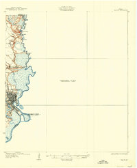
(406)- 1932 Map of Sabine Pass NE
 1932 Sabine Pass NE1932 Print · USGSThe maritime border between Louisiana and Texas is captured here in the early 1930s as a hub of coastal engineering and rail transport. Researchers can trace the industrial shoreline along the Southern Pacific railroad and the historical East Bdy Old Military Reservation.
 - 1932 Map of Constance Bayou NE
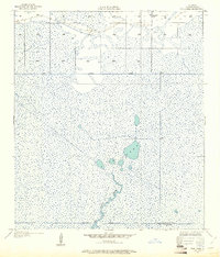
 1932 Constance Bayou NE1932 Print · USGSCoastal Louisiana marshes in the early thirties reveal a landscape of deep bayous and isolated ridges. Researchers can trace the sinuous path of Floating Turf Bayou or locate the historic elevation of Pecan Island and Long Island.2 unique versions available
 - 1932 Map of Moss Lake
 1932 Moss Lake1932 Print · USGSCoastal Calcasieu Parish comes to life in the early 1930s as the Intracoastal Waterway begins to reshape the landscape. Researchers can trace family roots at Hackberry or locate the historic Dutch Cove Cemetery and Ellender Ferry crossings.
 - 1932 Map of Orange
 1932 Orange1932 Print · USGSSoutheastern Texas at the dawn of the 1930s is defined by the bustling riverfront of Orange and the intricate bends of the Sabine River. Researchers can trace the early street plan of the city, the Southern Pacific rail lines, and river landmarks like Morgan Bluff.2 unique versions available
 - 1932 Map of Constance Bayou SW
 1932 Constance Bayou SW1932 Print · USGSThe Louisiana coastline in Cameron Parish is captured here during the early 1930s, showing a landscape shaped entirely by water and marsh. Researchers can trace the natural drainage of Big Constance Lake and Constance Bayou into the Gulf of Mexico.
 - 1932 Map of Lake Charles SW
 1932 Lake Charles SW1932 Print · USGSIn the early 1930s, this portion of southern Louisiana was a landscape defined by the meeting of coastal wetlands and rural prairie. Genealogists and local historians can locate early educational and religious centers like Grand Lake Sch and Prairieland Community Ch near the banks of Black Bayou.
 - 1932 Map of Port Arthur NE
 1932 Port Arthur NE1932 Print · USGSThe Louisiana coast near the Texas border comes alive in this early Depression-era survey of the coastal marshes. Local historians can trace the foundations of Rosenthal-Brown Camp and the reach of the Willow Bayou Canal along the edges of Sabine Lake.
 - 1932 Map of Lake Charles SE
 1932 Lake Charles SE1932 Print · USGSCalcasieu and Cameron Parishes are captured here in the early thirties, showing a rural landscape shaped by rail and irrigation. Genealogists can locate the Sweet Lake Sch and the settlement of Holmwood along the Southern Pacific line.
 - 1932 Map of Constance Bayou SE
 1932 Constance Bayou SE1932 Print · USGSThe Louisiana coastline in the early thirties reveals a wild landscape of marsh and tide at the junction of Cameron and Vermilion Parishes. Researchers can trace the original paths of Muskrat Bayou and Rollover Bayou as they feed into Flat Lake and Rollover Lake.
 - 1932 Map of Constance Bayou NW
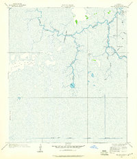
 1932 Constance Bayou NW1932 Print · USGSCameron Parish was a landscape of tide-driven marshes and isolated island settlements in the early 1930s. Genealogists and historians can locate remote outposts like Josephine, the North Island Sch, and landmarks like Money Island and Deep Lake.
 - 1934 Map of Catfish Lake, 1955 Print
 1934 Catfish Lake1955 Print · USGSCoastal Louisiana marshes near the Mermentau River were a web of waterborne transit in the 1930s. Genealogists and historians can trace old outposts like Catfish, the winding Pirogue Trail, and early infrastructure like the Miller Canal.2 unique versions available
 - 1934 Map of Johnsons Bayou, 1955 Print
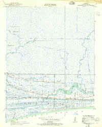 1934 Johnsons Bayou1955 Print · USGSCameron Parish's coastal ridge settlements are captured here in the mid-1930s, showing the intersection of local community life and the marshy Gulf landscape. Researchers can locate the Johnsons Bayou School, the Pevoto Cemetery, and the local post office.3 unique versions available
 - 1934 Map of Cameron, 1955 Print
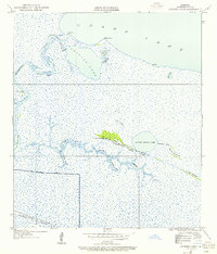
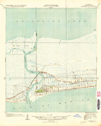
 1934 Cameron1955 Print · USGSCoastal Louisiana at the edge of the gulf is mapped here during the mid-1930s, showing a landscape of marsh ridges and vital waterways. Researchers can trace the layout of Cameron and locate local landmarks like the Rose Sch or the winding Calcasieu Pass.3 unique versions available
 - 1934 Map of Holly Beach, 1955 Print
 1934 Holly Beach1955 Print · USGSThe Cameron Parish coastline during the 1930s reveals a wilderness of brackish lakes and coastal marshes before modern erosion took its toll. Trace early settlements at Holly Beach and follow the intricate waterways from Mud Lake to Oyster Lake.2 unique versions available
 - 1934 Map of Lake Misere, 1955 Print
 1934 Lake Misere1955 Print · USGSCameron Parish wetlands were a complex network of marshes and new industrial channels in the mid-1930s. Local researchers can trace the early path of the Intracoastal Waterway near the settlements of Cady and Misere.2 unique versions available
 - 1934 Map of Peveto Beach, 1958 Print
 1934 Peveto Beach1958 Print · USGSThe Louisiana coast in the mid-1930s reveals a sparse network of marshes and early beachfront settlements. Trace the original lot layouts at Peveto Beach and Beach Camp or follow the winding path of Old North Bayou through the wetlands.
 - 1934 Map of Sweet Lake, 1959 Print
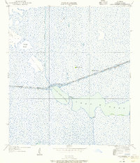
 1934 Sweet Lake1959 Print · USGSCoastal Louisiana marshes are documented here in the mid-1930s as drainage canals began to reshape the wetlands of Cameron Parish. Genealogists and local historians can locate the early footprints of Willow and Sweet Lake or trace the winding course of Mangrove Bayou.
 - 1934 Map of Greens Bayou, 1960 Print
 1934 Greens Bayou1960 Print · USGSCameron Parish in the mid-1930s is revealed here as an intricate world of bayous and marsh outposts. Researchers can trace the early drainage network and locate seasonal settlements like Lone Pine, Grays Camp, and Gate Camp along the banks of Black Bayou.2 unique versions available
 - 1934 Map of Browns Lake, 1960 Print
 1934 Browns Lake1960 Print · USGSCoastal Cameron Parish at the height of the 1930s reveals a world of salt marshes and vital waterways. Genealogists and local historians can trace the early layout of Hackberry Sch and the natural elevations of Back Ridge near Browns Lake.
 - 1934 Map of Grand Bayou, 1961 Print
 1934 Grand Bayou1961 Print · USGSCameron Parish in the mid-1930s shows a landscape of coastal ridges and intricate bayous just before modern development altered the wetlands. Genealogists and historians can trace family locations along the cheniers, passing through Chartelyou and community hubs like Creole Sch and St Theresa Ch.
 - 1934 Map of Boudreaux Lake, 1961 Print
 1934 Boudreaux Lake1961 Print · USGSThe marshlands of Cameron Parish are captured here in the mid-thirties as the modern industrial era began to reshape the coast. Researchers can trace the path of the Intracoastal Waterway and find local landmarks like the Coastal Hunting Club and Savanne Neuville Island.
 - 1934 Map of Five Lakes, 1961 Print
 1934 Five Lakes1961 Print · USGSCoastal Cameron Parish in the mid-1930s reveals a water-bound world of marsh camps and early drainage canals. Trace the locations of Stacks Hill Camp and the Orange-Cameron Co Club House amidst the winding Old North Bayou and Five Lakes.2 unique versions available
 - 1934 Map of Latania Lake, 1961 Print
 1934 Latania Lake1961 Print · USGSThe coastal marshlands of Cameron Parish in the mid-1930s reveal a landscape of intricate bayous and expansive lakes. Researchers can trace the early path of the Intracoastal Waterway and locate traditional routes like the Pirogue Trail near Latania Hill.
 - 1935 Map of Peveto Beach
 1935 Peveto Beach1935 Print · USGSCoastal Cameron Parish at the height of the 1930s reveals a string of isolated shoreline settlements and marshy bayous. Genealogists and historians can trace early residents and landmarks near Peveto Beach, Eli Ridge, and the Starks Canal landing.
 - 1935 Map of Cameron
 1935 Cameron1935 Print · USGSCoastal Louisiana at the edge of the Gulf comes to life in the mid-1930s as the community of Cameron manages its vital waterways. Genealogists and local historians can trace early land lines and find landmarks like the Rose Sch and Calcasieu Light.
Showing maps 1-25 of 406
Top cities of Cameron Parish
Frequently asked questions
- What are the different types of historical maps available for Cameron Parish?
- What is the oldest map of Cameron Parish?
- Where can I purchase historical maps of Cameron Parish for my home or office?
- Where can I download high-res historical maps of Cameron Parish?
- Are there historical topographic maps available for Cameron Parish?
- Is there historical aerial imagery available for Cameron Parish?
- Where are historical maps of Cameron Parish sourced from?