1940s Maps of Catahoula Parish, Louisiana
Explore 8 historic maps of Catahoula Parish from the 1940s. These maps offer a rare glimpse into what life looked like during the 1940s — showing old roads, neighborhoods, homes, and landmarks that have changed or disappeared over time.
Whether you're researching your family's past, planning a metal detecting trip, or studying how Catahoula Parish's landscape evolved across the 1940s, these high-resolution maps are a powerful tool for exploring the history of this region.
- Focus on a specific era: All maps on this page are from the 1940s, giving you a focused view of this time period.
- See what’s changed: Compare century-old streets, trails, and buildings to today's modern landscape using overlays and satellite layers.
- Research with precision: Use these maps for genealogy, historical research, land use analysis, or educational projects.
- View, download, or print: Maps are fully viewable online in high resolution, and can be downloaded or printed for your own records.
Start exploring Catahoula Parish's history through authentic maps from the 1940s. This is your window into the past.
Catahoula Parish, LA maps
(8)- 1940 Map of Marksville, 1943 Print
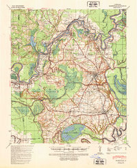 1940 Marksville1943 Print · USGSAvoyelles Parish life in the early 1940s is centered on the river-and-rail economy of the Red River valley. Genealogists and historians can trace family locations through numerous named churches and schools, such as Hickory Hill Sch, Vick, and the St Paul Ch & Cem.2 unique versions available
 - 1941 Map of Manifest, 1943 Print
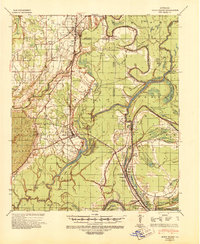
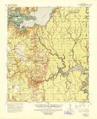
 1941 Manifest1943 Print · USGSCatahoula Parish in the early 1940s is defined by its strategic river junctions and a sprawling network of bayous. Researchers can trace the riverfront development of Jonesville and Trinity or locate rural landmarks like Bethel Ch and the Indian Mound.
 - 1941 Map of Sicily Island, 1943 Print
 1941 Sicily Island1943 Print · USGSLouisiana's delta country comes alive in the 1940s as a complex network of bayous, landings, and rail lines. Genealogists and historians can trace the foundations of local life through rural landmarks like Sunnyside Sch & Ch, several Indian Mounds, and the Missouri Pacific rail corridor.2 unique versions available
 - 1941 Map of Jena, 1943 Print
 1941 Jena1943 Print · USGSLa Salle Parish at the start of the 1940s shows a landscape of timber towns and lowland lakes. Trace family roots at Fellowship Ch, see the industrial lines of the Louisiana & Arkansas RR, or locate old sites like Rhinehart and Nebo.
 - 1941 Map of Voorhies, 1943 Print
 1941 Voorhies1943 Print · USGSAvoyelles Parish is captured here in the early 1940s, showcasing a river-bound landscape shaped by the Red River and its many oxbows. Genealogists can trace family roots through numerous landmarks like St James Ch & Cem, Voorhies School, and Moreauville.2 unique versions available
 - 1941 Map of Buckeye, 1944 Print
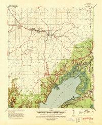
 1941 Buckeye1944 Print · USGSCentral Louisiana’s wetland and prairie interface is captured here in the early 1940s, showing the intricate water systems of the Rapides and La Salle parish lines. Genealogists can locate family landmarks like Barron Chapel, Guillory School, and the settlement of Holloway.2 unique versions available
 - 1941 Map of Tooleys, 1946 Print
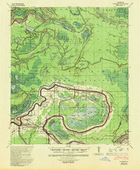
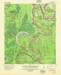 1941 Tooleys1946 Print · USGSLouisiana's river country comes to life in the 1940s as the confluence of the Black and Red Rivers shapes the delta parishes. Genealogists and historians can locate numerous landings like McDonald Ldg, local schools including Boggy Bayou Sch, and the Indian Mounds.2 unique versions available
 - 1941 Map of Harrisonburg, 1946 Print
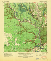 1941 Harrisonburg1946 Print · USGSThe Ouachita River valley in the early 1940s reveals a landscape of riverine commerce and upland settlements. Genealogists and researchers can locate historic community hubs like Harrisonburg, Siloam Ch, and the site of Fort Beauregard.
End of results
Showing maps 1-8 of 8
Top cities of Catahoula Parish
Frequently asked questions
- What are the different types of historical maps available for Catahoula Parish?
- What is the oldest map of Catahoula Parish?
- Where can I purchase historical maps of Catahoula Parish for my home or office?
- Where can I download high-res historical maps of Catahoula Parish?
- Are there historical topographic maps available for Catahoula Parish?
- Is there historical aerial imagery available for Catahoula Parish?
- Where are historical maps of Catahoula Parish sourced from?