1980s Maps of Saint Bernard Parish, Louisiana
Explore 7 historic maps of Saint Bernard Parish from the 1980s. These maps offer a rare glimpse into what life looked like during the 1980s — showing old roads, neighborhoods, homes, and landmarks that have changed or disappeared over time.
Whether you're researching your family's past, planning a metal detecting trip, or studying how Saint Bernard Parish's landscape evolved across the 1980s, these high-resolution maps are a powerful tool for exploring the history of this region.
- Focus on a specific era: All maps on this page are from the 1980s, giving you a focused view of this time period.
- See what’s changed: Compare century-old streets, trails, and buildings to today's modern landscape using overlays and satellite layers.
- Research with precision: Use these maps for genealogy, historical research, land use analysis, or educational projects.
- View, download, or print: Maps are fully viewable online in high resolution, and can be downloaded or printed for your own records.
Start exploring Saint Bernard Parish's history through authentic maps from the 1980s. This is your window into the past.
Saint Bernard Parish, LA maps
(7)- 1982 Map of Biloxi
 1982 Biloxi1982 Print · USGSThe Mississippi and Alabama coastlines are captured in the early eighties as industrial hubs and wildlife refuges shaped the shoreline. Trace maritime and military history through Fort Morgan, Keesler Air Force Base, and the barrier islands of Gulf Islands National Seashore.2 unique versions available
 - 1982 Map of North Islands
 1982 North Islands1982 Print · USGSThe Louisiana coast in the early eighties was a landscape of shifting barrier sands and tidal flats. Researchers can trace the fragile shoreline of the Chandeleur Islands and remote outposts like Freemason Island and Palos Island.
 - 1982 Map of Gulfport, 1983 Print
 1982 Gulfport1983 Print · USGSThe Gulf Coast between Louisiana and Mississippi appears in the early eighties as a landscape of marshland and maritime industry. Researchers can trace the path of the Louisville and Nashville RR through towns like Waveland and De Lisle, or locate the sprawling National Space Technology Laboratories.2 unique versions available
 - 1982 Map of Chandeleur Light, 1983 Print
 1982 Chandeleur Light1983 Print · USGSThe outer barrier islands of Louisiana are captured in the early 1980s, showcasing a fragile coastal landscape. Maritime researchers can locate Chandeleur Light and trace the wilderness boundaries of the Breton National Wilderness and Wildlife Refuge.
 - 1983 Map of New Orleans
 1983 New Orleans1983 Print · USGSSoutheast Louisiana in the early eighties reveals a landscape where the urban density of New Orleans meets the vast wetlands of the Salvador State Wildlife Management Area. Genealogists and historians can trace the traditional bayou settlements of Houma and Thibodaux alongside major rail lines like the Southern Pacific.2 unique versions available
 - 1983 Map of Black Bay
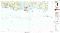
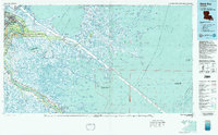 1983 Black Bay1983 Print · USGSCoastal St. Bernard Parish is shown in the early eighties as the Mississippi Delta's fishing villages and industrial infrastructure meet the expanding Gulf sounds. Genealogists and historians can trace family-named sites from Chalmette to Delacroix, including the Southern Railway System and St Bernard State Park.2 unique versions available
 - 1984 Map of Mobile
 1984 Mobile1984 Print · USGSThe Gulf Coast at the height of the mid-eighties shows a landscape of rapid industrial growth and military significance. Researchers can trace the sprawling rail lines of the Illinois Central Gulf RR, locate the NASA Test Facility, or study the barrier island chain from Cat Island to Petit Bois Island.3 unique versions available
End of results
Showing maps 1-7 of 7
Top cities of Saint Bernard Parish
Frequently asked questions
- What are the different types of historical maps available for Saint Bernard Parish?
- What is the oldest map of Saint Bernard Parish?
- Where can I purchase historical maps of Saint Bernard Parish for my home or office?
- Where can I download high-res historical maps of Saint Bernard Parish?
- Are there historical topographic maps available for Saint Bernard Parish?
- Is there historical aerial imagery available for Saint Bernard Parish?
- Where are historical maps of Saint Bernard Parish sourced from?