1990s Maps of Saint Bernard Parish, Louisiana
Explore 32 historic maps of Saint Bernard Parish from the 1990s. These maps offer a rare glimpse into what life looked like during the 1990s — showing old roads, neighborhoods, homes, and landmarks that have changed or disappeared over time.
Whether you're researching your family's past, planning a metal detecting trip, or studying how Saint Bernard Parish's landscape evolved across the 1990s, these high-resolution maps are a powerful tool for exploring the history of this region.
- Focus on a specific era: All maps on this page are from the 1990s, giving you a focused view of this time period.
- See what’s changed: Compare century-old streets, trails, and buildings to today's modern landscape using overlays and satellite layers.
- Research with precision: Use these maps for genealogy, historical research, land use analysis, or educational projects.
- View, download, or print: Maps are fully viewable online in high resolution, and can be downloaded or printed for your own records.
Start exploring Saint Bernard Parish's history through authentic maps from the 1990s. This is your window into the past.
Saint Bernard Parish, LA maps
(32)- 1992 Map of New Orleans East
 1992 New Orleans East1992 Print · USGSGreater New Orleans at the start of the nineties reveals a complex urban landscape shaped by the Mississippi River and industrial waterways. Trace neighborhood history through family-named landmarks like McDonoghville and historic sites like Metairie Cemetery or the Vieux Carre.
 - 1993 Map of English Lookout, 1995 Print
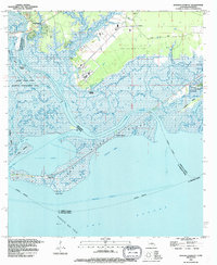 1993 English Lookout1995 Print · USGSThe coastal marshlands of the Mississippi-Louisiana border come alive in the 1990s as the river meets the gulf. Local historians can trace old waterfront sites at Jackson Landing and English Lookout or explore the development of the Ansley Gas Field.2 unique versions available
 - 1993 Map of Rigolets, 1995 Print
 1993 Rigolets1995 Print · USGSThe Louisiana coast near the Pearl River mouth comes to life in the early 1990s, where the deep-water passes of The Rigolets meet the marsh. Historians can trace the grounds of Fort Pike, locate the McKean Cem, and explore the maze of the Pearl River State Wildlife Management Area.
 - 1993 Map of Lena Lagoon, 1995 Print
 1993 Lena Lagoon1995 Print · USGSCoastal St. Bernard Parish in the early nineties is a labyrinth of tidal marsh and industrial shipping channels. Trace the impact of the Mississippi River-Gulf Outlet Canal on traditional waterways like Bayou La Loutre and Lagoon Giraud.
 - 1994 Map of False Mouth Bayou
 1994 False Mouth Bayou1994 Print · USGSThe St. Bernard Parish coast in the early nineties reveals a landscape of tidal marsh and energy extraction. Researchers can trace the wetlands around Lakes of Bayou Marron and the industrial footprint of the Rigolets Gas Field.
 - 1994 Map of Three Mile Bay
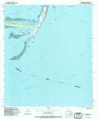
 1994 Three Mile Bay1994 Print · USGSCoastal St. Bernard Parish is seen here in the mid-1990s, revealing a complex landscape of tidal marsh and open water. Map collectors and researchers can trace the intricate shoreline of Three Mile Bay, locating named landmarks like Negro Point and Shell Island.
 - 1994 Map of Cat Island
 1994 Cat Island1994 Print · USGSThe barrier islands of the Mississippi Sound are captured in the mid-1990s, showing the complex shorelines of Cat Island and its surrounding channels. Researchers can trace coastal features like Smugglers Cove, Good Scotch Point, and the Great Sand Hill.
 - 1994 Map of Oak Mound Bayou
 1994 Oak Mound Bayou1994 Print · USGSCoastal St. Bernard Parish in the early nineties is a labyrinth of marshes and tidal passes where land and water merge. Researchers can trace the winding routes of Oak Mound Bayou and Live Oak Bayou or locate landmarks like Anderson Point.
 - 1994 Map of Mitchell Island
 1994 Mitchell Island1994 Print · USGSCoastal St. Bernard Parish reveals its intricate network of marshlands and tidal passes in the early 1990s. Researchers can trace the shifting shorelines of Mitchell Island and locate navigational landmarks like the Mitchell Key Light in Chandeleur Sound.
 - 1994 Map of Isle Au Pitre
 1994 Isle Au Pitre1994 Print · USGSThe coastal waters between Louisiana and Mississippi come into focus in the mid-1990s as the state line crosses through shifting shoals and sounds. Nautical researchers can trace the Intracoastal Waterway, locate the lighthouse on Cat Island, and explore the marshy reaches of Isle au Pitre.
 - 1994 Map of Malheureux Point
 1994 Malheureux Point1994 Print · USGSCoastal St. Bernard Parish was a labyrinth of tidal marshes and winding bayous in the mid-nineties. Researchers can trace the shifting shoreline of Malheureux Point or navigate the waterways of Whiskey Bayou and Kennedys Lagoon.
 - 1994 Map of Saint Joe Pass, 1995 Print
 1994 Saint Joe Pass1995 Print · USGSCoastal Hancock County and the watery border with Louisiana appear here in the mid-1990s as a maze of marsh and bayous. You can trace family roots at the Bayou Caddy Cem or explore the remote reaches of Half Moon Island and Ansley.2 unique versions available
 - 1994 Map of Pointe Aux Marchettes, 1995 Print
 1994 Pointe Aux Marchettes1995 Print · USGSCoastal St. Bernard Parish in the mid-nineties is a world of salt marsh and tidal lagoons where land and water merge. Local historians can trace the remote settlement at Saint Malo or explore the waterways of the Bayou Biloxy Gas Field and Magnolia Mound.
 - 1994 Map of Lake Eloi, 1995 Print
 1994 Lake Eloi1995 Print · USGSThe marshlands of St. Bernard Parish are shown in the early 1990s as a complex of tidal lagoons and active energy infrastructure. Researchers can trace the layout of the Half Moon Lake Oil Field, Treasure Bay, and the winding La Loutre waterway.
 - 1994 Map of Lake Athanasio, 1995 Print
 1994 Lake Athanasio1995 Print · USGSCoastal St. Bernard Parish in the mid-nineties is defined by the intersection of industrial shipping channels and delicate marshland. Researchers can trace the path of the Mississippi River Gulf Outlet past Gardner Island and the remote Half Moon Lake Oil Field.
 - 1994 Map of Door Point, 1995 Print
 1994 Door Point1995 Print · USGSCoastal St. Bernard Parish was a remote maze of salt marshes and tidal passes in the mid-1990s. Researchers can trace the shifting shorelines of Brush Island and the intricate channels connecting Oyster Bay to Chandeleur Sound.
 - 1994 Map of Morgan Harbor, 1995 Print
 1994 Morgan Harbor1995 Print · USGSThe coastal marshes of St. Bernard Parish are shown in the mid-1990s as a hub of offshore energy and tidal navigation. Researchers can trace the layout of the Block 25 Oil and Gas Field and landmarks like Dry Bread Island or Bayou La Loutre.
 - 1994 Map of Alligator Point, 1995 Print
 1994 Alligator Point1995 Print · USGSCoastal Orleans Parish in the mid-1990s reveals a complex network of marshland, waterways, and industrial extraction. Map collectors and researchers can trace the reach of the Lake Borgne Gas Field and landmarks like Alligator Point and Shell Point.
 - 1994 Map of Lake Eugenie, 1995 Print
 1994 Lake Eugenie1995 Print · USGSThe coastal marsh of St. Bernard Parish in the mid-1990s is a labyrinth of tidal channels and lagoons. Researchers can trace the complex waterways connecting Lake Eugenie, Treasure Bay, and Bayou Biloxi in this remote wetland landscape.
 - 1994 Map of Yscloskey, 1995 Print
 1994 Yscloskey1995 Print · USGSCoastal St. Bernard Parish in the mid-nineties shows a landscape of fishing villages and industrial canals navigating the Mississippi Delta marsh. Genealogists and historians can trace the foundations of Alluvial City and Yscloskey or locate the historic Old Fort Beauregard Ruins.
 - 1994 Map of Proctor Point, 1995 Print
 1994 Proctor Point1995 Print · USGSCoastal St. Bernard Parish is captured here in the mid-1990s, showing the intersection of natural marsh and industrial waterway. Trace the path of the Mississippi River Gulf Outlet Canal past Proctor Point and the winding Grand Bayou.
 - 1998 Map of Chef Menteur, 1999 Print
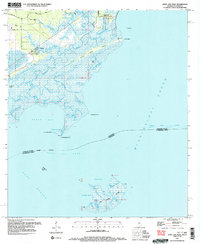
 1998 Chef Menteur1999 Print · USGSThe Louisiana coast near the turn of the millennium shows the intersection of historic defense and modern canal-front living. Trace the ruins of Fort Macomb at Chef Menteur Pass or explore the residential waterways of Venetian Isles.
 - 1998 Map of Chandeleur Light, 2000 Print
 1998 Chandeleur Light2000 Print · USGSThe Louisiana coast at the end of the nineties reveals a fragile maritime landscape of shifting barrier islands. Trace the northern reaches of the Chandeleur Islands to find the Chandeleur Light, Hewes Point, and the Breton National Wildlife Refuge.
 - 1998 Map of New Orleans East, 2000 Print
 1998 New Orleans East2000 Print · USGSNew Orleans and the West Bank are shown at the end of the century, detailing the dense urban fabric and the great bend of the river. Genealogists can trace hundreds of sites including St Louis Cathedral, Metairie Cemetery, and the extensive McDonogh No 26 Sch system.
 - 1998 Map of New Harbor Islands, 2001 Print
 1998 New Harbor Islands2001 Print · USGSThe barrier islands of St. Bernard Parish are captured in the late 1990s as they faced the ongoing challenges of coastal subsidence. Trace the shifting sands of Redfish Point and the remote New Harbor Islands within the Breton National Wildlife Refuge.
Showing maps 1-25 of 32
Top cities of Saint Bernard Parish
Frequently asked questions
- What are the different types of historical maps available for Saint Bernard Parish?
- What is the oldest map of Saint Bernard Parish?
- Where can I purchase historical maps of Saint Bernard Parish for my home or office?
- Where can I download high-res historical maps of Saint Bernard Parish?
- Are there historical topographic maps available for Saint Bernard Parish?
- Is there historical aerial imagery available for Saint Bernard Parish?
- Where are historical maps of Saint Bernard Parish sourced from?