1970s Maps of Vernon Parish, Louisiana
Explore 9 historic maps of Vernon Parish from the 1970s. These maps offer a rare glimpse into what life looked like during the 1970s — showing old roads, neighborhoods, homes, and landmarks that have changed or disappeared over time.
Whether you're researching your family's past, planning a metal detecting trip, or studying how Vernon Parish's landscape evolved across the 1970s, these high-resolution maps are a powerful tool for exploring the history of this region.
- Focus on a specific era: All maps on this page are from the 1970s, giving you a focused view of this time period.
- See what’s changed: Compare century-old streets, trails, and buildings to today's modern landscape using overlays and satellite layers.
- Research with precision: Use these maps for genealogy, historical research, land use analysis, or educational projects.
- View, download, or print: Maps are fully viewable online in high resolution, and can be downloaded or printed for your own records.
Start exploring Vernon Parish's history through authentic maps from the 1970s. This is your window into the past.
Vernon Parish, LA maps
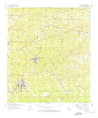
(9)- 1974 Map of Slagle, 1975 Print
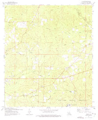 1974 Slagle1975 Print · USGSVernon Parish in the mid-seventies shows a landscape shaped by military expansion and old industrial corridors. Genealogists and historians can trace the foundations of local communities through landmarks like Smart Sch, Self Cem, and the Old Railroad Grade.
 - 1974 Map of Birds Creek, 1975 Print
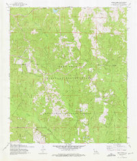 1974 Birds Creek1975 Print · USGSThe Vernon Parish landscape in the 1970s is shaped by the sprawling footprint of the Fort Polk Military Reservation and the Kisatchie National Forest. Researchers can trace old family burial grounds like Watson Cem and military landmarks such as Roosevelt Towers or the Old Railroad Grade.2 unique versions available
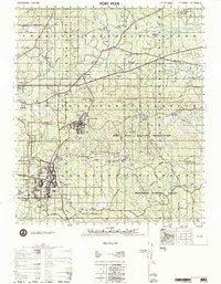
 - 1974 Map of Fort Polk, 1975 Print
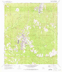 1974 Fort Polk1975 Print · USGSVernon Parish at the height of the mid-seventies reveals a landscape defined by the expansive Fort Polk Military Reservation and national forest lands. Genealogists and historians can trace numerous rural burial sites like Smart Cem and Cemetery Number 7 alongside infrastructure like the Kansas City Southern railroad.3 unique versions available
 - 1974 Map of Simpson South, 1975 Print
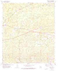 1974 Simpson South1975 Print · USGSIn the piney woods of mid-1970s Vernon Parish, this survey reveals the convergence of rural life and military expansion. Genealogists can trace family roots through the Union Grove Cem, Glass Window Cem, and the historic Schoolhouse near Mayo.2 unique versions available
 - 1974 Map of Fort Polk, 1975 Print
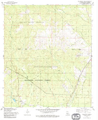
 1974 Fort Polk1975 Print · USGSThe piney woods of Vernon Parish are shown during the mid-seventies, defined by the sprawling Fort Polk Military Reservation and national forest lands. Researchers can find numerous family cemeteries and remote outposts like Slagle, Simpson, and the Zion Hill Cem.
 - 1977 Map of Fort Polk
 1977 Fort Polk1977 Print · USGSVernon Parish in the late seventies shows the massive footprint of the Fort Polk Military Reservation alongside the Kisatchie National Forest. Genealogists and local historians can trace family roots through numerous sites like Antioch Church & Cem and the remote Glass Window Cemetery.
 - 1978 Map of Fullerton Lake, 1979 Print
 1978 Fullerton Lake1979 Print · USGSCentral Louisiana’s piney woods and military training grounds are documented here in the late seventies. Researchers can trace family history at Sermon Cem, locate the Old Railroad Grade, or find the former Fullerton Ch near the lake.
 - 1978 Map of Sieper, 1979 Print
 1978 Sieper1979 Print · USGSRapides and Vernon Parishes come alive in this late-seventies survey of the Louisiana piney woods. Researchers can trace the Calcasieu River and locate family landmarks like Pisgah Ch Cem, Hardshell Cem, and the community of Sieper.
 - 1978 Map of Lacamp, 1979 Print
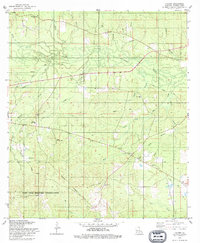 1978 Lacamp1979 Print · USGSVernon Parish in the late seventies is a landscape of creek-fed bottomlands and the expanding footprint of a major army base. Genealogists can locate family sites at Pine Island Cem and Scott Cem, or trace the Old Railroad Grade near Hicks Crossing.
End of results
Showing maps 1-9 of 9
Top cities of Vernon Parish
- Leesville historical maps
- New Llano historical maps
- Rosepine historical maps
- Anacoco historical maps
- Simpson historical maps
- Hornbeck historical maps
Frequently asked questions
- What are the different types of historical maps available for Vernon Parish?
- What is the oldest map of Vernon Parish?
- Where can I purchase historical maps of Vernon Parish for my home or office?
- Where can I download high-res historical maps of Vernon Parish?
- Are there historical topographic maps available for Vernon Parish?
- Is there historical aerial imagery available for Vernon Parish?
- Where are historical maps of Vernon Parish sourced from?