1990s Maps of Vernon Parish, Louisiana
Explore 6 historic maps of Vernon Parish from the 1990s. These maps offer a rare glimpse into what life looked like during the 1990s — showing old roads, neighborhoods, homes, and landmarks that have changed or disappeared over time.
Whether you're researching your family's past, planning a metal detecting trip, or studying how Vernon Parish's landscape evolved across the 1990s, these high-resolution maps are a powerful tool for exploring the history of this region.
- Focus on a specific era: All maps on this page are from the 1990s, giving you a focused view of this time period.
- See what’s changed: Compare century-old streets, trails, and buildings to today's modern landscape using overlays and satellite layers.
- Research with precision: Use these maps for genealogy, historical research, land use analysis, or educational projects.
- View, download, or print: Maps are fully viewable online in high resolution, and can be downloaded or printed for your own records.
Start exploring Vernon Parish's history through authentic maps from the 1990s. This is your window into the past.
Vernon Parish, LA maps
(6)- 1994 Map of Hornbeck, 1996 Print
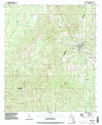 1994 Hornbeck1996 Print · USGSHornbeck and the surrounding parish line territory come into focus in the mid-nineties as the region's infrastructure expanded. Genealogists and researchers can locate family sites like Saint Lukes Cem and Beckham Cem or trace the winding course of Toro Bayou.
 - 1994 Map of Rosepine, 1997 Print
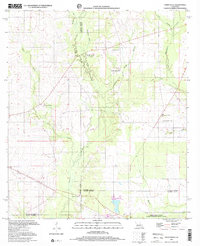
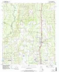 1994 Rosepine1997 Print · USGSRosepine and the northern outskirts of Deridder are captured in the mid-nineties, documenting the transition between Vernon and Beauregard Parishes. Researchers can trace the winding course of the Anacoco River and locate local landmarks such as the Minnow Ponds, Ludington, and Pinewood.
 - 1994 Map of New Llano, 1997 Print
 1994 New Llano1997 Print · USGSVernon Parish at the close of the twentieth century shows a landscape where long-established family cemeteries meet growing residential pockets. Genealogists can trace local roots through landmarks like Gill Cem, Craft Cem, and the communities of Pickering and New Llano.
 - 1994 Map of Leesville, 1997 Print
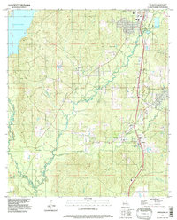
 1994 Leesville1997 Print · USGSLeesville and Vernon Parish appear here in the mid-nineties, showing a landscape shaped by large reservoirs and the Kansas City Southern rail line. Genealogists and local historians can trace the sites of Kay Cem, Shady Grove Cem, and the small community of Anacoco.
 - 1994 Map of Dowden Creek, 1997 Print
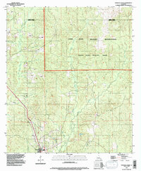 1994 Dowden Creek1997 Print · USGSThe Fort Polk Military Reservation and Peason Ridge Artillery Range define this corner of Louisiana in the mid-1990s. Researchers can trace the drainage of Dowden Creek, locate the settlement of Anacoco, and see the early path of roads then Under Construction.
 - 1997 Map of Steep Gully, 2001 Print
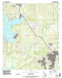
 1997 Steep Gully2001 Print · USGSThe rural pine woods and bayous of Central Louisiana come into focus in the late 1990s as several parish lines converge. Genealogists can trace family connections through sites like Tenmile Cem, Plainview Sch, and the uniquely named Occupy Ch No 1.
End of results
Showing maps 1-6 of 6
Top cities of Vernon Parish
- Leesville historical maps
- New Llano historical maps
- Rosepine historical maps
- Anacoco historical maps
- Simpson historical maps
- Hornbeck historical maps
Frequently asked questions
- What are the different types of historical maps available for Vernon Parish?
- What is the oldest map of Vernon Parish?
- Where can I purchase historical maps of Vernon Parish for my home or office?
- Where can I download high-res historical maps of Vernon Parish?
- Are there historical topographic maps available for Vernon Parish?
- Is there historical aerial imagery available for Vernon Parish?
- Where are historical maps of Vernon Parish sourced from?