1980s Maps of Vernon Parish, Louisiana
Explore 14 historic maps of Vernon Parish from the 1980s. These maps offer a rare glimpse into what life looked like during the 1980s — showing old roads, neighborhoods, homes, and landmarks that have changed or disappeared over time.
Whether you're researching your family's past, planning a metal detecting trip, or studying how Vernon Parish's landscape evolved across the 1980s, these high-resolution maps are a powerful tool for exploring the history of this region.
- Focus on a specific era: All maps on this page are from the 1980s, giving you a focused view of this time period.
- See what’s changed: Compare century-old streets, trails, and buildings to today's modern landscape using overlays and satellite layers.
- Research with precision: Use these maps for genealogy, historical research, land use analysis, or educational projects.
- View, download, or print: Maps are fully viewable online in high resolution, and can be downloaded or printed for your own records.
Start exploring Vernon Parish's history through authentic maps from the 1980s. This is your window into the past.
Vernon Parish, LA maps
(14)- 1984 Map of Evans, 1985 Print
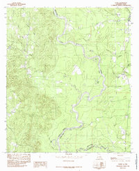 1984 Evans1985 Print · USGSThe Sabine River borderlands in the mid-1980s reveal a landscape shaped by shifting waters and rural settlements. Researchers can trace the oxbows of Evans Old River or locate local landmarks like Stringtown, Almadane, and the Cem near Evans.
 - 1984 Map of Merryville North, 1985 Print
 1984 Merryville North1985 Print · USGSThe Sabine River bottomlands in the early eighties were a network of oxbow lakes and railroad corridors along the Texas border. Researchers can trace the path of the K. C. S. Ry. through Merryville and locate river features like Steamboat Bend and Horseshoe Lake.
 - 1985 Map of Haddens
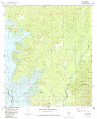
 1985 Haddens1985 Print · USGSThe Sabine River borderlands in the mid-eighties show a landscape shaped by the reservoir and forest. Researchers can locate the Toledo Mission, trace the Bayou Toro drainage, or find family-named sites like Scott Cem and Haddens.2 unique versions available
 - 1985 Map of Toro
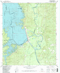
 1985 Toro1985 Print · USGSSabine and Vernon Parishes come into focus in the mid-1980s as the Toledo Bend Reservoir reshapes the Louisiana-Texas border. Researchers can trace old family sites and rural landmarks like Victoria Cem, Little Flock Ch, and the settlement of Toro.
 - 1985 Map of Wiergate SE
 1985 Wiergate SE1985 Print · USGSThe Sabine River bottomlands on the Texas-Louisiana border are shown here in the mid-1980s, revealing a landscape defined by oxbow lakes and rural homesteads. Trace the history of the area through family-named sites like Gunter Cem and the Burr Ferry Bridge.2 unique versions available
 - 1986 Map of Rosepine
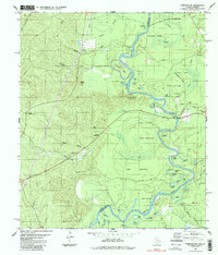
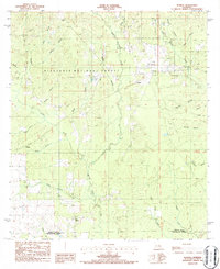
 1986 Rosepine1986 Print · USGSThe Vernon and Beauregard Parish line comes into focus in the mid-1980s, showcasing the rural landscape surrounding Rosepine and De Ridder. Researchers can trace old gravel operations at the Gravel Pits or locate local landmarks like the Cem and Ludington.2 unique versions available
 - 1986 Map of Hurricane Branch
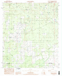 1986 Hurricane Branch1986 Print · USGSThe pine forests of western Louisiana are captured in the mid-1980s, documenting a landscape of logging roads and isolated rural life. Genealogists and historians can locate family Cem sites and trace old paths near Bundick Creek or Hurricane Branch.
 - 1986 Map of Sugrue
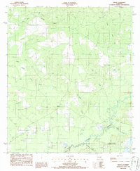
 1986 Sugrue1986 Print · USGSWithin the pine woods of Vernon Parish in the mid-1980s, these forest lands reveal scattered settlements and rural landmarks. Researchers can trace local homesteads and industry through labels for Cole Central, the Gravel Pit, and the winding Whisky Chitto Creek.2 unique versions available
 - 1986 Map of DeRidder
 1986 DeRidder1986 Print · USGSThe Louisiana-Texas borderlands come to life in the mid-eighties, showcasing the timber country and rail corridors of the Sabine River valley. Researchers can trace the legacy of small communities and transit lines through Merryville, Holly Springs, and the Missouri Pacific railroad.2 unique versions available
 - 1986 Map of Knight
 1986 Knight1986 Print · USGSVernon and Beauregard Parishes are captured here in the mid-1980s, revealing a landscape of dense creek networks and small timber-country settlements. Genealogists and local historians can trace landmarks like Knight and Fal or map the reaches of Bayou Anacoco and Damrel Creek.
 - 1986 Map of Ville Platte
 1986 Ville Platte1986 Print · USGSCentral Louisiana in the 1980s reveals a complex landscape of pine forests and bayou networks spanning seven distinct parishes. Researchers can trace historic rail lines like the Atchison Topeka and Santa Fe RR and locate settlements such as Simmons Settlement, Redland, and Elizabeth.2 unique versions available
 - 1986 Map of Alexandria
 1986 Alexandria1986 Print · USGSCentral Louisiana in the mid-eighties shows a landscape of strategic military installations and deep river-valley agriculture. Researchers can trace the footprints of England Air Force Base, Camp Beauregard, and the extensive Kisatchie National Forest.2 unique versions available
 - 1986 Map of Neale
 1986 Neale1986 Print · USGSIn the piney woods and wetlands along the Beauregard-Vernon Parish border in the 1980s, industry meets the bayou. Genealogists and researchers can trace the industrial footprint of Neale through its Refinery, Oil and Gas Field, and the Fire Break network.
 - 1986 Map of Leesville, 1988 Print
 1986 Leesville1988 Print · USGSThe Louisiana-Texas borderlands in the mid-eighties centered on the vast Toledo Bend Reservoir and the timber-rich piney woods. Researchers can trace the Kansas City Southern RR corridor or locate old communities like Wiergate, Rosevine, and Sandel.
End of results
Showing maps 1-14 of 14
Top cities of Vernon Parish
- Leesville historical maps
- New Llano historical maps
- Rosepine historical maps
- Anacoco historical maps
- Simpson historical maps
- Hornbeck historical maps
Frequently asked questions
- What are the different types of historical maps available for Vernon Parish?
- What is the oldest map of Vernon Parish?
- Where can I purchase historical maps of Vernon Parish for my home or office?
- Where can I download high-res historical maps of Vernon Parish?
- Are there historical topographic maps available for Vernon Parish?
- Is there historical aerial imagery available for Vernon Parish?
- Where are historical maps of Vernon Parish sourced from?