1930s Maps of Penobscot County, Maine
Explore 19 historic maps of Penobscot County from the 1930s. These maps offer a rare glimpse into what life looked like during the 1930s — showing old roads, neighborhoods, homes, and landmarks that have changed or disappeared over time.
Whether you're researching your family's past, planning a metal detecting trip, or studying how Penobscot County's landscape evolved across the 1930s, these high-resolution maps are a powerful tool for exploring the history of this region.
- Focus on a specific era: All maps on this page are from the 1930s, giving you a focused view of this time period.
- See what’s changed: Compare century-old streets, trails, and buildings to today's modern landscape using overlays and satellite layers.
- Research with precision: Use these maps for genealogy, historical research, land use analysis, or educational projects.
- View, download, or print: Maps are fully viewable online in high resolution, and can be downloaded or printed for your own records.
Start exploring Penobscot County's history through authentic maps from the 1930s. This is your window into the past.
Penobscot County, ME maps
(19)- 1930 Map of Katahdin
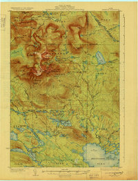 1930 Katahdin1930 Print · USGSBackcountry Maine in the late 1920s offered a rugged landscape of newly surveyed trails and remote outposts. You can trace the early paths to Mount Katahdin and locate historic sites like Sewell Camp, Katahdin Lake Camp, and New City.6 unique versions available
 - 1930 Map of Pittsfield
 1930 Pittsfield1930 Print · USGSSomerset County in the early thirties reveals a network of farming hamlets and lakeside communities connected by rail and river. Genealogists can trace family names through landmarks like Todds Corner West Ripley PO, Nutter Cemetery, and Town Farm Sch.
 - 1931 Map of Springfield
 1931 Springfield1931 Print · USGSPenobscot and Washington counties in the early 1930s reveal a landscape of ridges, bogs, and scattered timber camps. Genealogists can trace early rural life through features like Poplar Tavern Camp, the Dill Ridge Fire Tower, and numerous district schools like Cole Sch.4 unique versions available
 - 1931 Map of Stetson
 1931 Stetson1931 Print · USGSPenobscot County townships like Stetson and Exeter were thriving rural communities in the early thirties before modern school consolidation. Genealogists can locate family homesteads near numerous local landmarks like the Holy Rollers Sch, Exeter Fairgrounds, and Damascus Sta.
 - 1931 Map of Saponac
 1931 Saponac1931 Print · USGSThe Maine wilderness of the early thirties is captured here before modern development, spanning the border of Penobscot and Hancock counties. Researchers can trace rural life through the locations of the Greenfield Cemetery, the Morrison Mill, and several district schools like School No 1.
 - 1932 Map of Brooks
 1932 Brooks1932 Print · USGSWaldo and Penobscot counties are shown here in the late twenties, organized around a series of hill peaks and the Belfast and Moosehead Lake RR. Researchers can locate dozens of country schools and mills, from Rollins Mills and Nickerson Mills to the East Thorndike Ch.3 unique versions available
 - 1932 Map of Dover-Foxcroft
 1932 Dover-Foxcroft1932 Print · USGSPiscataquis and Penobscot counties are shown here in the early 1930s, a landscape defined by the Piscataquis River and rail-fed mill towns. Genealogists can trace family names through dozens of rural landmarks like Hurd Corner, Gould Cemetery, and the Higgins Classical Institute.4 unique versions available
 - 1932 Map of Nicatous Lake
 1932 Nicatous Lake1932 Print · USGSNicatous Lake and the surrounding Maine wilderness are captured here in the early 1930s, when private sporting retreats and seasonal camps dotted the shoreline. Genealogists and local historians can trace specific locations like the Explorers Club, Adler Tavern Camp, and Sullivan Camp.4 unique versions available
 - 1932 Map of Pittsfield
 1932 Pittsfield1932 Print · USGSMaine's Sebasticook Valley thrived in the early 1930s as a hub of rail transport and rural commerce. Genealogists and historians can trace the many family-named schoolhouses and crossroads, from Lincoln Mills and Dixie Corner to the Wing Cemetery.3 unique versions available
 - 1932 Map of Great Pond
 1932 Great Pond1932 Print · USGSHancock and Penobscot Counties are captured here in the early thirties, showcasing the timberlands and small settlements along the Airline Road. Local historians can trace family roots through sites like the Goodwin School, Archers Corners, and North Mariaville.4 unique versions available
 - 1933 Map of Boyd Lake
 1933 Boyd Lake1933 Print · USGSPenobscot County communities and the Piscataquis River valley are captured here in the early thirties as the railroad remained the lifeblood of rural Maine. Local historians can trace numerous family-named landmarks and district schoolhouses like Knowles Sch, Ridge Sch, and the Huntington Mill works.
 - 1933 Map of Pittsfield
 1933 Pittsfield1933 Print · USGSSomerset County in the early 1930s is a landscape of river-driven towns and remote farm schools connected by the Maine Central rail lines. Genealogy researchers can trace family landmarks like Goodwin Corner, the Wing Cemetery, and over a dozen schoolhouses including Merrill Sch.2 unique versions available
 - 1933 Map of Guilford, 1958 Print
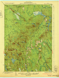
 1933 Guilford1958 Print · USGSPiscataquis County townships thrive along the river and rail lines of central Maine in the early thirties. Local historians can trace the foundations of Guilford, locate rural landmarks like Spooners Mill, and find family heritage at Storer Cem or Abbot Village Sta.5 unique versions available
 - 1934 Map of Saponac
 1934 Saponac1934 Print · USGSPenobscot County was a landscape of small mill towns and mountain ridges in the 1930s. Researchers can locate early district schools like Longfellow Sch, industrial sites such as Morrison Mill, and family landmarks including Crocker Turn.3 unique versions available
 - 1934 Map of Nicatous Lake
 1934 Nicatous Lake1934 Print · USGSHancock County was a landscape of remote sporting camps and timber trails in the early 1930s. Genealogists and historians can trace old sites like Poplar Tavern Camp, the Nicatous Club, and No 2 Camp set among landmarks like Duck Mtn.4 unique versions available
 - 1934 Map of Springfield
 1934 Springfield1934 Print · USGSPenobscot County in the 1930s is a landscape of rural schoolhouses and timberlands surrounding Springfield and Carroll. Genealogists and historians can trace family-named locations such as Tolman Sch, Gowell Sch, and Bridge Farm.4 unique versions available
 - 1935 Map of Dover-Foxcroft
 1935 Dover-Foxcroft1935 Print · USGSThe Piscataquis River valley of central Maine is shown here in the 1930s, centered on the mill town of Dover-Foxcroft. Genealogists can trace family names at Rollins Mill, Foss Cem, and dozens of rural schoolhouses like Morrison Sch.2 unique versions available
 - 1935 Map of Stetson
 1935 Stetson1935 Print · USGSPenobscot County townships show their early twentieth-century character in this 1930s survey of central Maine. Genealogists and local historians can trace schoolhouse locations like Partridge Sch and rail-line settlements such as Etna and Carmel.3 unique versions available
 - 1937 Map of Guilford
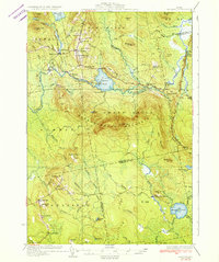
 1937 Guilford1937 Print · USGSPiscataquis County industry and rural life are captured here in the mid-1930s as the river-and-rail economy thrived. Genealogists can trace family roots through numerous local schoolhouses and landmarks like Spooners Mill, Lows Bridge, and the Wassookeag Cem.2 unique versions available
End of results
Showing maps 1-19 of 19
Top cities of Penobscot County
- Bangor historical maps
- Orono historical maps
- Brewer historical maps
- Hampden historical maps
- Old Town historical maps
- Hermon historical maps
See more
Frequently asked questions
- What are the different types of historical maps available for Penobscot County?
- What is the oldest map of Penobscot County?
- Where can I purchase historical maps of Penobscot County for my home or office?
- Where can I download high-res historical maps of Penobscot County?
- Are there historical topographic maps available for Penobscot County?
- Is there historical aerial imagery available for Penobscot County?
- Where are historical maps of Penobscot County sourced from?