1970s Maps of Penobscot County, Maine
Explore 83 historic maps of Penobscot County from the 1970s. These maps offer a rare glimpse into what life looked like during the 1970s — showing old roads, neighborhoods, homes, and landmarks that have changed or disappeared over time.
Whether you're researching your family's past, planning a metal detecting trip, or studying how Penobscot County's landscape evolved across the 1970s, these high-resolution maps are a powerful tool for exploring the history of this region.
- Focus on a specific era: All maps on this page are from the 1970s, giving you a focused view of this time period.
- See what’s changed: Compare century-old streets, trails, and buildings to today's modern landscape using overlays and satellite layers.
- Research with precision: Use these maps for genealogy, historical research, land use analysis, or educational projects.
- View, download, or print: Maps are fully viewable online in high resolution, and can be downloaded or printed for your own records.
Start exploring Penobscot County's history through authentic maps from the 1970s. This is your window into the past.
Penobscot County, ME maps
(83)- 1975 Map of The Traveler
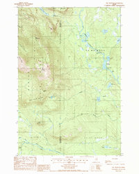 1975 The Traveler1975 Print · USGSBaxter State Park and the surrounding wildlands of the Maine North Woods appear in high detail during the mid-1980s. Trace the mountain geography from The Traveler to Old City, or follow the river system through Stair Falls and the Haskell Deadwater.2 unique versions available
 - 1975 Map of Millinocket SW, 1979 Print
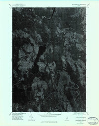 1975 Millinocket SW1979 Print · USGSPenobscot County timberlands and remote waters are captured in this mid-1970s aerial survey. Sportsmen and researchers can trace the detailed shorelines and forest tracks surrounding Nollesemic Lake and the West Branch Penobscot River.2 unique versions available
 - 1975 Map of Island Falls SW, 1980 Print
 1975 Island Falls SW1980 Print · USGSPenobscot County timberlands and farms are captured here in the mid-1970s through high-altitude aerial photography. Researchers can trace land-use patterns and property boundaries near Patten and Halls Corner, or locate landmarks like Crystal Lake.
 - 1975 Map of Stetson SW, 1980 Print
 1975 Stetson SW1980 Print · USGSPenobscot County agriculture and woodlots are captured in this mid-seventies aerial survey of the region. Researchers can trace the layout of East Newport and Plymouth while identifying the precise shoreline of Sebasticook Lake.
 - 1975 Map of Shin Pond NE, 1980 Print
 1975 Shin Pond NE1980 Print · USGSThe deep Maine woods in northern Penobscot County appear in this mid-seventies orthophotograph, capturing a remote landscape shaped by timber and water. Researchers can trace the winding course of the Seboeis River and a small Brook through the dense forest canopy.
 - 1975 Map of Pittsfield NE, 1980 Print
 1975 Pittsfield NE1980 Print · USGSSomerset County, Maine, is shown in high detail during the mid-seventies through this aerial orthophotograph. Researchers can trace rural family-named crossroads like Pleasant Vale Corner and Sanborn Corner or the path of the Mulligan Stream.
 - 1975 Map of Lincoln NW, 1980 Print
 1975 Lincoln NW1980 Print · USGSPenobscot County’s deep woods and glacial lakes are captured in this mid-seventies aerial survey of the Maine wilderness. Researchers can trace the timber-hauling networks around Mattamiscontis Mountain or study the shorelines of Mattamiscontis Lake and South Branch Lake.
 - 1975 Map of Mattawamkeag NW, 1980 Print
 1975 Mattawamkeag NW1980 Print · USGSThe Maine timberlands near Penobscot are documented here in the mid-1970s through detailed aerial imagery of the dense forest canopy. Genealogists and environmental researchers can trace the natural shoreline of Salmon Stream Lake and the paths of Wyman Brook.
 - 1975 Map of Sherman SW, 1980 Print
 1975 Sherman SW1980 Print · USGSSouthern Penobscot County is shown in the mid-1970s, revealing the traditional layout of Maine's timber and farming communities. Genealogists can trace the rural crossroads and property boundaries near Benedicta, Sherman Mills, and Plunkett Pond.
 - 1975 Map of Wytopitlock SE, 1980 Print
 1975 Wytopitlock SE1980 Print · USGSMaine's interior timberlands are captured in high-altitude detail during the mid-seventies, showing the intersection of water and forest management. Trace the precise 1975 shoreline of the Mattawamkeag River and the winding course of Meadow Brook.
 - 1975 Map of Wytopitlock NW, 1980 Print
 1975 Wytopitlock NW1980 Print · USGSAroostook County's timberlands are shown in detail during the mid-seventies, revealing the intersection of forest and water. Researchers can trace the winding Macwahoc Stream and the corridor near Reed as they appeared decades ago.
 - 1975 Map of Wytopitlock SW, 1980 Print
 1975 Wytopitlock SW1980 Print · USGSThe settlement of Kingman and the winding Mattawamkeag River are shown here during the mid-seventies. Researchers can trace the drainage patterns and historical woodlots along Molunkus Stream and Mattagodus Stream.
 - 1975 Map of Scraggly Lake SW, 1980 Print
 1975 Scraggly Lake SW1980 Print · USGSCovers Penobscot County, including Carroll Plantation, Pukakon Township, and other nearby areas
 - 1975 Map of Springfield NW, 1980 Print
 1975 Springfield NW1980 Print · USGSPenobscot County timberlands and remote clearings are captured here in the mid-1970s, showing the intersection of forest and farm. Genealogists and local historians can trace the footprint of SPRINGFIELD and identify landmarks like WEBSTER POND and MATTAKEUNK.
 - 1975 Map of Winn SW, 1980 Print
 1975 Winn SW1980 Print · USGSPenobscot County is seen through high-resolution aerial photography in the mid-1970s, capturing the dense forest and water networks of the Maine interior. Researchers can examine the detailed shorelines and surrounding timberland of Eskutassis Pond.
 - 1975 Map of Saponac SW, 1980 Print
 1975 Saponac SW1980 Print · USGSThe rural Maine woods around Greenfield are captured in high detail during the mid-seventies. Local historians and land-use researchers can trace the specific boundaries of clearings, forest tracks, and early structures within the Greenfield settlement area.
 - 1975 Map of Nicatous Lake NW, 1980 Print
 1975 Nicatous Lake NW1980 Print · USGSHancock County’s deep woods and waters are captured in the mid-1970s through this detailed aerial survey. Researchers can trace the winding Passadumkeag River and study the intricate shoreline of Nicatous Lake and the nearby Heath.
 - 1975 Map of Winn NE, 1980 Print
 1975 Winn NE1980 Print · USGSThe dense forests of Penobscot County are captured in this mid-seventies aerial survey of Northern Maine. Researchers can trace the winding course of the Mattawamkeag River and examine the layout of the settlement at WINN.
 - 1975 Map of Stetson NW, 1980 Print
 1975 Stetson NW1980 Print · USGSPenobscot County crossroads appear in this mid-seventies aerial survey, showing the literal layout of central Maine's farmsteads and forests. Genealogists and local researchers can trace old property boundaries and rural roads near Stetson, Exeter Center, and Spragues Mill.
 - 1975 Map of Burnham NE, 1980 Print
 1975 Burnham NE1980 Print · USGSWaldo County's rural landscape is captured from above in the mid-1970s, revealing the intricate patterns of forest and farmland. Researchers can trace the layout of small settlements like Greens Corner and Reynolds Corner near the shores of Unity Pond.
 - 1975 Map of Brooks NW, 1980 Print
 1975 Brooks NW1980 Print · USGSMid-seventies central Maine comes into sharp focus in this aerial survey of Penobscot and Waldo Counties. Researchers can trace rural property lines and woodlots surrounding North Dixmont, East Troy, and the slopes of Mount Harris.
 - 1975 Map of Sherman NW, 1980 Print
 1975 Sherman NW1980 Print · USGSPenobscot County, Maine, is captured in this mid-1970s aerial survey, showing the agricultural heart of the region. Researchers can trace the layout of northern settlements like Patten and Sherman Station alongside the East Branch Molunkus Stream.
 - 1975 Map of Island Falls NW, 1980 Print
 1975 Island Falls NW1980 Print · USGSThe Maine woods near Island Falls are captured in the mid-1970s via high-altitude aerial photography. Trace the literal shorelines of Rockabema Lake and Pleasant Lake or locate the remote peaks of Green Mtn and Pickett Mtn.
 - 1975 Map of Stacyville NW, 1980 Print
 1975 Stacyville NW1980 Print · USGSPenobscot County, Maine, is captured in the mid-1970s through this aerial orthophotograph focused on the upper Penobscot watershed. Researchers can trace the winding East Branch Penobscot River and the confluence of the Wassataquoik Stream near Lunksoos Mountain.
 - 1975 Map of Millinocket NE, 1980 Print
 1975 Millinocket NE1980 Print · USGSThe industrial and river landscape of northern Maine is captured in the mid-seventies just as the timber industry's footprint remained dominant. Researchers can trace the developed grid of East Millinocket and the waters of Dolby Pond and Grindstone.
Showing maps 1-25 of 83
Top cities of Penobscot County
- Bangor historical maps
- Orono historical maps
- Brewer historical maps
- Hampden historical maps
- Old Town historical maps
- Hermon historical maps
See more
Frequently asked questions
- What are the different types of historical maps available for Penobscot County?
- What is the oldest map of Penobscot County?
- Where can I purchase historical maps of Penobscot County for my home or office?
- Where can I download high-res historical maps of Penobscot County?
- Are there historical topographic maps available for Penobscot County?
- Is there historical aerial imagery available for Penobscot County?
- Where are historical maps of Penobscot County sourced from?