1990s Maps of Penobscot County, Maine
Explore 6 historic maps of Penobscot County from the 1990s. These maps offer a rare glimpse into what life looked like during the 1990s — showing old roads, neighborhoods, homes, and landmarks that have changed or disappeared over time.
Whether you're researching your family's past, planning a metal detecting trip, or studying how Penobscot County's landscape evolved across the 1990s, these high-resolution maps are a powerful tool for exploring the history of this region.
- Focus on a specific era: All maps on this page are from the 1990s, giving you a focused view of this time period.
- See what’s changed: Compare century-old streets, trails, and buildings to today's modern landscape using overlays and satellite layers.
- Research with precision: Use these maps for genealogy, historical research, land use analysis, or educational projects.
- View, download, or print: Maps are fully viewable online in high resolution, and can be downloaded or printed for your own records.
Start exploring Penobscot County's history through authentic maps from the 1990s. This is your window into the past.
Penobscot County, ME maps
(6)- 1994 Map of Dover-Foxcroft
 1994 Dover-Foxcroft1994 Print · USGSCentral Maine in the mid-nineties shows a landscape of timber-driven towns and deep glacial lakes. Trace the paths of the Canadian Pacific RR or locate the Moscow Air Force Station Transmit Site and Sebec Lake.
 - 1994 Map of Calais
 1994 Calais1994 Print · USGSEastern Maine's river and lake country comes into focus in the 1990s, centered on the international border at Calais and the vast Passamaquoddy Indian Reservation. Researchers can trace the water-linked settlements of Grand Lake Stream, the airfield at Princeton Airport, and the industrial heritage of Woodland.
 - 1994 Map of Bangor
 1994 Bangor1994 Print · USGSThe Penobscot River valley and the coastal highlands of eastern Maine are captured here in the mid-1990s. Researchers can trace the industrial rail corridors of the Maine Central Railroad or explore the landscape around Old Town, Bucksport, and Graham Lake.
 - 1994 Map of Oakfield
 1994 Oakfield1994 Print · USGSAroostook County's North Woods and rural settlements are shown here in the mid-1990s, capturing the region's transition from forest to farmland. Trace the path of the Bangor and Aroostook RR through Smyrna Mills or locate landings on Millinocket Lake.
 - 1996 Map of Bangor, 2000 Print
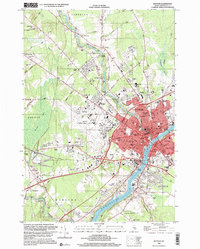 1996 Bangor2000 Print · USGSBangor and the Penobscot River valley are captured in the mid-nineties, showing a landscape defined by collegiate growth and aviation infrastructure. Researchers can trace the development of Husson College and the Bangor International Airport alongside landmarks like Northern Maine Junction.
 - 1998 Map of Old Town, 2001 Print
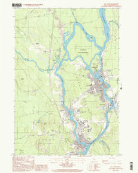 1998 Old Town2001 Print · USGSThe Penobscot River valley near the turn of the millennium shows a landscape defined by its island settlements and university influence. Researchers can trace the layout of the Penobscot Indian Reservation or locate landmarks like Dewitt Field and the Univ of Maine.
End of results
Showing maps 1-6 of 6
Top cities of Penobscot County
- Bangor historical maps
- Orono historical maps
- Brewer historical maps
- Hampden historical maps
- Old Town historical maps
- Hermon historical maps
See more
Frequently asked questions
- What are the different types of historical maps available for Penobscot County?
- What is the oldest map of Penobscot County?
- Where can I purchase historical maps of Penobscot County for my home or office?
- Where can I download high-res historical maps of Penobscot County?
- Are there historical topographic maps available for Penobscot County?
- Is there historical aerial imagery available for Penobscot County?
- Where are historical maps of Penobscot County sourced from?