1940s Maps of Penobscot County, Maine
Explore 25 historic maps of Penobscot County from the 1940s. These maps offer a rare glimpse into what life looked like during the 1940s — showing old roads, neighborhoods, homes, and landmarks that have changed or disappeared over time.
Whether you're researching your family's past, planning a metal detecting trip, or studying how Penobscot County's landscape evolved across the 1940s, these high-resolution maps are a powerful tool for exploring the history of this region.
- Focus on a specific era: All maps on this page are from the 1940s, giving you a focused view of this time period.
- See what’s changed: Compare century-old streets, trails, and buildings to today's modern landscape using overlays and satellite layers.
- Research with precision: Use these maps for genealogy, historical research, land use analysis, or educational projects.
- View, download, or print: Maps are fully viewable online in high resolution, and can be downloaded or printed for your own records.
Start exploring Penobscot County's history through authentic maps from the 1940s. This is your window into the past.
Penobscot County, ME maps
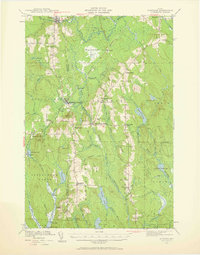
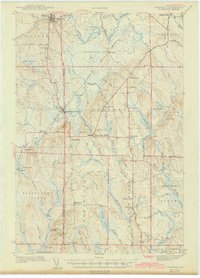
(25)- 1940 Map of Island Falls, 1957 Print
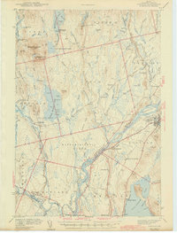
 1940 Island Falls1957 Print · USGSThe river-and-rail landscape of southern Aroostook County is captured here in the years before the war. Researchers can trace the exact locations of numerous rural schoolhouses like Allsbury Sch and Myrick Sch or locate the Bangor and Aroostook RR through Island Falls.4 unique versions available
 - 1940 Map of Sherman, 1959 Print
 1940 Sherman1959 Print · USGSNorthern Maine's timber and rail landscape is captured here just before the mid-century, centered on the Bangor and Aroostook line. Genealogists can trace early homesteads near Sherman Mills, Golden Ridge, and the Stacyville Post Office.2 unique versions available
 - 1940 Map of Oxbow, 1960 Print
 1940 Oxbow1960 Print · USGSAroostook County was a remote timber and river frontier when this survey was conducted in the early 1940s. Genealogists and historians can trace old homesteads around Oxbow, locate the Oxbow East End School, and follow the Loghauler Road through the woods.
 - 1940 Map of Mattawamkeag, 1961 Print
 1940 Mattawamkeag1961 Print · USGSThe rail junction at Mattawamkeag and the timber-rich Penobscot valley are captured here just before the mid-century. Genealogists and historians can trace family locations at Jordan Mills, identify the Back Settlement, and locate the North Woodville School.2 unique versions available
 - 1941 Map of Scraggly Lake
 1941 Scraggly Lake1941 Print · USGSBaskahegan Lake and the surrounding Maine timberlands are captured here in the early 1940s, showing a landscape defined by water and woods. Genealogists and researchers can trace remote landmarks like the FIRETOWER on Musquash Mountain or the old route of Gentner Road.6 unique versions available
 - 1941 Map of Wytopitlock, 1960 Print
 1941 Wytopitlock1960 Print · USGSAroostook County was a landscape of remote timberlands and river-side rail hubs at the start of the 1940s. Genealogists and historians can trace old community life through landmarks like Knoxville Sch, Whitney Fire Tower, and the rail junction at Wytopitlock.2 unique versions available
 - 1942 Map of Lincoln
 1942 Lincoln1942 Print · USGSPenobscot River life and the timber-driven rail economy are captured here during the early years of the war. Genealogists and historians can locate old landmarks like Merrifield Sch, the Ridge Cem, and the river island communities of the Penobscot Indian Reservation.3 unique versions available
 - 1942 Map of Orland
 1942 Orland1942 Print · USGSIn the early 1940s, the rugged interior between the Penobscot River and Ellsworth was a landscape of high summits and conservation-focused industry. Genealogists and historians can trace old homesteads and landmarks like Bucks Mills, the U S Fish Hatchery, and the scattered settlements of East Orland and North Ellsworth.
 - 1942 Map of Island Falls
 1942 Island Falls1942 Print · USGSNorthern Maine's timber and rail frontier comes into focus in the early 1940s as the Bangor and Aroostook RR connects the woods to the world. Genealogists and historians can trace numerous rural schoolhouses like Rockabema Sch and the storied Patten Academy among the hills of Mount Chase.
 - 1942 Map of Bangor
 1942 Bangor1942 Print · USGSThe Penobscot River valley thrives in this early-forties survey of the region's industrial and rural heart. Trace the historic street plans of Bangor and Brewer or locate family homesteads near Leather Corner and Snow Corner.
 - 1942 Map of Mattawamkeag
 1942 Mattawamkeag1942 Print · USGSMaine's logging and rail heartland is captured here during the early 1940s at the junction of the Penobscot and Mattawamkeag rivers. Researchers can trace the heritage of remote outposts like Jordan Mills and Back Settlement or locate the North Woodville Sch.3 unique versions available
 - 1942 Map of Oxbow
 1942 Oxbow1942 Print · USGSNorthern Maine's timber and rail landscape is captured here during the early 1940s, centered on the river-bound community of Oxbow. Genealogists can locate Willard Cem, East End Sch, and remote logging outposts like Camp Violette.2 unique versions available
 - 1942 Map of Bucksport
 1942 Bucksport1942 Print · USGSThe mid-century Penobscot River valley is captured here just as the river-and-rail economy defined local life. Genealogists and historians can trace family-named crossroads like Nealeys Corner and Ellingwoods Corner or locate the landmark Fort Knox and Prospect Ferry.
 - 1942 Map of Sherman
 1942 Sherman1942 Print · USGSSouthern Aroostook County is captured here just before the mid-century, showcasing the railroad-dependent communities of Sherman and Patten. Genealogists can locate family sites near the Sherman Mills Cem, Doble Sch, or the now-quiet rail stops at Sherman Station.
 - 1943 Map of Wytopitlock
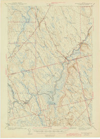 1943 Wytopitlock1943 Print · USGSMaine’s timber and rail country comes to life in the early 1940s as the Mattawamkeag River valley connects isolated townships. Researchers can trace rural life through the locations of Knoxville Sch, Drew Cem, and the prominent Whitney Fire Tower.
 - 1944 Map of Scraggly Lake
 1944 Scraggly Lake1944 Print · USGSThe timberlands and interconnected waterways of eastern Maine are captured here in the early 1940s. Genealogists and historians can trace the remote township boundaries of Topsfield and Talmadge or locate landmarks like Black Cat Rips and Musquash Mountain.
 - 1944 Map of Orono, 1954 Print
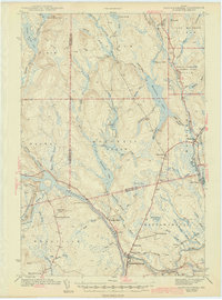
 1944 Orono1954 Print · USGSThe Penobscot River corridor is captured here in the mid-1940s, showing the early footprint of the University of Maine and the industrial activity of Old Town. Genealogists and historians can trace family locations through French Settlement, Woodlawn Cem, and the Old Gold Mine.2 unique versions available
 - 1946 Map of Bangor
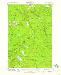
 1946 Bangor1946 Print · USGSBangor and the Penobscot River are captured here in the mid-1940s, showing a critical hub of rail transport and military aviation. Local historians can trace the development of Dow Field, find local schools like Tennyson Sch, or locate family plots in Lakeview Cem.3 unique versions available
 - 1946 Map of Orono
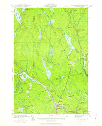
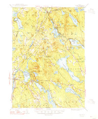
 1946 Orono1946 Print · USGSPenobscot County industry and academia meet along the river in the mid-forties. Genealogists and historians can trace the development of Marsh Island, locate the University of Maine campus, and find local landmarks like the Old Gold Mine Trail.2 unique versions available
 - 1947 Map of Schoodic, 1956 Print
 1947 Schoodic1956 Print · USGSPiscataquis County in the late 1940s is shown here as a landscape of timber, rail, and isolated lake settlements. Genealogists and historians can trace old homesteads and landmarks like Evergreen Cem, the Maxfield Sch, and the rail stops at Packards or Lake View.3 unique versions available
 - 1948 Map of Bangor
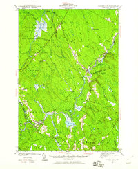
 1948 Bangor1948 Print · USGSThe Maine coast and its industrial river valleys are captured here shortly after the war, showing the vital shipping and rail hubs of the late 1940s. Genealogists and historians can trace the tracks of the Maine Central RR connecting Bangor, Augusta, and Old Town.
 - 1948 Map of Bucksport
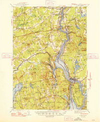 1948 Bucksport1948 Print · USGSMid-coast Maine at the end of the 1940s reveals a bustling corridor of river commerce and rail transport along the Penobscot River. Researchers can trace old family lines at Wiswell Cem, locate the historic Fort Knox State Park, and follow the tracks of the Bangor and Aroostook through towns like Winterport.2 unique versions available
 - 1948 Map of Orland
 1948 Orland1948 Print · USGSHancock and Penobscot counties are shown here just after the war, when rural hamlets and lakeside retreats defined the landscape. Researchers can locate the Annear Copper Mine, the US Fish Hatchery, and numerous family burial grounds like Evergreen Cemetery.2 unique versions available
 - 1949 Map of Schoodic
 1949 Schoodic1949 Print · USGSThe rail-and-river network of central Maine is captured here just after the war, showing the junction of two major rail lines. Genealogists and historians can trace old community sites like Lake View, Knights Landing, and the Maxfield Sch.2 unique versions available
 - 1949 Map of Katahdin, 1955 Print
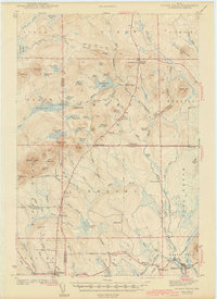
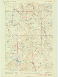
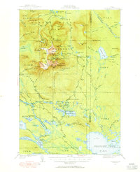 1949 Katahdin1955 Print · USGSThe Maine North Woods in the late 1940s centers on the rise of Baxter State Park and the towering peak of Mount Katahdin. Researchers can trace early backcountry infrastructure like Joe Francis Camp, the Tote Road, and the original Abol Campsite.10 unique versions available
End of results
Showing maps 1-25 of 25
Top cities of Penobscot County
- Bangor historical maps
- Orono historical maps
- Brewer historical maps
- Hampden historical maps
- Old Town historical maps
- Hermon historical maps
See more
Frequently asked questions
- What are the different types of historical maps available for Penobscot County?
- What is the oldest map of Penobscot County?
- Where can I purchase historical maps of Penobscot County for my home or office?
- Where can I download high-res historical maps of Penobscot County?
- Are there historical topographic maps available for Penobscot County?
- Is there historical aerial imagery available for Penobscot County?
- Where are historical maps of Penobscot County sourced from?