1980s Maps of Penobscot County, Maine
Explore 101 historic maps of Penobscot County from the 1980s. These maps offer a rare glimpse into what life looked like during the 1980s — showing old roads, neighborhoods, homes, and landmarks that have changed or disappeared over time.
Whether you're researching your family's past, planning a metal detecting trip, or studying how Penobscot County's landscape evolved across the 1980s, these high-resolution maps are a powerful tool for exploring the history of this region.
- Focus on a specific era: All maps on this page are from the 1980s, giving you a focused view of this time period.
- See what’s changed: Compare century-old streets, trails, and buildings to today's modern landscape using overlays and satellite layers.
- Research with precision: Use these maps for genealogy, historical research, land use analysis, or educational projects.
- View, download, or print: Maps are fully viewable online in high resolution, and can be downloaded or printed for your own records.
Start exploring Penobscot County's history through authentic maps from the 1980s. This is your window into the past.
Penobscot County, ME maps
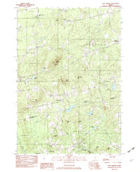
(101)- 1981 Map of Snow Mountain, 1982 Print
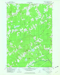
 1981 Snow Mountain1982 Print · USGSRural Penobscot and Waldo Counties come into focus during the late 1970s, showcasing a landscape of timbered hills and crossroads hamlets. Genealogists and local historians can trace family locations near Newburgh Village, Twining Cem, and the old Winterport Sta railroad stop.
 - 1981 Map of West Corinth, 1982 Print
 1981 West Corinth1982 Print · USGSPenobscot County agriculture and small-town life are preserved in this early 1980s survey of the Corinth and Exeter area. Researchers can trace family history through local landmarks like Exeter Mills, the Morrison Sch, and the Corinthian Cem near East Corinth.
 - 1982 Map of Brewer Lake
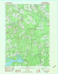
 1982 Brewer Lake1982 Print · USGSHancock County's landscape of ridges and ponds is captured here in the early eighties as rural life centered around towns like Dedham and East Holden. Genealogists can locate several local burial grounds, including Union Cem and Copeland Hill Cem, and trace the path of the Maine Central railroad.
 - 1982 Map of Hampden
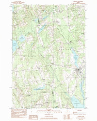
 1982 Hampden1982 Print · USGSThe Penobscot River valley in the early eighties shows a landscape of growing riverside towns and historic upland settlements. Genealogists can locate family landmarks from Dorothea Dix Park to several burying grounds including Riverview Cem and Evergreen Cem.
 - 1982 Map of Green Lake
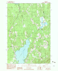
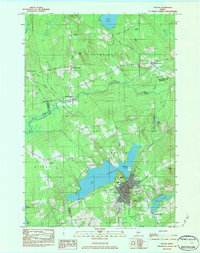
 1982 Green Lake1982 Print · USGSHancock County’s lakelands are shown here in the early eighties, centered on the vacation community of Lucerne-In-Maine. Genealogists and researchers can trace family landmarks like Wilson Corner, Eastern Cem, and Our Lady of the Lake Chapel set against the granite heights of Eagle Bluff.2 unique versions available
 - 1982 Map of Snow Mountain
 1982 Snow Mountain1982 Print · USGSPenobscot and Waldo counties come alive in the early eighties as a mosaic of small-town corners and rural hills. Genealogists and local historians can trace family plots at Chapman Cem, locate the Newburgh Sch, or explore the site of the Abandoned Airfield.2 unique versions available
 - 1982 Map of Dixmont
 1982 Dixmont1982 Print · USGSPenobscot and Waldo counties appear here in the early eighties as a landscape of crossroads hamlets and family farmsteads. Genealogists can trace rural roots through scattered sites like Sawyer Cem and Mt Holly Cem, or locate the Mount Harris Lookout Tower.2 unique versions available
 - 1982 Map of Plymouth, 1983 Print
 1982 Plymouth1983 Print · USGSPenobscot County landscape in the early eighties shows a transition from lakeside settlements to high-elevation timber and training grounds. Genealogists can locate family landmarks like Palmer Cem or the Emmanuel Ch near the banks of Plymouth Pond.
 - 1982 Map of Newport, 1983 Print
 1982 Newport1983 Print · USGSThe rural landscape of Somerset and Penobscot counties is captured here in the early eighties, showing the towns of Newport and Pittsfield along the water. Genealogists can trace family locations at Dogtown, Miles Corner, and numerous rural Cem sites.2 unique versions available
 - 1982 Map of Unity Pond, 1983 Print
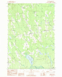
 1982 Unity Pond1983 Print · USGSThe rural crossroads of Waldo and Penobscot counties are captured here in the early eighties, just as conservation efforts like the Carlton Pond Waterfowl Production Area were established. Researchers can trace numerous family-named landmarks such as Gerrish Corner, Smarts Corner, and Troy Center.2 unique versions available
 - 1982 Map of West Corinth, 1983 Print
 1982 West Corinth1983 Print · USGSPenobscot County at the dawn of the eighties remains a landscape of quiet rural townships and family cemeteries. Genealogists can trace property roots near Exeter Mills, locate the Morrison Sch, or find ancestral plots at Corinthian Cem and Osgood Cem.2 unique versions available
 - 1982 Map of Carmel, 1983 Print
 1982 Carmel1983 Print · USGSPenobscot County's rural townships are shown here in the early eighties as the local landscape balanced small-town life with seasonal recreation. Genealogists and local historians can locate family plots at Highland Cem, trace the settlement at Damascus, or find old landmarks like Ring Hill Airport.2 unique versions available
 - 1982 Map of Corinna, 1983 Print
 1982 Corinna1983 Print · USGSCorinna and its surrounding crossroads settlements are captured here in the early eighties as the town’s industrial and river landscape remained firmly established. Researchers can trace family-named locales like Lyford Corner, Lincoln Mills, and Nutter Corner along the Sebasticook River.
 - 1982 Map of East Dixmont, 1983 Print
 1982 East Dixmont1983 Print · USGSPenobscot and Waldo counties meet in this early 1980s look at rural Maine as it transitioned between traditional farming and modern infrastructure. Genealogists can locate over a dozen family burial grounds including Bean Cem and Lufkin Cem, while tracing old routes like North Road.2 unique versions available
 - 1982 Map of Stetson, 1983 Print
 1982 Stetson1983 Print · USGSPenobscot County in the early eighties was a landscape of small mill sites and quiet rural crossroads. Researchers can find long-standing family landmarks like Crowell Cem, the community center of Stetson, and local industry at French Mill.
 - 1983 Map of South Lagrange, 1984 Print
 1983 South Lagrange1984 Print · USGSPenobscot County in the early eighties shows a landscape of interior wetlands and rail history. Trace the Bangor and Aroostook Railroad Grade and find local landmarks like South Lagrange, Gerry, and Christian Spring.
 - 1983 Map of Milo South, 1984 Print
 1983 Milo South1984 Print · USGSSouthern Piscataquis County in the early 1980s reveals a landscape of railroad junctions and river valleys. Genealogists and local historians can trace the B & A line through Derby or locate ancestral sites like Orneville Cem and Storers Corner.
 - 1983 Map of Garland, 1984 Print
 1983 Garland1984 Print · USGSPenobscot and Piscataquis counties are shown in the early 1980s, revealing a landscape of historic mill sites and family-named crossroads. Genealogists and local historians can trace residents through Evergreen Cem and old settlements like Dover South Mills or Silvers Mills.2 unique versions available
 - 1983 Map of Charleston, 1984 Print
 1983 Charleston1984 Print · USGSThe rural highlands of Penobscot County are captured here in the early eighties, showcasing institutional landmarks and small-town hubs. Local historians can trace the grounds of Higgins Classical Institute, locate Rollins Mill, or follow the path of Stage Coach Road.2 unique versions available
 - 1983 Map of Lagrange, 1984 Print
 1983 Lagrange1984 Print · USGSPenobscot County in the early eighties shows a landscape of timberlands and stream networks centered on the village of Lagrange. Trace the path of the Bangor and Aroostook railroad as it passes Paddy Hill and crosses Cold Stream.
 - 1983 Map of Bradford, 1984 Print
 1983 Bradford1984 Print · USGSPenobscot County in the early 1980s reveals a quiet landscape of rural Maine townships and interconnected waterways. Researchers can trace family history through numerous burial sites like Hillside Cem and Pond Cem, or locate landmarks such as Huntington Mill.2 unique versions available
 - 1984 Map of Dexter
 1984 Dexter1984 Print · USGSMaine's interior highlands near the Penobscot and Piscataquis county lines are shown here as they appeared in the early 1980s. Genealogists and local historians can trace family locations near Jackman Corner, the Storer Cem, or the namesake Spooners Mill.2 unique versions available
 - 1985 Map of Oakfield
 1985 Oakfield1985 Print · USGSAroostook County in the 1980s displays a balance between the timber-and-rail industry and the protected wilderness of the North Woods. Genealogists and local historians can trace family-named hubs like Smyrna Mills, Island Falls, and Knowles Corner along the Bangor and Aroostook railroad line.
 - 1985 Map of Bangor
 1985 Bangor1985 Print · USGSMid-Maine during the mid-eighties centers on the industrial pulse of the Penobscot River and its critical rail connections. Genealogists and historians can trace the development of river towns from Old Town to Ellsworth and locate regional landmarks like Fort Knox State Park.
 - 1985 Map of Millinocket Lake East, 1986 Print
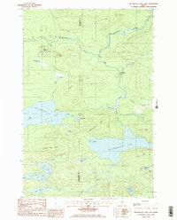 1985 Millinocket Lake East1986 Print · USGSThe Maine woods near the Penobscot and Piscataquis county lines are shown here in the mid-eighties as a landscape of timber management and remote waterways. Researchers can locate specific sites of activity like the Isthmus Logging Camp, Moosehorn Crossing, and Libby Camp among the many ponds and ridges.2 unique versions available
Showing maps 1-25 of 101
Top cities of Penobscot County
- Bangor historical maps
- Orono historical maps
- Brewer historical maps
- Hampden historical maps
- Old Town historical maps
- Hermon historical maps
See more
Frequently asked questions
- What are the different types of historical maps available for Penobscot County?
- What is the oldest map of Penobscot County?
- Where can I purchase historical maps of Penobscot County for my home or office?
- Where can I download high-res historical maps of Penobscot County?
- Are there historical topographic maps available for Penobscot County?
- Is there historical aerial imagery available for Penobscot County?
- Where are historical maps of Penobscot County sourced from?