1930s Maps of Somerset County, Maine
Explore 15 historic maps of Somerset County from the 1930s. These maps offer a rare glimpse into what life looked like during the 1930s — showing old roads, neighborhoods, homes, and landmarks that have changed or disappeared over time.
Whether you're researching your family's past, planning a metal detecting trip, or studying how Somerset County's landscape evolved across the 1930s, these high-resolution maps are a powerful tool for exploring the history of this region.
- Focus on a specific era: All maps on this page are from the 1930s, giving you a focused view of this time period.
- See what’s changed: Compare century-old streets, trails, and buildings to today's modern landscape using overlays and satellite layers.
- Research with precision: Use these maps for genealogy, historical research, land use analysis, or educational projects.
- View, download, or print: Maps are fully viewable online in high resolution, and can be downloaded or printed for your own records.
Start exploring Somerset County's history through authentic maps from the 1930s. This is your window into the past.
Somerset County, ME maps
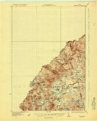
(15)- 1930 Map of Moosehead Lake
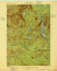
 1930 Moosehead Lake1930 Print · USGSMoosehead Lake in the early twentieth century was a landscape of remote rail junctions and lakeside settlements. Trace the old routes of the Maine Central Railroad to Rockwood or locate the Masterman School near the shores of North Bay.
 - 1930 Map of Pittsfield
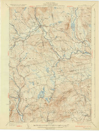
 1930 Pittsfield1930 Print · USGSSomerset County in the early thirties reveals a network of farming hamlets and lakeside communities connected by rail and river. Genealogists can trace family names through landmarks like Todds Corner West Ripley PO, Nutter Cemetery, and Town Farm Sch.
 - 1930 Map of Sandy Bay
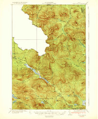
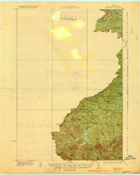 1930 Sandy Bay1930 Print · USGSUpper Somerset County at the Canadian border comes into focus in this late-1920s survey. Researchers can trace isolated wilderness outposts like Hilton Farm or follow the South Branch Penobscot River past South Branch Camp.5 unique versions available
 - 1930 Map of Kingfield
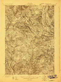 1930 Kingfield1930 Print · USGSThe Kingfield region and the western Maine highlands are captured here in the early 1930s. Genealogists can locate family homesteads near numerous district schools like Guild Sch and Hardy Sch, or trace the old roads through New Vineyard and Strong.4 unique versions available
 - 1931 Map of Dead River
 1931 Dead River1931 Print · USGSSomerset and Franklin counties in the mid-1920s show a landscape of remote plantations and traditional woodsman outposts. Genealogists and historians can trace localized landmarks like the Dead River School, the East Carry (Carry Pond PO) Pond, and Joe Farm.
 - 1931 Map of Skinner
 1931 Skinner1931 Print · USGSThe Maine-Quebec borderlands in the late 1920s reveal a landscape of remote rail outposts and logging woods. Trace the path of the Canadian Pacific through Lowelltown, find Hogans Camp, and explore the headwaters of the Moose River.3 unique versions available
 - 1932 Map of Stratton
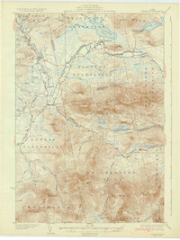 1932 Stratton1932 Print · USGSThe northern Maine woods in the late twenties and early thirties are captured here during a time of river-driven logging and remote plantation life. Local historians can trace the foundations of Eustis, the original layout of Flagstaff Pond, and rural schoolhouses like Browns Sch.3 unique versions available
 - 1932 Map of Spencer
 1932 Spencer1932 Print · USGSSomerset County’s wilderness is detailed here in the late twenties, showing a landscape defined by logging camps and remote sporting outposts. Researchers can trace the footprint of the Augusta Lumber Co Camp or locate the Spencer Lake Camps Gerard P O and Kibby Kamp.4 unique versions available
 - 1932 Map of Kingfield
 1932 Kingfield1932 Print · USGSThe western Maine mountains in the early thirties are defined here by narrow-gauge rail lines and a network of river-valley settlements. Genealogists can locate numerous rural schools and family landmarks like Soule Mill, Starbird Sch, and Dyer Hill.3 unique versions available
 - 1932 Map of Pittsfield
 1932 Pittsfield1932 Print · USGSMaine's Sebasticook Valley thrived in the early 1930s as a hub of rail transport and rural commerce. Genealogists and historians can trace the many family-named schoolhouses and crossroads, from Lincoln Mills and Dixie Corner to the Wing Cemetery.3 unique versions available
 - 1932 Map of Chain Lakes, 1961 Print
 1932 Chain Lakes1961 Print · USGSThe Maine-Quebec borderlands remained a land of remote sporting camps and timber tracts in the early 1930s. Researchers can locate vanished wilderness outposts like Chain Lakes Camp, the historic path of the Arnold Trail, and the Snow Mtn Fire Tower.2 unique versions available
 - 1933 Map of Pittsfield
 1933 Pittsfield1933 Print · USGSSomerset County in the early 1930s is a landscape of river-driven towns and remote farm schools connected by the Maine Central rail lines. Genealogy researchers can trace family landmarks like Goodwin Corner, the Wing Cemetery, and over a dozen schoolhouses including Merrill Sch.2 unique versions available
 - 1933 Map of Guilford, 1958 Print
 1933 Guilford1958 Print · USGSPiscataquis County townships thrive along the river and rail lines of central Maine in the early thirties. Local historians can trace the foundations of Guilford, locate rural landmarks like Spooners Mill, and find family heritage at Storer Cem or Abbot Village Sta.5 unique versions available
 - 1935 Map of Chain Lakes
 1935 Chain Lakes1935 Print · USGSThe Maine-Quebec borderlands are captured here in the mid-1930s, showing a remote wilderness of mountain ridges and narrow waterways. Researchers can trace the historic Arnold Trail and locate isolated outposts like Chain Lakes Camp and Moose Mill Camp.4 unique versions available
 - 1937 Map of Guilford
 1937 Guilford1937 Print · USGSPiscataquis County industry and rural life are captured here in the mid-1930s as the river-and-rail economy thrived. Genealogists can trace family roots through numerous local schoolhouses and landmarks like Spooners Mill, Lows Bridge, and the Wassookeag Cem.2 unique versions available
End of results
Showing maps 1-15 of 15
Top cities of Somerset County
- Fairfield historical maps
- Skowhegan historical maps
- Madison historical maps
- Pittsfield historical maps
- Norridgewock historical maps
- Anson historical maps
See more
Frequently asked questions
- What are the different types of historical maps available for Somerset County?
- What is the oldest map of Somerset County?
- Where can I purchase historical maps of Somerset County for my home or office?
- Where can I download high-res historical maps of Somerset County?
- Are there historical topographic maps available for Somerset County?
- Is there historical aerial imagery available for Somerset County?
- Where are historical maps of Somerset County sourced from?