1980s Maps of Somerset County, Maine
Explore 140 historic maps of Somerset County from the 1980s. These maps offer a rare glimpse into what life looked like during the 1980s — showing old roads, neighborhoods, homes, and landmarks that have changed or disappeared over time.
Whether you're researching your family's past, planning a metal detecting trip, or studying how Somerset County's landscape evolved across the 1980s, these high-resolution maps are a powerful tool for exploring the history of this region.
- Focus on a specific era: All maps on this page are from the 1980s, giving you a focused view of this time period.
- See what’s changed: Compare century-old streets, trails, and buildings to today's modern landscape using overlays and satellite layers.
- Research with precision: Use these maps for genealogy, historical research, land use analysis, or educational projects.
- View, download, or print: Maps are fully viewable online in high resolution, and can be downloaded or printed for your own records.
Start exploring Somerset County's history through authentic maps from the 1980s. This is your window into the past.
Somerset County, ME maps
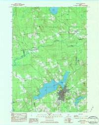
- 1982 Map of Norridgewock
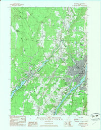
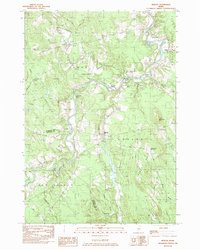
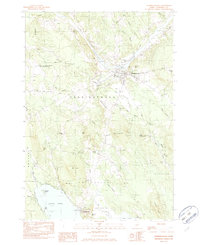 1982 Norridgewock1982 Print · USGSSomerset County's riverfront and upland terrain are documented here in the early eighties, capturing the area's development and natural hydrology. Genealogists and local historians can locate family landmarks like Ross Hill, rural cemeteries such as Gould Cem, and former school sites including Central Sch.2 unique versions available
 - 1982 Map of Clinton
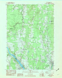 1982 Clinton1982 Print · USGSKennebec County river valleys and rural uplands are captured here in the early eighties. Genealogists and local historians can trace family-named sites such as Nobles Ferry Cem, Morrison Corner, and the Maine Central rail line.2 unique versions available
 - 1982 Map of Rome
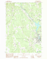
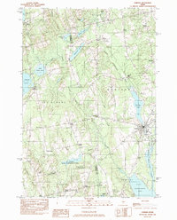
 1982 Rome1982 Print · USGSThe Belgrade Lakes region comes into focus during the early eighties, showcasing a complex network of waterways and lakeside settlements. Trace historical land markers and rail lines like the Stone Town Bdry Mon and the Maine Central near North Belgrade.
 - 1982 Map of Hinckley
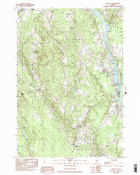 1982 Hinckley1982 Print · USGSThe Kennebec River corridor comes into focus in the early 1980s as it winds past the hills of Somerset and Kennebec counties. Genealogists and local historians can trace family burial sites like Tozier Cem and landmarks such as the Hinckley Home Farm Sch.
 - 1982 Map of Burnham, 1983 Print
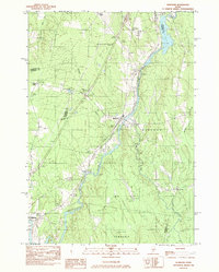 1982 Burnham1983 Print · USGSWaldo and Somerset counties come into focus in the early 1980s, centered on the river-and-rail corridor of the Sebasticook River. Researchers can trace old property lines and rural life near Burnham, Nash Corner, and the Maine Central RR line.
 - 1982 Map of Waterville, 1983 Print
 1982 Waterville1983 Print · USGSWaterville and Winslow thrived as industrial and academic centers during the early eighties, centered on the powerful Kennebec River. Genealogists and historians can trace the campuses of Colby College and Thomas College or locate family plots in Lakeview Cem and Drummond Cem.3 unique versions available
 - 1982 Map of Pittsfield, 1983 Print
 1982 Pittsfield1983 Print · USGSCentral Maine in the early eighties shows a landscape defined by the Sebasticook River and the Maine Central railroad. Genealogists can trace family names through local landmarks like Manson Corner and Fuller Corner Cem.
 - 1982 Map of Hartland, 1983 Print
 1982 Hartland1983 Print · USGSIn the early eighties, this Somerset County landscape was a tapestry of riverfront villages and wooded heights. Genealogists and local historians can trace family-named sites like Wing Cem or the Courser Memorial Sch near the shores of Indian Pond.
 - 1982 Map of Belgrade Lakes, 1983 Print
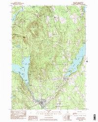
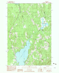
 1982 Belgrade Lakes1983 Print · USGSBelgrade Lakes and its surrounding chain of ponds are captured here in the early 1980s, showcasing a landscape defined by seasonal residency and rugged hills. Researchers can trace local landmarks like Mount Vernon Airport, the Vienna Ch, and the shoreline of Great Belgrade Pond.3 unique versions available
 - 1982 Map of Mercer, 1983 Print
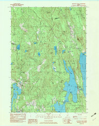
 1982 Mercer1983 Print · USGSSomerset County's rural river valleys are shown in detail during the late twentieth century as traditional crossroads communities remained the focus of local life. Researchers can locate family burial sites like Hampshire Hill Cem or trace the early footprint of Beech Hill Airport and Starks Ch.
 - 1982 Map of Newport, 1983 Print
 1982 Newport1983 Print · USGSThe rural landscape of Somerset and Penobscot counties is captured here in the early eighties, showing the towns of Newport and Pittsfield along the water. Genealogists can trace family locations at Dogtown, Miles Corner, and numerous rural Cem sites.2 unique versions available
 - 1982 Map of Unity Pond, 1983 Print
 1982 Unity Pond1983 Print · USGSThe rural crossroads of Waldo and Penobscot counties are captured here in the early eighties, just as conservation efforts like the Carlton Pond Waterfowl Production Area were established. Researchers can trace numerous family-named landmarks such as Gerrish Corner, Smarts Corner, and Troy Center.2 unique versions available
 - 1982 Map of Corinna, 1983 Print
 1982 Corinna1983 Print · USGSCorinna and its surrounding crossroads settlements are captured here in the early eighties as the town’s industrial and river landscape remained firmly established. Researchers can trace family-named locales like Lyford Corner, Lincoln Mills, and Nutter Corner along the Sebasticook River.
 - 1982 Map of Fairfield, 1983 Print
 1982 Fairfield1983 Print · USGSKennebec County river towns thrive along the banks of the Kennebec River during the early eighties. Researchers can trace family roots through numerous burial grounds like Reed Cem and Holt Cem, or locate historic school sites such as the Boston Ave Sch.2 unique versions available
 - 1984 Map of Cambridge
 1984 Cambridge1984 Print · USGSMaine's interior border between Somerset and Piscataquis counties is captured here in the early 1980s, showcasing a landscape of timber and small-town resilience. Genealogy researchers can trace local family lineages through Mt Pleasant Cem and Tyler Cem, or locate old homesteads near Pingree Center and Cambridge.
 - 1984 Map of Dexter
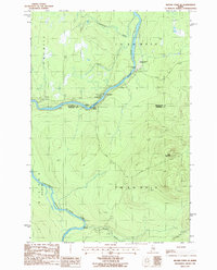
 1984 Dexter1984 Print · USGSMaine's interior highlands near the Penobscot and Piscataquis county lines are shown here as they appeared in the early 1980s. Genealogists and local historians can trace family locations near Jackman Corner, the Storer Cem, or the namesake Spooners Mill.2 unique versions available
 - 1985 Map of Moosehead Lake, 1986 Print
 1985 Moosehead Lake1986 Print · USGSThe Maine North Woods in the 1980s remain a landscape of vast timberlands, railroads, and the sprawling waters of the state's largest lake. Researchers can trace the Canadian Pacific line through Rockwood or locate historical townships from Seboomook to Kokadjo.
 - 1985 Map of Skowhegan, 1986 Print
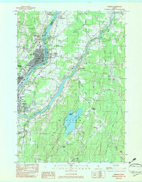
 1985 Skowhegan1986 Print · USGSCentral Maine in the mid-eighties shows a landscape of river-driven industry and rural crossroads. Genealogists can trace family names and farmsteads near Lake George or along the Maine Central Railroad through Pittsfield and Burnham.2 unique versions available
 - 1986 Map of Flagstaff Lake
 1986 Flagstaff Lake1986 Print · USGSThe Maine North Woods and the Dead River valley are captured here in the mid-1980s, an era of established hydroelectric lakes and outdoor recreation. Genealogists and researchers can trace the vicinity of Kennebago Settlement, Langtown Mill, and the villages of Stratton and Eustis.
 - 1986 Map of Megantic
 1986 Megantic1986 Print · USGSSettlement and industry along the international border define this mid-1980s survey of the Maine north woods. Genealogists and historians can trace the Canadian Pacific rail line through Jackman Station, Lowelltown, and the Jackman Mill.
 - 1986 Map of Beaver Pond SE
 1986 Beaver Pond SE1986 Print · USGSThe northern Maine wilderness of the 1980s is captured here, centered on the confluence of the St John River and its Southwest Branch. Researchers can trace the era's timber and transit network through the Red Pine Grove Landing Strip and remote outposts like Knowles Campsite.
 - 1986 Map of Dover-Foxcroft
 1986 Dover-Foxcroft1986 Print · USGSPiscataquis County at the edge of the great Maine woods is documented here in the mid-1980s, centered on the river-and-rail hubs of the interior. Trace the industrial footprints of Dover South Mills, the rail yards at Brownville Junction, or the historic Katahdin Iron Works.
 - 1986 Map of Rumford
 1986 Rumford1986 Print · USGSWestern Maine in the mid-eighties shows a rugged landscape of industrial river towns and high-country timber plantations. Trace the rail-and-river economy through Rumford, Dixfield, and the Maine Central RR or locate the historic campus of Farmington State College.
 - 1986 Map of Chamberlain Lake
 1986 Chamberlain Lake1986 Print · USGSThe Maine North Woods in the mid-eighties appear here as a land of protected wilderness and logging heritage, centered on the Allagash Wilderness Waterway. Researchers can trace the historic Tramway at Chamberlain Lake and locate old outposts like Churchill Depot.
 - 1986 Map of Eastman Brook
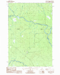 1986 Eastman Brook1986 Print · USGSThe remote Maine timberlands meet at the junction of the Northwest Branch River and Southwest Branch St John River in the mid-1980s. Researchers can trace the boundary of Aroostook and Somerset Counties through a landscape marked by Eastman Brook and isolated Gravel Pits.
Showing maps 1-25
Top cities of Somerset County
- Fairfield historical maps
- Skowhegan historical maps
- Madison historical maps
- Pittsfield historical maps
- Norridgewock historical maps
- Anson historical maps
See more
Frequently asked questions
- What are the different types of historical maps available for Somerset County?
- What is the oldest map of Somerset County?
- Where can I purchase historical maps of Somerset County for my home or office?
- Where can I download high-res historical maps of Somerset County?
- Are there historical topographic maps available for Somerset County?
- Is there historical aerial imagery available for Somerset County?
- Where are historical maps of Somerset County sourced from?