Old Maps of Somerset County, Maine for Hiking & Exploration
Hike through history with 897 historic maps of Somerset County. Explore old trails, ghost towns, and forgotten backroads — perfect for outdoor adventurers and local explorers.
- Rediscover forgotten places: Map out old mining camps, roads, and footpaths that no longer exist on modern maps.
- Layer with modern tools: Combine with LiDAR or satellite views to plan hikes through historical terrain.
- Made for exploration: Popular among hikers, overlanders, and local history lovers.
Use these maps to find adventure and explore the hidden past of Somerset County.
Somerset County, ME maps
(897)- 1892 Map of Waterville
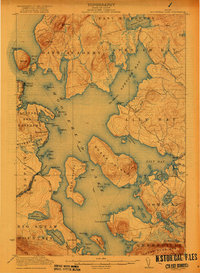
 1892 Waterville1892 Print · USGSCentral Maine thrived along the river valleys during the late nineteenth-century rail boom. Researchers can trace the development of the Maine Central Railroad through Waterville or locate older river crossings like Pishon Ferry.7 unique versions available
 - 1894 Map of Norridgewock
 1894 Norridgewock1894 Print · USGSSomerset and Kennebec counties are shown at the height of the Victorian era, characterized by an intricate network of glacial lakes and river ferries. Genealogists can trace early homesteads and transport points like Davis Ferry, Belgrade Mills, and South Norridgewock.
 - 1898 Map of Norridgewock
 1898 Norridgewock1898 Print · USGSSomerset and Kennebec Counties are shown here during the late Victorian era as the river-and-rail economy thrived. Genealogists can trace family holdings and old crossings like Davis Ferry, Belgrade Mills, and the historic village of Norridgewock.5 unique versions available
 - 1903 Map of Bingham, 1957 Print
 1903 Bingham1957 Print · USGSSomerset County’s river valleys and timberlands are captured here at the turn of the century, centered on the growing village of Bingham. Genealogists and historians can trace early settlements and wilderness landmarks from Caratunk to the shores of Pleasant Pond and Austin Stream.
 - 1904 Map of Anson
 1904 Anson1904 Print · USGSSomerset County is shown in the early 1900s as a thriving corridor of river industry and rail transport. Genealogists can trace family landmarks like Savage Hill or locate early centers such as Twelve Corners, North Anson, and the island-studded Kennebec River.4 unique versions available
 - 1905 Map of Bingham
 1905 Bingham1905 Print · USGSSomerset County's river-driven economy and rugged highlands are captured here in the early 1900s. Researchers can trace the Carrying Place portage route and locate early homesteads near Bingham, Merrill Pond, and Pierce Hill.5 unique versions available
 - 1905 Map of The Forks, 1954 Print
 1905 The Forks1954 Print · USGSThe Forks region of Somerset County was a wild landscape of timber tracts and river junctions at the turn of the century. You can trace the early logging routes along the Tote Road and locate remote landmarks like Squirt Gun Dam and the 10000 Acre Tract.
 - 1907 Map of The Forks
 1907 The Forks1907 Print · USGSSomerset County's logging heartland is captured at a pivotal moment as the Somerset R. R. pushed north toward the boundary. Local historians can trace early timber camps and river infrastructure like Squirtgun Dam and the Tote Road near The Forks.4 unique versions available
 - 1913 Map of Skowhegan
 1913 Skowhegan1913 Print · USGSSomerset County thrives as a hub of rail and river industry in this pre-war survey. Genealogists can trace family names through dozens of rural landmarks like Malbons Mills, the Union Church, and neighborhood schoolhouses from Athens to Canaan.4 unique versions available
 - 1920 Map of Moosehead Lake, 1955 Print
 1920 Moosehead Lake1955 Print · USGSMoosehead Lake in the early twentieth century was a hub of rail travel and island settlements accessible primarily by water. You can trace the historic Steamboat Route between Kineo Station, the Masterman School, and the remote outpost of Capens.
 - 1921 Map of Brassua Lake
 1921 Brassua Lake1921 Print · USGSThe North Maine Woods come alive in the 1920s at the intersection of the Canadian Pacific and Maine Central railroads. Genealogists and historians can trace logging-era life at Somerset Junction, Blaine School, and numerous seasonal sites like Depot Camp.3 unique versions available
 - 1922 Map of Moosehead Lake
 1922 Moosehead Lake1922 Print · USGSPiscataquis County’s wilderness is caught in a moment of transition during the early twenties as railroads and steamers opened the north woods. Researchers can trace the rails to Kineo Station or locate remote outposts like Masterman School and Capens.7 unique versions available
 - 1922 Map of Long Pond, 1955 Print
 1922 Long Pond1955 Print · USGSThe Maine north woods in the early twenties reveals a landscape defined by the Canadian Pacific rail line and the timber industry. Genealogists and historians can trace family-named sites like Fogg Farm, Mackamp, and Jackman Mill.5 unique versions available
 - 1923 Map of Brassua Lake
 1923 Brassua Lake1923 Print · USGSRailroads and river routes intersect in the Maine north woods at the start of the 1920s. Genealogists and historians can trace the junction of the Canadian Pacific at Somerset Junction Tarratine PO and locate remote outposts like Blaine School and Cornish Farm.4 unique versions available
 - 1923 Map of Attean, 1965 Print
 1923 Attean1965 Print · USGSSomerset County's wilderness is captured here in the 1920s, showcasing a network of remote outposts and waterways along the international border. Genealogists and historians can trace the Canadian Pacific line to Jackman Station, Boston Ranch, and the Stetson School.2 unique versions available
 - 1924 Map of Farmington
 1924 Farmington1924 Print · USGSFranklin County in the early 1920s is a landscape of river-powered mills and intersecting rail lines, including the Sandy River and Rangeley Lakes RR. Genealogists can locate dozens of country schools and rural settlements like Allens Mills and Knowltons Corner.6 unique versions available
 - 1924 Map of Long Pond
 1924 Long Pond1924 Print · USGSSomerset County’s timber and rail landscape is captured here in the early twenties as the logging and sporting industries thrived. Trace the Canadian Pacific rail line through Jackman Station to remote outposts like Mackamp and the Whipple Farm.5 unique versions available
 - 1925 Map of Pierce Pond
 1925 Pierce Pond1925 Print · USGSSomerset County in the mid-twenties was a landscape of remote timberlands and sporting camps connected by river landings. Genealogists and historians can trace early wilderness outposts like Grace Pond Camp and industrial markers like Spencer Dam or the Coburn Mtn Lookout Station.2 unique versions available
 - 1925 Map of Attean
 1925 Attean1925 Print · USGSThe Maine wilderness at the Canadian border in the mid-1920s is a landscape of timber and rail. Researchers can trace the development of Jackman and Jackman Station or locate remote sites like Boston Ranch and Stetson School.6 unique versions available
 - 1926 Map of Burnham
 1926 Burnham1926 Print · USGSWaldo and Kennebec counties in the mid-1920s are captured here as a landscape of rural schoolhouses and family-named corners centered on the Sebasticook River. Genealogists can trace family roots through landmarks like Quaker Hill Church, the Freedom Town House, and dozens of district sites like Beech Hill School.3 unique versions available
 - 1927 Map of Sandy Bay
 1927 Sandy Bay1927 Print · USGSThe Maine-Quebec borderlands appear here in the late twenties, showing the high-country landscape of Somerset County. Genealogists and researchers can locate remote outposts like Hilton Farm and landmarks such as Little Canada Falls and Isaac Kelly Notch.5 unique versions available
 - 1927 Map of Pierce Pond
 1927 Pierce Pond1927 Print · USGSThe remote Maine woods of Somerset County come alive in this mid-1920s survey of the Upper and Lower Enchanted territories. Genealogists and historians can trace early wilderness outposts like Salmon Streams Farm, West Forks, and the riverside Hayden Landing.6 unique versions available
 - 1928 Map of Chain Lakes
 1928 Chain Lakes1928 Print · USGSThe Maine North Woods and the Canadian border come alive in the late 1920s, showing a landscape defined by timber camps and mountain peaks. Genealogists and historians can trace old forest outposts like Moosehill Camp and Ben Dewitt Camp or the location of Round Mtn PO.
 - 1928 Map of Skinner
 1928 Skinner1928 Print · USGSThe northern Maine woods meet the Canadian border in the late 1920s, dominated by the Canadian Pacific Railway and the Moose River headwaters. Trace the rail-side outposts of Skinner and Summit Camps or the remote waters of Beattie Pond.4 unique versions available
 - 1928 Map of Spencer
 1928 Spencer1928 Print · USGSNorthern Maine's remote logging and sporting country is captured here during the late 1920s. You can trace early wilderness outposts like Gerard (PO) Spencer Lake Camps and Kibby Kamp near Spencer Lake.2 unique versions available
Showing maps 1-25 of 897
Top cities of Somerset County
- Fairfield historical maps
- Skowhegan historical maps
- Madison historical maps
- Pittsfield historical maps
- Norridgewock historical maps
- Anson historical maps
See more
Frequently asked questions
- What are the different types of historical maps available for Somerset County?
- What is the oldest map of Somerset County?
- Where can I purchase historical maps of Somerset County for my home or office?
- Where can I download high-res historical maps of Somerset County?
- Are there historical topographic maps available for Somerset County?
- Is there historical aerial imagery available for Somerset County?
- Where are historical maps of Somerset County sourced from?