1990s Maps of Somerset County, Maine
Explore 15 historic maps of Somerset County from the 1990s. These maps offer a rare glimpse into what life looked like during the 1990s — showing old roads, neighborhoods, homes, and landmarks that have changed or disappeared over time.
Whether you're researching your family's past, planning a metal detecting trip, or studying how Somerset County's landscape evolved across the 1990s, these high-resolution maps are a powerful tool for exploring the history of this region.
- Focus on a specific era: All maps on this page are from the 1990s, giving you a focused view of this time period.
- See what’s changed: Compare century-old streets, trails, and buildings to today's modern landscape using overlays and satellite layers.
- Research with precision: Use these maps for genealogy, historical research, land use analysis, or educational projects.
- View, download, or print: Maps are fully viewable online in high resolution, and can be downloaded or printed for your own records.
Start exploring Somerset County's history through authentic maps from the 1990s. This is your window into the past.
Somerset County, ME maps
(15)- 1993 Map of Lac Etchemin
 1993 Lac Etchemin1993 Print · USGSThe borderlands of Maine and Quebec in the 1990s are defined here by the international boundary cutting through dense timberlands and the Beauce valley. Researchers can trace the Port of Entry near the Saint John River Southwest Branch and explore the layouts of Beauceville and Lac-Etchemin.
 - 1993 Map of Clayton Lake, 1994 Print
 1993 Clayton Lake1994 Print · USGSThe North Woods along the Maine and Quebec border remained a vast wilderness of timber and water in the early nineties. Researchers can trace historic river crossings and remote outposts like Ninemile Bridge, Saint-Pamphile, and the Harvey Farm.
 - 1993 Map of Montmagny, 1994 Print
 1993 Montmagny1994 Print · USGSThe international borderlands of Maine and Quebec come into focus during the early nineties, from the Saint Lawrence riverfront to the deep North Woods. Researchers can trace historic settlements like Montmagny or follow the remote heights of the Monts Notre-Dame toward Lac Frontière.
 - 1994 Map of Dover-Foxcroft
 1994 Dover-Foxcroft1994 Print · USGSCentral Maine in the mid-nineties shows a landscape of timber-driven towns and deep glacial lakes. Trace the paths of the Canadian Pacific RR or locate the Moscow Air Force Station Transmit Site and Sebec Lake.
 - 1994 Map of Rumford
 1994 Rumford1994 Print · USGSWestern Maine's mountains and glacial lakes are shown here in the mid-1990s, from the peaks of the Mahoosuc Range to the banks of the Androscoggin River. Trace the Maine Central RR through Dixfield or locate lakeside settlements like Oquossoc.
 - 1994 Map of Chamberlain Lake
 1994 Chamberlain Lake1994 Print · USGSThe North Maine Woods in the early nineties remained a network of logging outposts and protected waterways. You can trace the historic logging infrastructure at Churchill Depot, the portage at Tramway, and remote landings such as Telos Landing.
 - 1994 Map of Moosehead Lake
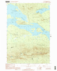
 1994 Moosehead Lake1994 Print · USGSThe Maine North Woods at the end of the twentieth century remains a landscape of vast timberlands and remote outposts. Researchers can trace the Appalachian National Scenic Trail and locate historic water controls like Chesuncook Dam and Ripogenus Dam.
 - 1994 Map of Megantic
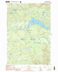
 1994 Megantic1994 Print · USGSUpper Somerset County during the early 1990s shows a landscape of remote timber outposts and the Canadian Pacific railroad. Genealogists and historians can trace the corridor through Jackman and Dennistown or locate old rail points like Skinner and Lowelltown.
 - 1994 Map of Flagstaff Lake
 1994 Flagstaff Lake1994 Print · USGSThe Maine wilderness and the Quebec border come alive in this mid-nineties survey of the Dead River country. Researchers can trace the Appalachian Trail over Bigelow Mountain and locate remote sites like Kennebago Settlement.
 - 1997 Map of Holeb, 1999 Print
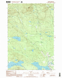
 1997 Holeb1999 Print · USGSSomerset County in the late nineties is a landscape of expansive timberlands and interconnected waterways. Researchers can trace the isolated settlement of Holeb, explore the bends of the Moose River, and locate family landmarks like Boston Ranch.
 - 1997 Map of Jackman, 1999 Print
 1997 Jackman1999 Print · USGSThe North Woods of Somerset County appear in the late nineties as a hub of rail and river activity. Researchers can trace the Canadian Pacific line through Jackman or locate remote sites like Foxs Camp and the Sky Lodge Landing Strip.
 - 1997 Map of Attean Pond, 1999 Print
 1997 Attean Pond1999 Print · USGSSomerset County’s northern woods and waterways appear here in the late twentieth century, centered on the village of Jackman. Local researchers can trace the portage and water routes between Attean Pond and Attean Landing or locate Holeb Falls on the river.
 - 1997 Map of Sugarloaf Mtn, 2000 Print
 1997 Sugarloaf Mtn2000 Print · USGSMaine’s High Peaks region in the late nineties is defined by the rise of mountain recreation and the winding path of the Appalachian National Scenic Trail. Trace the early development of Carrabassett Valley and the landmarks around Sugarloaf Mtn and Stratton.
 - 1997 Map of Stratton, 2000 Print
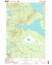
 1997 Stratton2000 Print · USGSThe northern Maine woods near the close of the century are defined here by the great expanse of Flagstaff Lake. Local historians can trace the settlement footprints of Stratton and Eustis or locate remote camps near Jim Pond and Cranberry Peak.
 - 1997 Map of The Horns, 2000 Print
 1997 The Horns2000 Print · USGSHigh peaks and deep waters define this corner of Somerset County in the late nineties. Hikers and historians can trace the Appalachian National Scenic Trail across The Horns and Avery Peak overlooking the expansive Flagstaff Lake.
End of results
Showing maps 1-15 of 15
Top cities of Somerset County
- Fairfield historical maps
- Skowhegan historical maps
- Madison historical maps
- Pittsfield historical maps
- Norridgewock historical maps
- Anson historical maps
See more
Frequently asked questions
- What are the different types of historical maps available for Somerset County?
- What is the oldest map of Somerset County?
- Where can I purchase historical maps of Somerset County for my home or office?
- Where can I download high-res historical maps of Somerset County?
- Are there historical topographic maps available for Somerset County?
- Is there historical aerial imagery available for Somerset County?
- Where are historical maps of Somerset County sourced from?