1900-1909 Maps of Worcester County, Maryland
Explore 5 historic maps of Worcester County from 1900-1909. These maps offer a rare glimpse into what life looked like during the 1900s — showing old roads, neighborhoods, homes, and landmarks that have changed or disappeared over time.
Whether you're researching your family's past, planning a metal detecting trip, or studying how Worcester County's landscape evolved across the 1900s, these high-resolution maps are a powerful tool for exploring the history of this region.
- Focus on a specific era: All maps on this page are from the 1900s, giving you a focused view of this time period.
- See what’s changed: Compare century-old streets, trails, and buildings to today's modern landscape using overlays and satellite layers.
- Research with precision: Use these maps for genealogy, historical research, land use analysis, or educational projects.
- View, download, or print: Maps are fully viewable online in high resolution, and can be downloaded or printed for your own records.
Start exploring Worcester County's history through authentic maps from the 1900s. This is your window into the past.
Worcester County, MD maps
(5)- 1901 Map of Snow Hill
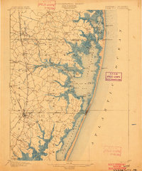
 1901 Snow Hill1901 Print · USGSSnow Hill and the surrounding Worcester County wetlands are captured at the opening of the twentieth century, when the Pocomoke River was a vital Steamboat Route. Researchers can trace the Waterman culture through historic sites like Public Landing and the railway hubs at Girdletree and Stockton.4 unique versions available
 - 1901 Map of Salisbury
 1901 Salisbury1901 Print · USGSWicomico County at the turn of the century centered on the steamboat and rail traffic through Salisbury. Trace historic family-named locations and rural infrastructure like Fooks School, Minksville, and the steam route at Shad Pt.4 unique versions available
 - 1901 Map of Green Run
 1901 Green Run1901 Print · USGSThe Maryland and Virginia coastline at the start of the century was a land of life-saving stations and isolated landings. Trace the maritime heritage of the barrier islands through North Beach L.S.S. and the commercial roots of Scotts Landing.4 unique versions available
 - 1901 Map of Ocean City
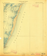
 1901 Ocean City1901 Print · USGSThe Maryland and Delaware coastlines were still largely defined by maritime labor and new rail lines at the turn of the century. You can trace the early streets of Ocean City and Berlin or locate landmarks like the Fenwick Island Lighthouse and Muskrattown.5 unique versions available
 - 1902 Map of Pittsville
 1902 Pittsville1902 Print · USGSEastern Shore life at the turn of the century is centered on the Baltimore Chesapeake and Atlantic rail line and the Pocomoke River. Genealogists can locate family-named sites like Tilghman Pond and Hearns or trace the old rail stop at Ironshire Station.4 unique versions available
End of results
Showing maps 1-5 of 5
Top cities of Worcester County
- Ocean Pines historical maps
- Ocean City historical maps
- West Ocean City historical maps
- Pocomoke City historical maps
- Berlin historical maps
- Snow Hill historical maps
Frequently asked questions
- What are the different types of historical maps available for Worcester County?
- What is the oldest map of Worcester County?
- Where can I purchase historical maps of Worcester County for my home or office?
- Where can I download high-res historical maps of Worcester County?
- Are there historical topographic maps available for Worcester County?
- Is there historical aerial imagery available for Worcester County?
- Where are historical maps of Worcester County sourced from?