1970s Maps of Worcester County, Maryland
Explore 2 historic maps of Worcester County from the 1970s. These maps offer a rare glimpse into what life looked like during the 1970s — showing old roads, neighborhoods, homes, and landmarks that have changed or disappeared over time.
Whether you're researching your family's past, planning a metal detecting trip, or studying how Worcester County's landscape evolved across the 1970s, these high-resolution maps are a powerful tool for exploring the history of this region.
- Focus on a specific era: All maps on this page are from the 1970s, giving you a focused view of this time period.
- See what’s changed: Compare century-old streets, trails, and buildings to today's modern landscape using overlays and satellite layers.
- Research with precision: Use these maps for genealogy, historical research, land use analysis, or educational projects.
- View, download, or print: Maps are fully viewable online in high resolution, and can be downloaded or printed for your own records.
Start exploring Worcester County's history through authentic maps from the 1970s. This is your window into the past.
Worcester County, MD maps
(2)- 1972 Map of Kingston, 1973 Print
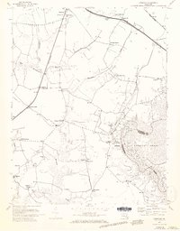 1972 Kingston1973 Print · USGSSomerset County in the early seventies shows a landscape of tidal creeks and deep-rooted rural communities. Genealogists can trace family footprints across numerous sites like Moores Chapel, Frogeye, and the crossroads at Pauls Corner.3 unique versions available
 - 1973 Map of Dividing Creek, 1975 Print
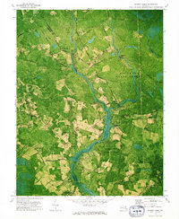 1973 Dividing Creek1975 Print · USGSThe borderlands of Worcester and Somerset counties remained a landscape of dense timber and quiet rural settlements in the early seventies. Genealogists and historians can trace family roots at Emanuel Cem or locate old community centers like Whiteburg and Friendship Ch.
End of results
Showing maps 1-2 of 2
Top cities of Worcester County
- Ocean Pines historical maps
- Ocean City historical maps
- West Ocean City historical maps
- Pocomoke City historical maps
- Berlin historical maps
- Snow Hill historical maps
Frequently asked questions
- What are the different types of historical maps available for Worcester County?
- What is the oldest map of Worcester County?
- Where can I purchase historical maps of Worcester County for my home or office?
- Where can I download high-res historical maps of Worcester County?
- Are there historical topographic maps available for Worcester County?
- Is there historical aerial imagery available for Worcester County?
- Where are historical maps of Worcester County sourced from?