1980s Maps of Worcester County, Maryland
Explore 8 historic maps of Worcester County from the 1980s. These maps offer a rare glimpse into what life looked like during the 1980s — showing old roads, neighborhoods, homes, and landmarks that have changed or disappeared over time.
Whether you're researching your family's past, planning a metal detecting trip, or studying how Worcester County's landscape evolved across the 1980s, these high-resolution maps are a powerful tool for exploring the history of this region.
- Focus on a specific era: All maps on this page are from the 1980s, giving you a focused view of this time period.
- See what’s changed: Compare century-old streets, trails, and buildings to today's modern landscape using overlays and satellite layers.
- Research with precision: Use these maps for genealogy, historical research, land use analysis, or educational projects.
- View, download, or print: Maps are fully viewable online in high resolution, and can be downloaded or printed for your own records.
Start exploring Worcester County's history through authentic maps from the 1980s. This is your window into the past.
Worcester County, MD maps
(8)- 1980 Map of Selbyville, 1982 Print
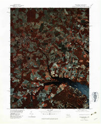 1980 Selbyville1982 Print · USGSThe Delaware-Maryland borderlands appear in striking infrared detail during the early 1980s, showing a landscape defined by traditional agriculture and winding waterways. Researchers can trace the rural layouts of Selbyville, Bishopville, and Roxana as they existed forty years ago.
 - 1980 Map of Assawoman Bay, 1982 Print
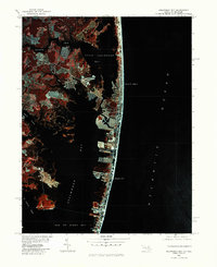 1980 Assawoman Bay1982 Print · USGSCoastal Maryland and Delaware are seen here in the early eighties as beachfront development reshaped the barrier islands. Trace the growth of Ocean City and Fenwick Island between the Atlantic Ocean and Assawoman Bay.
 - 1981 Map of Chincoteague, 1982 Print
 1981 Chincoteague1982 Print · USGSThe Delmarva Eastern Shore at the start of the eighties shows a unique blend of traditional coastal life and modern aerospace technology. Researchers can trace the Penn Central rail line through rural towns like Modest Town and Bloxom or explore the marshlands of the Saxis Marsh Waterfowl Management Area and Refuge.
 - 1982 Map of Wango, 1983 Print
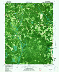 1982 Wango1983 Print · USGSWicomico County in the late 1970s is characterized by dense state forests and the intricate drainage of the Nassawango watershed. Genealogists can trace family landmarks like St Johns Ch and Friendship Ch or find old roads near Wango and Powellville.2 unique versions available
 - 1982 Map of Salisbury, 1983 Print
 1982 Salisbury1983 Print · USGSThe Lower Eastern Shore enters the early eighties with Salisbury at its heart, showing a mix of college-town growth and rural timberlands. Trace the local landscape from Salisbury State College to the quiet reaches of the Pocomoke State Forest.2 unique versions available
 - 1982 Map of Ninepin Branch, 1983 Print
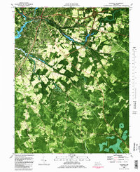
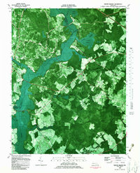 1982 Ninepin Branch1983 Print · USGSWorcester County remained a landscape of wetlands and small farming settlements in the early eighties. Researchers can trace the Conrail line to Ironshire Sta or locate rural landmarks like Mt Pleasant Ch and Adkins Pond.
 - 1983 Map of Salisbury, 1984 Print
 1983 Salisbury1984 Print · USGSThe Lower Eastern Shore was a landscape of tide and timber in the early eighties, from the bustling streets of Salisbury to the wild coast of Assateague Island. Researchers can trace the rail-and-road network of the Conrail and U S Highway 50 while locating historic centers like Princess Anne and Crisfield.
 - 1984 Map of Chincoteague
 1984 Chincoteague1984 Print · USGSThe Virginia Eastern Shore and Delmarva Peninsula are captured here in the mid-1980s, showcasing a landscape of barrier islands and tidewater towns. Researchers can trace the Penn Central rail line through Accomac or locate the Wallops Flight Facility (NASA) and Chincoteague Nat Wildlife Refuge.2 unique versions available
End of results
Showing maps 1-8 of 8
Top cities of Worcester County
- Ocean Pines historical maps
- Ocean City historical maps
- West Ocean City historical maps
- Pocomoke City historical maps
- Berlin historical maps
- Snow Hill historical maps
Frequently asked questions
- What are the different types of historical maps available for Worcester County?
- What is the oldest map of Worcester County?
- Where can I purchase historical maps of Worcester County for my home or office?
- Where can I download high-res historical maps of Worcester County?
- Are there historical topographic maps available for Worcester County?
- Is there historical aerial imagery available for Worcester County?
- Where are historical maps of Worcester County sourced from?