1900s (20th Century) Maps of Worcester County, Massachusetts
Explore 265 historic maps of Worcester County from the 1900s (20th Century). These maps offer a rare glimpse into what life looked like during the 1900s — showing old roads, neighborhoods, homes, and landmarks that have changed or disappeared over time.
Whether you're researching your family's past, planning a metal detecting trip, or studying how Worcester County's landscape evolved across the 1900s, these high-resolution maps are a powerful tool for exploring the history of this region.
- Focus on a specific era: All maps on this page are from the 1900s, giving you a focused view of this time period.
- See what’s changed: Compare century-old streets, trails, and buildings to today's modern landscape using overlays and satellite layers.
- Research with precision: Use these maps for genealogy, historical research, land use analysis, or educational projects.
- View, download, or print: Maps are fully viewable online in high resolution, and can be downloaded or printed for your own records.
Start exploring Worcester County's history through authentic maps from the 1900s. This is your window into the past.
Worcester County, MA maps
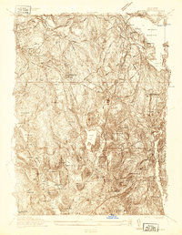
(265)- 1900 Map of Blackstone
 1900 Blackstone1900 Print · USGSThe Blackstone Valley was a bustling manufacturing corridor when this late Victorian-era survey was published. Genealogists and historians can trace the industrial mill villages along the Blackstone River, including Whitinsville, Manchaug, and Millville.7 unique versions available
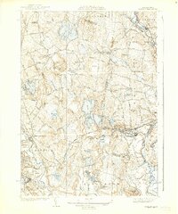
 - 1908 Map of Quinsigamond
 1908 Quinsigamond1908 Print · USGSCentral Massachusetts and its bordering states are seen here in the early twentieth century as industry and transit reshaped the Blackstone Valley. Genealogists and historians can trace the early footprints of Worcester, the expansion of the Wachusett Reservoir, and rail lines like the Boston and Albany Railroad.3 unique versions available
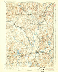
 - 1908 Map of Ware
 1908 Ware1908 Print · USGSCentral Massachusetts at the turn of the century reveals the Swift River Valley decades before the Quabbin Reservoir changed the landscape forever. Trace the lost footprints of Enfield and Dana, or follow the Central Vermont RR through Greenwich Village and Ware.2 unique versions available
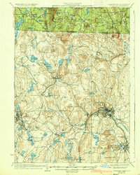
 - 1915 Map of Brookfield
 1915 Brookfield1915 Print · USGSCentral Massachusetts and the Connecticut border are captured in the final months of the pre-war era, showing a dense network of textile villages and rail lines. Genealogists and local historians can trace the growth of Southbridge or locate landmarks like the Electric Power Relay Station and Lead Mine Mountain.
 - 1918 Map of Framingham
 1918 Framingham1918 Print · USGSEastern Massachusetts is seen here as a bustling rail-and-river corridor during the early twentieth century. Genealogists and historians can trace old property lines and landmarks like the Wayside Inn, the State Prison, and Nine Acre Corner.2 unique versions available
 - 1919 Map of Franklin
 1919 Franklin1919 Print · USGSEastern Massachusetts at the end of the Great War was a landscape defined by its river-powered mill towns and expanding rail corridors. Genealogists and local historians can trace family roots through industrial hamlets like City Mills, Unionville, and Sheldonville.2 unique versions available
 - 1919 Map of Palmer
 1919 Palmer1919 Print · USGSHampden County and the Connecticut borderlands are captured here during the height of the steam-rail era. Genealogists and historians can trace the foundations of local industry at Fosketts Mill, the Granite Quarry, and the sprawling Monson State Hospital.
 - 1919 Map of Blackstone
 1919 Blackstone1919 Print · USGSThe Blackstone Valley at the end of the Great War was a dense network of industrial villages and crucial rail junctions. Genealogists and historians can trace the family-named landmarks of the era, from Saundersville and Linwood to the heights of Dorothy Hill.2 unique versions available
 - 1921 Map of Brookfield
 1921 Brookfield1921 Print · USGSMassachusetts and Connecticut borderlands appear here in the early twentieth century as a complex landscape of hill farms, industrial villages, and rail corridors. Genealogists can locate family landmarks like Foster Hill or trace the early industrial footprint of Leadmine and the Boston and Albany Railroad.
 - 1921 Map of Webster
 1921 Webster1921 Print · USGSThe industrial valleys and hill towns of southern Worcester County are seen here just after the Great War. Genealogists can trace the rail-centered growth of Webster and Auburn Sta. or locate old village centers like Cherry Valley and Rochdale.
 - 1921 Map of Franklin, 1942 Print
 1921 Franklin1942 Print · USGSThe Charles River valley was a network of bustling rail junctions and mill villages in the years following the Great War. You can trace the development of towns like Franklin and Medway or locate smaller centers such as City Mills and Unionville.
 - 1931 Map of Groton
 1931 Groton1931 Print · USGSThe Massachusetts and New Hampshire borderlands in the early thirties reveal a landscape of river-powered rail and rural industry. Genealogists can trace family landmarks and transport hubs like Hollis Sta, Potanopa Pond, and the Runnels Bridge.
 - 1931 Map of Fitchburg
 1931 Fitchburg1931 Print · USGSThe Massachusetts and New Hampshire border region was a network of mill villages and mountain ridges in the early thirties. Genealogists and historians can locate rural landmarks like School No 8, the High Bridge, and the Boston and Maine rail line.
 - 1932 Map of Warwick
 1932 Warwick1932 Print · USGSIn the early 1930s, the tri-state border region of Massachusetts, New Hampshire, and Vermont was a vital corridor of rail and river transit. Genealogists and researchers can trace the old rail lines of the Central Vermont Ry, locate the East Northfield Sta, or find family landmarks like Curtis Corners and Wheeler Fall.
 - 1932 Map of Winchendon
 1932 Winchendon1932 Print · USGSThe borderlands of New Hampshire and Massachusetts come into focus during the early thirties, showing a rural landscape dominated by glacial lakes and high ridges. Researchers can trace the Boston and Maine line through State Line or locate family sites at Rand Cem and Sch No 1.
 - 1934 Map of Worcester
 1934 Worcester1934 Print · USGSMid-depression Worcester and Holden emerge as a dense network of industrial ponds, institutions, and rail lines. Genealogists can trace family connections through the Grove Cem, numerous local schools like Chaffin Sch, and the neighborhoods around Union Sta.
 - 1935 Map of Ayer
 1935 Ayer1935 Print · USGSThe intersection of Middlesex and Worcester counties in the mid-1930s reveals a landscape of military bases, historic academies, and industrial ponds. Researchers can trace the layout of Fort Devens, the grounds of the Groton School, and the unique settlement at Shaker Village.
 - 1935 Map of Warwick
 1935 Warwick1935 Print · USGSUpper Massachusetts and the Tri-State borderlands thrive during the mid-thirties as rail corridors and river valleys connect mountain villages. Researchers can trace the Central Vermont Ry through Northfield or locate family landmarks like Barrows Cem and Barber Sch.2 unique versions available
 - 1935 Map of Groton
 1935 Groton1935 Print · USGSCrossing the New Hampshire border in the 1930s, this area was a bustling hub of rail transport and riverside industry. Researchers can trace the legacy of communal life at Shaker Village, locate the campus of Groton School, or follow the lines of the Boston and Maine RR through towns like Pepperell and Shirley.
 - 1935 Map of Fitchburg
 1935 Fitchburg1935 Print · USGSThe industrial corridor and border hills of north-central Massachusetts and southern New Hampshire are captured here in the mid-1930s. Trace the intricate rail networks of the Old Colony Railroad and find local landmarks like School No 8 or Rollstone Hill.3 unique versions available
 - 1935 Map of Millbury
 1935 Millbury1935 Print · USGSThe Worcester County countryside in the mid-1930s reveals a dense network of industrial hamlets and rail lines before the modern interstate era. Researchers can trace family roots at St Roche Cem or Bnai Brith Cem and locate vanished schoolhouses like the Hammond Sch.
 - 1935 Map of Shirley
 1935 Shirley1935 Print · USGSThe Nashua River valley during the mid-1930s shows a region defined by its rail connections and hilltop villages. Genealogists can trace family sites near Shirley Center, the Industrial School, and cemeteries like St Leo Cem.3 unique versions available
 - 1935 Map of Winchendon
 1935 Winchendon1935 Print · USGSIn the mid-1930s, the border between Massachusetts and New Hampshire was defined by busy rail corridors and small mill towns. Researchers can trace family-named sites and industrial infrastructure from Athol Center to Pequoig Station and the rural School No 1.4 unique versions available
 - 1936 Map of Groton
 1936 Groton1936 Print · USGSNorthern Middlesex County and southern New Hampshire appear here in the mid-1930s, showing a landscape shaped by river power and a dense rail network. Researchers can trace historic sites like the Shaker Village and Groton School, or locate old depots at Townsend Harbor and Ayer.3 unique versions available
 - 1936 Map of Fitchburg
 1936 Fitchburg1936 Print · USGSNorthwestern Massachusetts and southern New Hampshire are shown here during the mid-1930s, featuring a mature network of rail lines and industrial river towns. Genealogists can locate family landmarks like School No 9 or trace the early paths of the Fitchburg Railroad and Old Colony Railroad Fitchburg Branch.2 unique versions available
Showing maps 1-25 of 265
Top cities of Worcester County
- Worcester historical maps
- Leominster historical maps
- Fitchburg historical maps
- Shrewsbury historical maps
- Milford historical maps
- Gardner historical maps
See more
Frequently asked questions
- What are the different types of historical maps available for Worcester County?
- What is the oldest map of Worcester County?
- Where can I purchase historical maps of Worcester County for my home or office?
- Where can I download high-res historical maps of Worcester County?
- Are there historical topographic maps available for Worcester County?
- Is there historical aerial imagery available for Worcester County?
- Where are historical maps of Worcester County sourced from?