1890s Maps of Worcester County, Massachusetts
Explore 18 historic maps of Worcester County from the 1890s. These maps offer a rare glimpse into what life looked like during the 1890s — showing old roads, neighborhoods, homes, and landmarks that have changed or disappeared over time.
Whether you're researching your family's past, planning a metal detecting trip, or studying how Worcester County's landscape evolved across the 1890s, these high-resolution maps are a powerful tool for exploring the history of this region.
- Focus on a specific era: All maps on this page are from the 1890s, giving you a focused view of this time period.
- See what’s changed: Compare century-old streets, trails, and buildings to today's modern landscape using overlays and satellite layers.
- Research with precision: Use these maps for genealogy, historical research, land use analysis, or educational projects.
- View, download, or print: Maps are fully viewable online in high resolution, and can be downloaded or printed for your own records.
Start exploring Worcester County's history through authentic maps from the 1890s. This is your window into the past.
Worcester County, MA maps
(18)- 1890 Map of Belchertown
 1890 Belchertown1890 Print · USGSThe Swift River valley is seen here in the late nineteenth century, long before the creation of the Quabbin Reservoir. Genealogists and local historians can trace the vanished streets of Enfield, Greenwich, and North Dana, or follow the old Boston & Albany R. R. line.
 - 1890 Map of Brookfield
 1890 Brookfield1890 Print · USGSCentral Massachusetts and the Connecticut border lands are captured here in the late nineteenth century, showing a landscape defined by water power and rail. You can trace the Boston and Albany Railroad corridor and explore industrial pockets like Globe Village and the historic Leadmine site.
 - 1890 Map of Winchendon
 1890 Winchendon1890 Print · USGSThe Worcester County borderlands at the end of the 19th century reveal a complex landscape of mill villages and hilltop commons. Researchers can trace the early industrial footprint at Powers Mills, find the rail junction at Pequoig Station, and locate the ancestral centers of Royalston Center or Templeton Center.
 - 1892 Map of Webster
 1892 Webster1892 Print · USGSWorcester County mill towns and rail junctions thrive in the 1890s as industrial centers along the French River. Genealogists and historians can trace the early footprints of Webster and Oxford, including vanished clusters like Merino Village and Chaseville.9 unique versions available
 - 1892 Map of Worcester
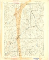
 1892 Worcester1892 Print · USGSWorcester and its northern hill towns are captured here in the late nineteenth century before the expansion of modern reservoirs. Researchers can trace the early rail networks through Sterling Junction or locate landmarks like the State Lunatic Hospital and Wire Village.10 unique versions available
 - 1893 Map of Franklin
 1893 Franklin1893 Print · USGSEastern Massachusetts at the close of the nineteenth century was a landscape of busy rail junctions and riverside mill towns. Researchers can trace the era's industrial footprint through sites like City Mills, Medfield Junc., and the isolated Burnt Swamp Corner.8 unique versions available
 - 1893 Map of Fitchburg
 1893 Fitchburg1893 Print · USGSNorth-central Massachusetts at the close of the nineteenth century was a complex network of industrial valley towns and highland rail junctions. You can trace the path of the Cheshire Railroad as it winds past Lake Monomonac or explore the early street layouts of Fitchburg and Leominster.7 unique versions available
 - 1893 Map of Palmer
 1893 Palmer1893 Print · USGSHampden County and its surrounding borders are captured here during a peak era of rail expansion and water-powered industry. Researchers can trace the junction of major lines at Barretts Junction or locate vanished industrial hamlets like Duckville and Ellis Mills.9 unique versions available
 - 1893 Map of Blackstone
 1893 Blackstone1893 Print · USGSThe Blackstone River valley at the height of its industrial era reveals a landscape of vital mill towns and complex rail networks. Genealogists and historians can trace the early footprints of Whitinsville, Uxbridge, and Millville alongside landmarks like Purgatory Chasm.2 unique versions available
 - 1893 Map of Belchertown
 1893 Belchertown1893 Print · USGSThe Swift River valley is shown here in the 1890s, years before the landscape was fundamentally altered. Genealogists can trace family homes and rail routes through Enfield, Prescott, North Dana, and the Boston & Albany R R.8 unique versions available
 - 1893 Map of Brookfield
 1893 Brookfield1893 Print · USGSCentral Massachusetts in the late 1800s was a landscape defined by bustling mill towns and the critical Boston and Albany Railroad corridor. Genealogists can trace family roots in early industrial centers like Fiskdale and Westville or locate the old Lead Mine near Holland.7 unique versions available
 - 1893 Map of Groton, 1905 Print
 1893 Groton1905 Print · USGSNorthern Massachusetts and the New Hampshire borderlands are shown here in the late nineteenth century as a hub of river industry and rail commerce. Researchers can trace historic sites like Shaker Village, the Groton School, and manufacturing hubs at Paper Mill Village.8 unique versions available
 - 1894 Map of Winchendon
 1894 Winchendon1894 Print · USGSNorth-central Massachusetts and the New Hampshire border are captured here during a peak era of rail-driven industry. Genealogists and historians can trace the development of mill villages and family landmarks like Powers Mills, Baldwinville, and the Cheshire Railroad.6 unique versions available
 - 1894 Map of Warwick
 1894 Warwick1894 Print · USGSNorthern Massachusetts and New Hampshire borderlands are captured here in the late nineteenth century, showing a landscape shaped by the Millers River. Researchers can trace the path of the Central Vermont Railroad and find early settlements like Wendell Depot and Northfield.6 unique versions available
 - 1894 Map of Barre
 1894 Barre1894 Print · USGSWorcester County in the late nineteenth century is defined here by its bustling river towns and the convergence of two major rail lines. Researchers can trace ancestral roots through family-named landmarks like Hawes Hill or explore the early industrial layout of Old Furnace and Barre Plains.7 unique versions available
 - 1894 Map of Framingham
 1894 Framingham1894 Print · USGSMiddlesex County in the late nineteenth century is a landscape of thriving rail depots and literary landmarks. Genealogists and historians can trace the foundations of local life at the Wayside Inn, the State Prison, and the Mass. State Muster Grounds.11 unique versions available
 - 1896 Map of Marlboro
 1896 Marlboro1896 Print · USGSCentral Massachusetts in the late nineteenth century is a landscape of thriving mill towns and interlocking rail lines. Researchers can trace the Victorian-era footprints of Marlboro and Clinton, locating vanished stops like Still River Station and family landmarks like Whittemore Hill.
 - 1898 Map of Marlboro
 1898 Marlboro1898 Print · USGSCentral Massachusetts was a thriving network of rail and river industry at the end of the Victorian era. Genealogists and historians can trace the early layouts of manufacturing hubs like Clinton and Hudson or find smaller vanished locales like Rockbottom and Pratt Junction.8 unique versions available
End of results
Showing maps 1-18 of 18
Top cities of Worcester County
- Worcester historical maps
- Leominster historical maps
- Fitchburg historical maps
- Shrewsbury historical maps
- Milford historical maps
- Gardner historical maps
See more
Frequently asked questions
- What are the different types of historical maps available for Worcester County?
- What is the oldest map of Worcester County?
- Where can I purchase historical maps of Worcester County for my home or office?
- Where can I download high-res historical maps of Worcester County?
- Are there historical topographic maps available for Worcester County?
- Is there historical aerial imagery available for Worcester County?
- Where are historical maps of Worcester County sourced from?